Colder Weather Returns…Light Snow Likely Friday

After a nice period of warm weather, a cold front came through this morning, allowing a Canadian airmass to build into the region.  Strong cold-air advection will cause temperatures drop through the 40s and into the 30s later this afternoon and evening. Windy conditions will continue with northwest winds 20mph to 30mph gusting to possibly near 45mph at times this afternoon. Temperatures will drop into the lower to middle 20s tonight, with northwest winds diminishing to 10mph to 20mph. Tomorrow will be mostly sunny with high pressure remaining in control. High temperatures will be in the middle to upper 30s — well below average for this time of year.

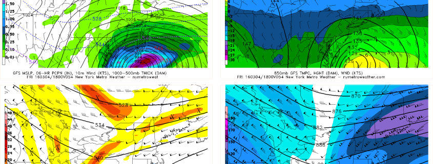
Model guidance is in agreement that a low developing over Southeast US will track well south and east of the region on Friday. This is because while the polar vortex will be lifting out Southeast Canada, the flow is too progressive to allow the upper-level trough to amplify enough for the storm to track closer to our region. Another disturbance rolling over the West Coast ridge, will keep this storm moving out into the Western Atlantic.

Read more

Warmer Temperatures Return Sunday and Early Next Week

Winter weather is with us through tonight, as temperatures remain quite cool. The good news? Some early spring-like weather is just around the corner, as temperatures will moderate and warm quite a bit on Sunday.

Mid-level height rises and deep southwest flow on Sunday, will help temperatures rise into at least middle to upper 50s with plenty of sunshine. It’s not out the question that some locations, particularly over Central New Jersey, will reach 60 degrees tomorrow afternoon. The southwest winds off the ocean or sound could keep temperatures cooler for parts of Long Island and Connecticut.

Read more

Heavy rainfall, thunderstorms, gusty winds possible tonight

A large deep low, which has been producing some severe weather and tornadoes over parts of Deep South over past few days, will be heading northward into Eastern Ohio Valley today. This storm will send a cold front northward through the Mid-Atlantic region this afternoon and evening.

Ahead of this front, positive vorticity advection, strong jet streak forcing and instability will be increasing. A convective or forced squall line is likely to develop over Central Pennsylvania southward into Virgina, with torrential downpours and gusty winds  near the low. Further south there is potential for more severe weather and tornadoes with greater instability. The Storm Prediction Center has issued large area of enhanced and moderate risks for parts of Virgina North Carolina, with slight and marginal risks further up and down the East Coast.

Read more

Multi-hazard system will affect the area midweek

A large and intense low pressure system will form over the Mississippi River Valley and move northward toward the Ohio Valley and Southeast Canada this week, as a result of an impressive phase in the mid and upper levels of the atmosphere. In our area, two distinct areas of low pressure will actually impact our weather; the first from Tuesday into Tuesday Night, and the second from Wednesday into Thursday. Both will feature wildly differing weather conditions, with snow possible across the interior on Tuesday and then heavy rain, warm temperatures, and thunder on Wednesday Night from the second storm system.

Read more