Weekly Overview: Pleasant fall week ahead

Another Monday morning is underway, which means it’s time for our weekly overview post! It is our hope that these posts can get you through the struggles of the next few hours at work. The weekend is a memory now — so it’s time to start talking to your coworkers or friends about anything good that happened, and well past the time to start forgetting about anything else. Anyway — a fast past weather pattern remains underway for this upcoming week — except this time, we’ll be on the good side of it, with only one brief chance for showers on Tuesday afternoon. Otherwise, the weather looks extremely pleasant. Temperatures will still be a hair below normal, with highs in the 70’s and cool nights.

Express-Cast 

Today: Sunny, highs near 70. | Tonight: Partly cloudy. Lows mid 50’s.

Read more

PM Roundup: Increasing clouds, dreary Saturday

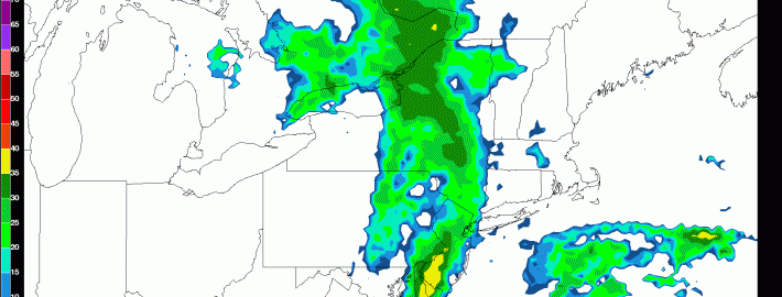
The big cold front came through last night and gave way to an absolutely gorgeous Friday, as temperatures rose into the mid to upper 70s with very low humidity and crystal clear skies. However, this is about to change, as a storm system will be developing throughout the evening, and affecting us tomorrow. The culprit is a rigorous system in the middle of the atmosphere pushing through the Great Lakes, which will help create copious lift for precipitation. Ultimately, the storm system will not become a truly organized Nor’easter, so we do not expect much in the way of heavy rain. But the fact that we have a storm system that will not be relying on convection leads us to have relatively high confidence in periods of rain throughout the day tomorrow. That being said, the lack of surface organization creates some uncertainty as to whether we will get around one tenth of an inch of rain, or closer to a half inch.

Today's 18z NAM showing a period of light to moderate rain throughout the area tomorrow afternoon.

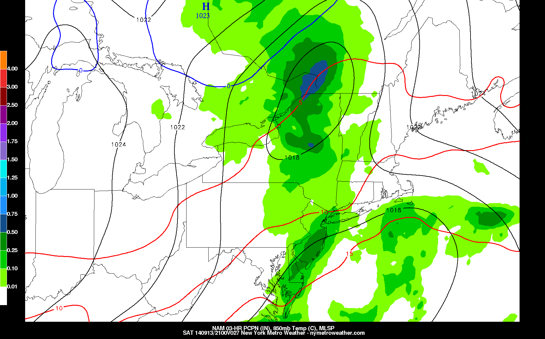
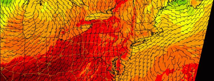
Today’s 18z NAM showing a period of light to moderate rain throughout the area tomorrow afternoon.

Tomorrow morning doesn’t look too bad — just cloudy with occasional sprinkles. Most of the rain should fall during the afternoon. Gradual clearing should commence tomorrow evening, as temperatures fall into the 50s in most locations, and perhaps into the 40s in some suburbs. Sunday looks to be a gorgeous day, with temperatures rising into the mid 70s and plenty of sunshine. Sunday night into Monday morning looks to be the chilliest night of the season; here is the forecast from the 12z GFS — though the model is probably a bit chillier than reality.

In addition to the coming cold temperatures, here are some other interesting links in the world of weather:

1) Recent solar flares have led to the potential of the sighting of the Aurora Borealis. The X-Class Solar Flare reaching Earth too early may reduce our chances to see it, however. For more information, check out our recent article giving everything you need to know. 

2) A weak tropical wave is beginning to form just off the coast of Florida. The eventual strength of this system is very uncertain, though a major hurricane is unlikely. Here are some of the latest forecast tracks by some computer models. 

3) While this El Nino has not progressed as forecast, and will most likely not be a super strong one, there are signs that it may just be delayed, but not denied. The Climate Prediction Center shows how warm water continues to build just below the surface of the Equatorial Pacific, which may emerge to the surface. This could allow waters to warm enough to get an El Nino back on track.

Have a great weekend, everyone!


Scattered thunderstorms later today in advance of strong cold front

After a lovely fall day on Wednesday, the humidity is back on the rise, as we revert back to summer. The culprit is a storm system and associated strong cold front — the latter of which will be passing through our area on tonight. Immediately out ahead of it, however, will be an increase in southerly winds and a warmer airmass. Often times, a warm, humid airmass in conjunction with a strong cold front can trigger strong thunderstorms. Initially, the threat for severe weather looked pretty high, but as we illustrated in yesterday’s article, there was major uncertainty as to the degree of instability that the atmosphere would hold. As we approach Autumn, high instability values tend to be harder to come by, and as we got closer to today, models gradually backed off on the degree of instability.

CAPE stands for Convective Available Potential Energy — the higher these values are, the more potential the atmosphere has to support strong, organized lifting for strong thunderstorms. Typically, values around 1,000 J/KG support marginal severe weather, while values 1500 J/KG and higher are more likely to support severe weather. With our area hovering only around 500 J/KG, it will be hard to expect much in the way of severe weather. That being said, this cold front will pack quite the punch with potent dynamics. This will allow for strong wind shear — in the order of around 40 knots — from the surface through the middle of the atmosphere. This means that any thunderstorm that does form could still produce strong wind gusts. Notice how further to the south, the CAPE values are higher, but the wind shear values are much lower — there is no truly impressive juxtaposition between the instability and the wind shear that is often necessary for widespread severe thunderstorms.

Read more

Morning roundup: More sun, a bit warmer today

Onshore winds and cooler temperatures made Tuesday a bit of a dreary day, especially in the evening. Although a developing coastal storm remained offshore, some bands from the system rotated inland and brought drizzle and sprinkles to the coastal areas of New Jersey and New York Tuesday Night. Decreasing moisture in multiple levels of the atmosphere on Wednesday will lead to improving conditions in much of the area, although clouds and a shower cannot be ruled out. Warmer temperatures are expected, in general, with highs in the 80’s.

A developing storm system in the Central United States will bring changing weather to our area by Thursday. Winds will shift from east/northeast to southerly by Thursday afternoon, ushering in much warmer air and allowing for an increase in humidity. A strong cold front eventually will approach the area by Thursday evening.

Read more