April off to a wonderful start with warming trend

Maybe it’s best that we just forget about March as a whole. The only people who would’ve enjoyed March 2014 are those who enjoy cold temperatures and no snow — a rare breed — and so most were lift disappointed and chilly. Spring got off to a slow start, with temperatures running 4 to 6 degrees below average during the month of March. And there was almost no snow to speak of in New York City despite multiple chances for accumulating snowfall. April, on the contrary, will get off to a great start. Temperatures in the mid 50’s to near 60 on Tuesday will mark the beginning of a warming trend which will continue into the middle of the work week.

High temperatures by Wednesday should eclipse the lower 60’s in many locations, as westerly winds and warming mid level temperatures with full sunshine allow for the warm air currently over the Tennessee and Ohio Valleys to advect eastward. Par for the course this time of year, things will be a bit cooler near the area beaches and shores. Despite the westerly winds, cold ocean waters make it very difficult for coastal locations to stay warm throughout the day in April. By the end of the week, the forecast gets a little bit more dicey with an approaching warm front and the potential for some backdoor-front action from New England.

HRRR model showing high temperatures exceeding 60 degrees west of NYC on Tuesday.

HRRR model showing high temperatures exceeding 60 degrees west of NYC on Tuesday.

Read more

Impressive Rain Storm 3/29 – 3/31

An impressive storm system is going to effect the Tri-State area this weekend into early Monday morning. The set-up in the upper atmosphere (500 mb) supports a long duration rain storm with frequent moderate to heavy rains which increases the flood threat, especially in areas where there is still snow / ice and if you live in a flood prone zone.

Timing:

Start: 12pm-1pm Saturday

End: 5am-7am Monday

This equates to 40+ hours of rain falling which when all is said and done could add up to 4+ inches of rain in some spots of the Northeast. Obviously the rain is not going to be heavy for 40+ hours. In fact, there may even be a brief break in the action before it starts up again. Nonetheless, we are still looking at a washout weekend with a potent coastal storm developing.

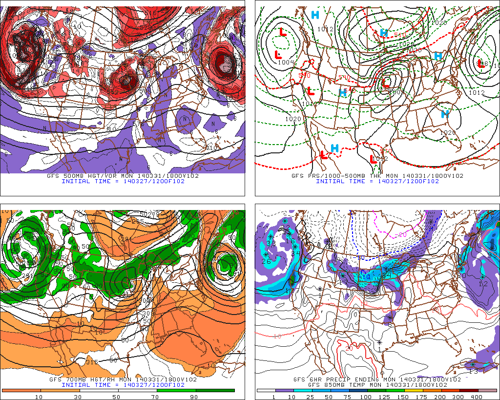
The 00z GFS 500 mb map by 2pm tomorrow is beginning to show a phase with the northern and southern stream energies in the atmosphere which will result in a strong surface low developing. By this time, rain is streaming up the coast into the northeast ahead of the surface low with the heaviest falling over Long Island.
Fast forward into early Sunday morning, and now those energies have completely phased with the H5 trough now closed off. At this time, very heavy rain is falling throughout NY state, the northern tier of PA, NNJ, and NYC into LI.
By Sunday night, the closed off low deepens with the H5 trough now going negative, prompting the coastal low to slow down and bring training moderate to heavy rainfall over parts of the coast from PA into NJ into NYC.
What is happening here is we are seeing the effects of Atlantic blocking and what it could do to east coast storms. Throughout this winter, we have been in a relatively zonal flow due to a constant +NAO with only a north-Atlantic ridge trying to help slow the flow down.
This time, the combination of positive heights into Greenland and eastern Canada have forced this storm to CUT-OFF from the jet stream and almost come to a stall off the coast of NJ. The good news is this will not be some 950 mb bomb of a storm that is bringing hurricane force winds to the area. It is expected to remain on the weak side with the worst of the winds along the immediate coast, where 30-40+ mph gusts can be expected.
RAIN MAP
Region wide, we are looking at 1.50-2.50 inches of rain for the most part. In further assessment, I can see how red-shaded areas receive possibly more than 3 inches of rain due to the positioning of the stalling low pressure storm off the coast of NJ. Some pieces of guidance support this notion of sending bands of rain over this area which would enhance rainfall totals. Obviously flooding in NNJ near the rivers could be a concern, but I do not believe rivers are in danger of flooding since it has been pretty dry of late. However, that does not mean roads that flood easily will not flood. So please keep that in mind.
Enjoy this miserable weekend,
Frank


Warmup begins, brings unsettled weather

After a powerful Nor’Easter which featured a minimum central pressure of 955mb and wind gusts over 80mph on Nantucket, cold air swept back into the area late Wednesday into Thursday. Wind gusts in our area were more modest, but still over 30 mph in many spots. The cold airmass which moved into the area helped us set records of our own on Thursday morning. LaGuardia, Newark and Kennedy airports all set record low temperatures for the day, breaking records which were set during a similar cold snap in 2001. The departure from normal temperature remained more impressive than the actual surface temperatures, which actually only fell into the low 20’s. Normal lows this time of year, however, are in the mid to upper 30’s.

Fortunately, the colder than normal airmass will fall victim to a very progressive pattern, and is already on its way out. Temperatures on Thursday afternoon will rise into the 40’s to near 50 in many areas, under full sunshine and warming temperatures aloft. A continued warmup is expected from Saturday through the early part of next week. However, with the warmth will come southerly winds, increased moisture and a few low pressure systems which will do their part to provide the area with unsettled weather and multiple chances for rain.

GFS model showing a parade of systems moving eastward from the Pacific into the United States.

GFS model showing a parade of systems moving eastward from the Pacific into the United States.

Read more

Strongest storm of season likely to spare our area

In what will all but certainly be winters dying breath, a large and powerful coastal storm will develop Tuesday into Wednesday off the southeast states while traversing northeastward to a position southeast of the 40/70 benchmark. In doing so, and owing to a major phase in the mid levels of the atmosphere, the storm will strengthen rapidly and explosively — dropping from around 990mb to somewhere in the 950’s mb. This will make the system the strongest of the season by far, and the strongest in our area since Hurricane Sandy.

The aforementioned phase involves three disturbances which originate from different parts of the mid level flow and jet stream. Pacific and polar energy will merge over the Northeast United States, and a favorable jet structure will allow for rapid strengthening of the low pressure system. More notable for us, however, is how all of this will occur a hair too slow and a tick too far east/northeast — allowing us to dodge what would’ve otherwise been an incredibly high impact storm system.

NAM model showing a major storm system developing offshore, barely grazing the coast.

NAM model showing a major storm system developing offshore, barely grazing the coast.

Read more