Chilly weather remains entrenched through tomorrow

Just two days ago, parts of New Jersey were approaching 80 degrees. Then yesterday, a strong cold front came through and gave most of the region minor accumulations of snow and sleet! Newark Airport officially recorded 0.4″ of snow, LaGuardia Airport had 0.3″, New Brunswick, NJ had 0.2″, and Freehold, NJ reported 1.5″ of snow.

The cold airmass responsible for the snowfall will remain entrenched for the rest of the afternoon, tonight, and tomorrow, as a cold high pressure system slowly slides eastward. It was to our northwest last night and this morning, which brought in strong northwesterly winds from Canada — its gradual approach shifted our winds to northerly, which is actually an even colder wind direction, keeping our highs in the 40s this afternoon. The winds have calmed a bit throughout the day, but are still blustery — however, as the high pressure continues to get closer, we will be directly underneath it, where winds are much calmer. Thus, we expect winds to keep getting calmer and be very light during the evening.

Today's high resolution NAM model shows temperatures falling to around freezing for tonight's overnight lows (PSU E-Wall).

Today’s high resolution NAM model shows temperatures falling to around freezing for tonight’s overnight lows (PSU E-Wall).

The initially calmer winds will feel nice; however, calm winds and clear skies associated with the high pressure — especially in a cold and dry airmass — lead to radiational cooling conditions. This will allow temperatures to quickly drop into the 30s this evening. As the night goes on, the high pressure will slide to the east of us, which puts us back into the flow of wind — this time, out of the northeast, so winds will increase to around 10mph as the night goes on.

Read more

Major cold front will bring rain, wind and temperature drop

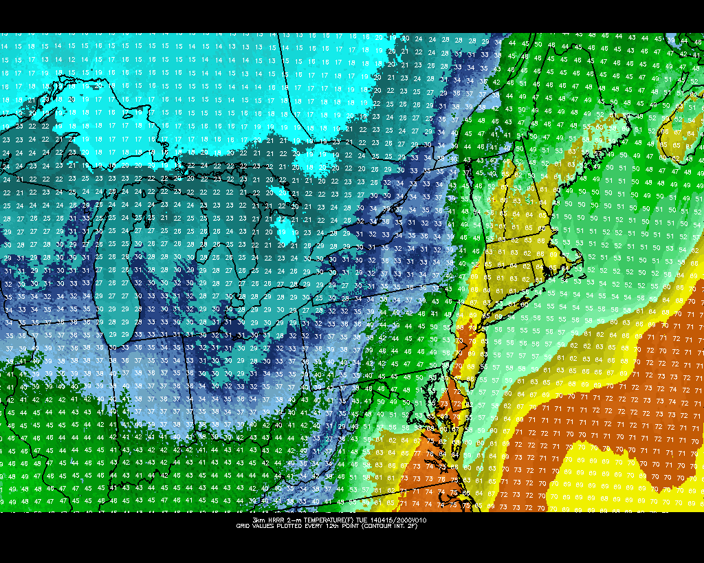
The warm, sunny weather of the past several days is on the way out. Although our area has experienced several cold fronts over the past few weeks, none have come with quite the vigor which Tuesday’s front will. Northwesterly winds behind the front, a strong mid and upper level system, and a fresh supply (seasonally speaking) of Canadian air will all accompany the frontal boundary. Southerly winds continued this morning ahead of the front, with a broad area of heavy rain lingering just off to our west. The winds are expected to pick up as the afternoon draws on.

Along the frontal zone, an impressive thermal gradient will exist later this afternoon. Forecast models indicate the potential for a 25-30 degree temperature drop during the evening. Widespread heavy rain is expected to be accompanied by embedded thunderstorms, which could drop over 1″ of rain throughout a majority of the area. Making matters worse (or more dramatic, depending on how you look at it) is the potential for strong winds, nested just above the surface, to mix down in this heavier precipitation. Forecast models indicate the potential for wind gusts of 30 to 40 miles per hour as the front passes.

A strong cold front will approach the area this afternoon, with a  dramatic temperature gradient.

A strong cold front will approach the area this afternoon, with a dramatic temperature gradient.

Read more

Warmup continues ahead of cold front

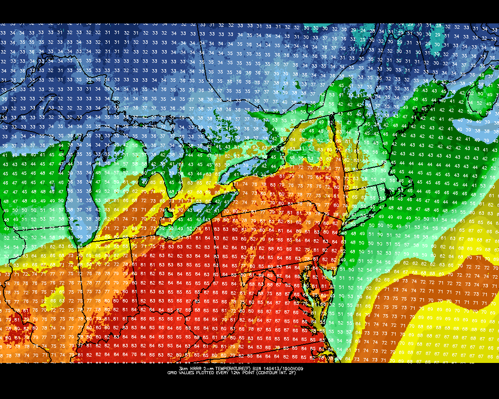
Temperatures in the 70’s, plenty of sun, and a light breeze were the main characteristics of the weather throughout much of the area on Saturday, during a day which likely will be remembered as one of the more pleasant in recent memory. Much of the same is expected on Sunday — in fact it will be a few degrees warmer — as high pressure moves east of the area and the airmass modifies further. Southerly winds will continue to pump in warmer air both aloft and at the surface, so much of the area away from the coast will warm up into the upper 70’s if not 80’s.

The only exception will come near the area coasts, where cool marine air will rear its ugly ahead once again. A slightly southeasterly component to the wind will introduce an influx of colder air off of the ocean waters, which remain in the 40’s. Forecast models with higher resolution are picking up on temperatures in the 40’s and 50’s along the south shore of Long Island and New Jersey coast. While this may be somewhat aggressive given the initial diurnal heating likely this morning, temperatures in the 50’s and 60’s should be more common near the coast with the possibility of low clouds rolling in off the water and blustery southeast winds.

HRRR model showing high temperatures in the 80's on Sunday, but temperatures only in the 40's and 50's near the shore.

HRRR model showing high temperatures in the 80’s on Sunday, but temperatures only in the 40’s and 50’s near the shore.

Read more

Finally! 70 degree temperatures possible this weekend

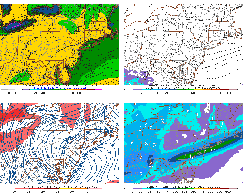
After a long, cold winter which was characterized by below normal temperatures and above normal snowfall, even the slightest sign of spring in 2014 has felt incredibly refreshing. Temperatures this week, so far, have warmed into the 60’s with a noticeable westerly breeze. The cold, freezing nights are becoming a memory at this point as air masses modify and the source of dramatically cold air moves farther away from our area. Things look to improve even further by late this weekend, when a warm southerly flow could warm temperatures into the 70’s.

Forecast models have been jumping around  a bit with their exact handling of multiple disturbances moving through the United States during the latter half of this week into the weekend. But recent agreement on the evolution of the pattern lends confidence to the idea that warmer air is on the way by later this weekend. After a front moves near the area on Friday afternoon and slows down a bit, allowing for a period of rain later Friday into Saturday, the front will wash out and weaken by Saturday morning. And so as a storm system develops well to our west over the Central United States, warm southerly winds will usher in milder air that will ultimately bring our temperatures near or over 70 degrees by later this weekend.

NAM model forecasting high temperatures in the mid 60's throughout the area on Saturday, with cooler air near the coast.

NAM model forecasting high temperatures in the mid 60’s throughout the area on Saturday, with cooler air near the coast.

Read more