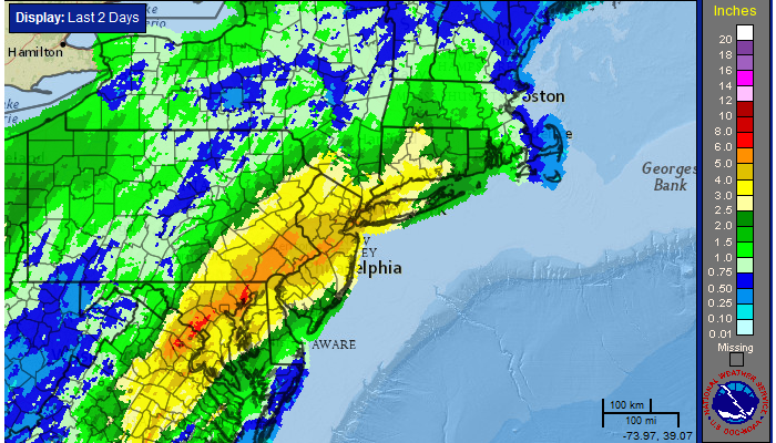
Widespread flooding rains occurred on Wednesday as a significant plume of tropical moisture surged northward along a frontal zone, which was draped near the area. Heavy rain “trained” northeastward from the Mid-Atlantic states towards New Jersey, New York City and parts of Southern New England. Rainfall amounts over 4″ were widespread, especially in parts of Central and Northeastern New Jersey. The result of prolonged heavy rain was widespread river, creek and poor drainage flooding which resulted in some property damage and a significant amount of road closures.
The rainfall, in fact, was as prolific as it seemed. The 4.97″ which fell at New York City’s Central Park was the 10th highest daily rainfall total in the reporting stations history, and the 2nd highest during the month of April. The 7.85″ which fell during the month of April made it the 6th wettest April in the reporting stations history.
24 Hour radar estimated rainfall totals, courtesy of the National Weather Service.
https://www.nymetroweather.com/wp-content/uploads/2024/02/Empire-2000-x-300-px-2.png00John Homenukhttps://www.nymetroweather.com/wp-content/uploads/2024/02/Empire-2000-x-300-px-2.pngJohn Homenuk2014-05-01 07:19:212014-05-01 08:58:22Flooding rains give way to storms, warmer air
Although it has been quite the grey, dreary, chilly day, rainfall throughout the area has not been all that heavy yet. The main reason for this is because the surface pressures are still quite high, thanks to a large high pressure system north of Maine, which is wedging in very high pressures into the area. Higher surface pressure is an indicator of downward motion in the atmosphere, which is not conducive to precipitation.
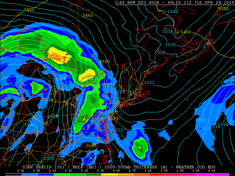
This afternoon’s NAM valid for 5:00pm shows a large high pressure system to the north, with high pressures still wedged into our area. This is why a lot of the rain has broken up as it has headed east (weather.cod.edu).
The image above explains it well — note the blue isobars of higher pressures that are being “pushed” into our area. The lower pressures are relegated to the west, southwest, and northwest, while the higher surface pressures are to the north and northeast. The station pressure at Rutgers Gardens is 1027mb. That is certainly not conducive for heavy precipitation. This is further augmented by the fact that an associated warm front is still well to the south of the area. If the atmosphere is going to generate lift for precipitation with high surface pressures, we need forced ascent from a frontal boundary, which will finally be approaching the area on Wednesday.
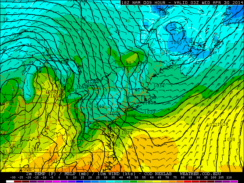
Moving forward through 11:00pm tonight, the surface pressures remain high, and the warm frontal boundary is still well to the south. This most likely means the Yankees will play baseball tonight (weather.cod.edu).
However, over the next several hours, notice how the strongest temperature gradient associated with the warm front is still well to the south, and the high surface pressures are still being wedged in. This combination leads us to believe that any rain that falls this evening and tonight will be very light, and not enough to cancel the Yankee game. As time goes on, the warm front will slowly be approaching the area, and the easterly winds from the cold, yet moist ocean will finally be enough to moisten the atmosphere and generate the necessary lift for precipitation.
https://www.nymetroweather.com/wp-content/uploads/2024/02/Empire-2000-x-300-px-2.png00Doug Simonianhttps://www.nymetroweather.com/wp-content/uploads/2024/02/Empire-2000-x-300-px-2.pngDoug Simonian2014-04-29 17:27:222014-04-29 18:08:00Bouts of heavy rain expected through Thursday
The same storm system that gave Arkansas a powerful tornado last night, and will very likely be giving parts of the Mississippi Valley more powerful tornadoes, will be very slow to drift northeastward, thanks to an Omega blocking pattern. This will eventually usher in a multi-day period of rain, starting tomorrow afternoon, and lasting through Thursday.
What is currently a large, cutoff trough will cut off even more from the general jet stream flow over the next day or so, as it very slowly drifts northeastward. This allows it to remain to the west enough to be able to generate Gulf of Mexico moisture, but far enough to the northeast for it to reach our latitude. Had the storm been smaller in scale, the moisture would not have been as expansive in nature.
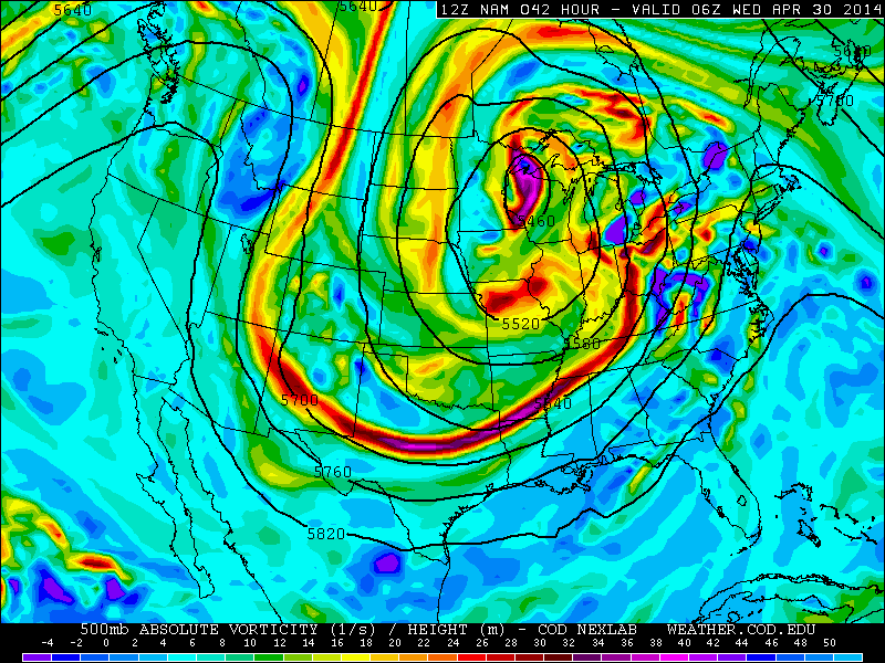
Today’s NAM at 500mb, valid for 2:00am Wednesday morning, shows a large cutoff low dominating the United States, which will be bringing plenty of clouds and rain during this work-week (weather.cod.edu).
Notice the large storm system that will be in the Upper Midwest, and all of the closed, circular 500mb height contours wrapping around it. This indicates a large cutoff low that is slow to move, which is mainly triggered by the large Omega blocking to the north of the system. For more on Omega blocking, check out our article from Friday. The most efficient lifting for precipitation tends to occur on the east side of a trough, which is exactly where we will be. Also notice how to the east of the trough, the height contours are oriented from the Gulf of Mexico, straight northeastward towards our area. That will be the general track of the rain.
Let’s move forward with more details on the rain itself and its timing.
https://www.nymetroweather.com/wp-content/uploads/2024/02/Empire-2000-x-300-px-2.png00Doug Simonianhttps://www.nymetroweather.com/wp-content/uploads/2024/02/Empire-2000-x-300-px-2.pngDoug Simonian2014-04-28 15:47:412014-04-28 15:55:52Gradually increasing clouds will lead to an unsettled week
As a lovely Friday afternoon is unfolding, meteorologists continue to look at a very anomalous blocking pattern which is forecast to develop over the next several days, which will bring vast changes to the weather pattern. A blocking pattern, when strong enough, can slow down the entire weather pattern, and force storm systems to cut off from the jet stream and stall. This will be the main culprit to our unsettled weather next week — particularly from Tuesday through Thursday. It will not be a total washout, but it will still be quite unsettled, so make sure to carry your umbrellas with you next week.
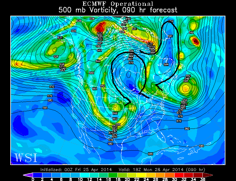
Let’s take a look at the weather pattern that is forecast to develop on Monday afternoon, on last night’s European Model. We are looking at the 500mb pressure level, which is right around the middle of the atmosphere. The image below has thin black contours, showing how high you have to go to drop to a pressure of 500mb (500mb heights) — the higher the height, the more expansive the column of air is, which is associated with warmth and ridges. The opposite is associated with cold air and troughs. When a ridge becomes strong enough, it can also cut off from the jet stream and become a block. The shaded colors are areas of vorticity, or general counterclockwise spin in the atmosphere, which is often associated with storms or storm formation.
Last night’s European Model shows a duel Omega blocking pattern next week (WSI Model Lab).
Taking a look at the weather pattern shown above for Monday afternoon, the main features have been outlined in black — there are two Omega blocks — notice how they are both shaped like the Greek letter Omega. Normally, storm systems can progress throughout the country in a west-to-east fashion, or perhaps quickly turn to the northeast. However, when a storm runs into the influence of a strong Omega block, the block serves as a brick wall. It slows down all west-to-east movement. This forces any storm system to essentially stall — often underneath the Omega block on adjacent sides of it.
Off the east coast, we see a large closed off upper level low. This was initially the disturbance that will slide through tonight and tomorrow night. It slowed down and cut off, due to the presence of the Omega block south of Greenland. The atmosphere often seeks to balance itself out — so when there is a strong, closed off ridge (Omega block), any adjacent storm system or trough also tends to become strong and closed off — especially considering it stalls so long that it has time to do so. The close proximity of that strong storm system and associated energy — particularly the energy between the two blocks — will become important, and we’ll explain shortly.
Hi friends! Our website uses cookies to provide an optimal browsing experience for you. New "Cookie Consent" laws mandate us to inform you of this. As long as you're cool with it, just hit OK. You'll only see this message once.
We may request cookies to be set on your device. We use cookies to let us know when you visit our websites, how you interact with us, to enrich your user experience, and to customize your relationship with our website.
Click on the different category headings to find out more. You can also change some of your preferences. Note that blocking some types of cookies may impact your experience on our websites and the services we are able to offer.
Essential Website Cookies
These cookies are strictly necessary to provide you with services available through our website and to use some of its features.
Because these cookies are strictly necessary to deliver the website, refusing them will have impact how our site functions. You always can block or delete cookies by changing your browser settings and force blocking all cookies on this website. But this will always prompt you to accept/refuse cookies when revisiting our site.
We fully respect if you want to refuse cookies but to avoid asking you again and again kindly allow us to store a cookie for that. You are free to opt out any time or opt in for other cookies to get a better experience. If you refuse cookies we will remove all set cookies in our domain.
We provide you with a list of stored cookies on your computer in our domain so you can check what we stored. Due to security reasons we are not able to show or modify cookies from other domains. You can check these in your browser security settings.
Other external services
We also use different external services like Google Webfonts, Google Maps, and external Video providers. Since these providers may collect personal data like your IP address we allow you to block them here. Please be aware that this might heavily reduce the functionality and appearance of our site. Changes will take effect once you reload the page.
-2")