Moderate snowstorm likely on Monday

A low pressure system developing along a stalled frontal boundary is likely to bring precipitation to the entire area beginning early Monday morning, with cold air funneling in from the west/northwest behind the front and changing precipitation to snow throughout the area. Forecast models have trended much farther north and more expansive with the precipitation shield associated with this low pressure — and as a result, we are now expecting the potential for moderate snowfall accumulations throughout the area. There are several uncertainties still remaining with the forecast system, including timing and temperatures, but confidence continues to increase in the accumulation forecast today.

Snow is expected to begin in Northern NJ, NYC, SE NY and Connecticut during the early morning hours on Monday. Across parts of Central and Southern NJ, precipitation may begin as rain or may be mixed. As precipitation intensity increases, dynamic cooling will occur — changing most areas to snow. The exception may be in Southeast NJ and parts of Long Island, near the coast, where warmer air in the low levels will keep precipitation mixed or stop snow from accumulating. Elsewhere, moderate to heavy snow is then expected to continue throughout much of the morning and early afternoon.

Storm Total Snowfall Forecast as issued by our meteorologists on February 2, 2014.

Read more

Super Sunday warmup will be short lived

Given the nature and degree of the cold snaps so far this winter season, it seems like every warm up deserves a lot of attention. There have only been a few this year (most notably one in December and one in mid January) — and another is on the way this weekend. Conveniently timed during the Super Bowl festivities in New York City, a low pressure system will ride to the north of our area on Sunday providing a warm southerly fetch out ahead of it. The bulk of precipitation associated with the storm looks likely to stay north of our area as well, with just a few showers possible on Sunday.  There is also some potential for a period of steady rain early Sunday morning across Southern New Jersey.

Sunday will feature some of the warmest weather in weeks as high temperatures will rise through the 40’s and approach 50 during the day. A cold front will move towards the area Sunday Night — during the Super Bowl — and the wind shift will mark a change (or return) to a colder and more wintry airmass. Northwest winds will usher in much cooler air aloft and at the surface by Sunday Night, with the front moving just east of the area. But the story doesn’t end there. A developing disturbance over the Southern US will shift northeastward along this frontal boundary, potentially resulting in a winter weather event on Monday.

NAM model forecasting high temperatures well into the 40's on Sunday afternoon.

NAM model forecasting high temperatures well into the 40’s on Sunday afternoon.

Read more

Coastal storm departs, cold air persists

The storm system which brought significant winter weather to the Gulf Coast and Southeast States over the past two days still found a way to scrape our area with light snow from Tuesday Night into Wednesday, with most areas east of the city receiving 1-3″ of fresh powdery snow. Those in Southeast New Jersey, especially Cape May county, will argue that the storm more than “scraped” us — there were multiple reports of over 6″ of snow. But the impacts were especially relegated to the coast this time, as the system headed seaward and banding associated with it battled with dry air farther inland.

Throughout the remainder of today, clearing skies will take over the area’s weather from west to east (with Eastern LI hanging on to some clouds for the longest). Cold air will funnel back in behind the storm system, with blustery west winds becoming noticeable by afternoon. Tonight’s Stadium Series game at Yankee Stadium in the Bronx will feature temperatures in the upper 20’s to teens, with blustery conditions. Bundle up for the game if you’re headed out!

Visible satellite imagery from the morning of Wednesday Jan 29 2014, showing the coastal system departing the area.

Visible satellite imagery from the morning of Wednesday Jan 29 2014, showing the coastal system departing the area.

Read more

Light snow likely tonight for coastal sections

As a major winter storm is hitting the Southeast, model guidance has made subtle shifts to the northwest, showing the storm grazing our area. However, climatologically speaking, a storm that dumps heavy snow to the coastal regions of the Southeast tend to track too far east for major snowfall to our region, which is what will occur this time around.

However, the precipitation shield is pretty expansive — expansive enough to allow some light snow to enter coastal sections late tonight through early tomorrow morning. The further south and east you go, the more likely you are to find a couple of inches of snow.

Today's 18z NAM valid for 4:00am Wednesday morning shows a progressive 500mb pattern, which explains why most of the precipitation will miss out to sea.

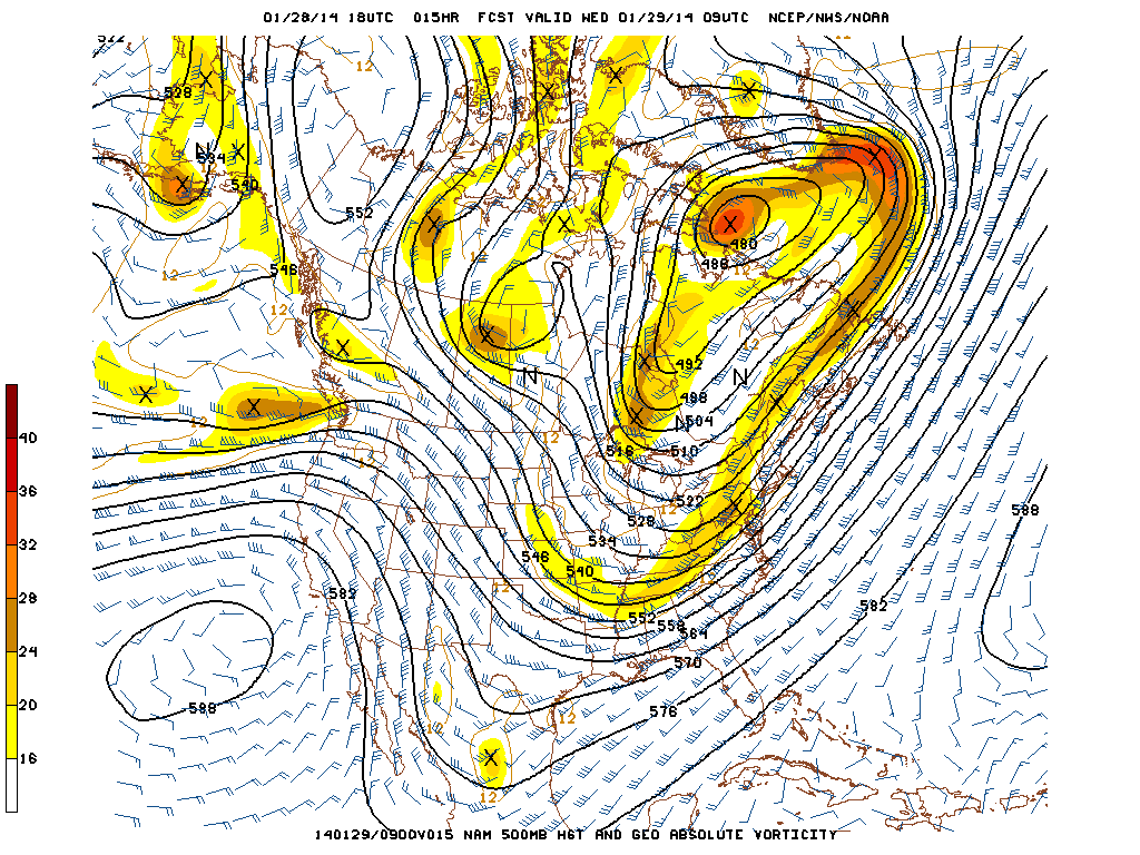
Today’s 18z NAM valid for 4:00am Wednesday morning shows a progressive 500mb pattern, which explains why most of the precipitation will miss out to sea.

One reason the precipitation shield becomes so expansive is because of vorticity that streams through the northeast, and vorticity maximum that is streaking through Eastern PA. This helps to tug precipitation back to the west, despite an offshore track. The reason why this storm will not be major snow producer is that the Polar Vortex is pressing down on the pattern a bit too much, giving very little room for our system to amplify — the wave spacing is poor. Thus, we are left with an elongated area of vorticity, which only supports light snow, as opposed to an area that is more consolidated and amplified.

Precipitation looks to start between 8:00 and 9:00pm in South Jersey, and between 10:00pm and 11:00pm for the rest of the region. The snow will primarily be quite light, with perhaps a few brief bursts of moderate snow, before ending between 5:00am and 7:00am tomorrow morning.

Today's 18z NAM valid for 1:00am Wednesday morning shows light snow moving into the region, with heavy snow remaining just offshore. Image credit goes to instantweathermaps.com

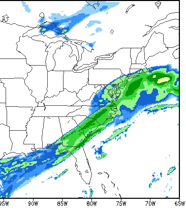
Today’s 18z NAM valid for 1:00am Wednesday morning shows light snow moving into the region, with heavy snow remaining just offshore. Image credit goes to instantweathermaps.com

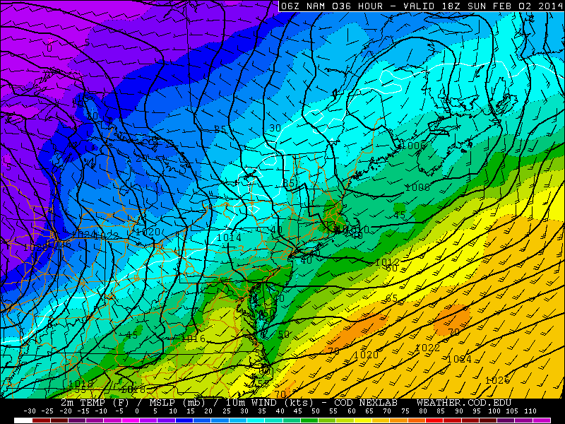
Today’s 18z NAM run gets light snow into the entire region during the overnight tonight. Temperatures will be quite cold throughout the entire atmosphere, so ratios could certainly be around 15:1 or so, but we do not foresee enough lifting in the atmosphere for ratios to exceed 20:1. Dry air will be quite prevalent on the northwest side of the system, so snowfall cutoffs will be quite sharp, and moderate to heavy precipitation will have a tough time advancing too far northward.

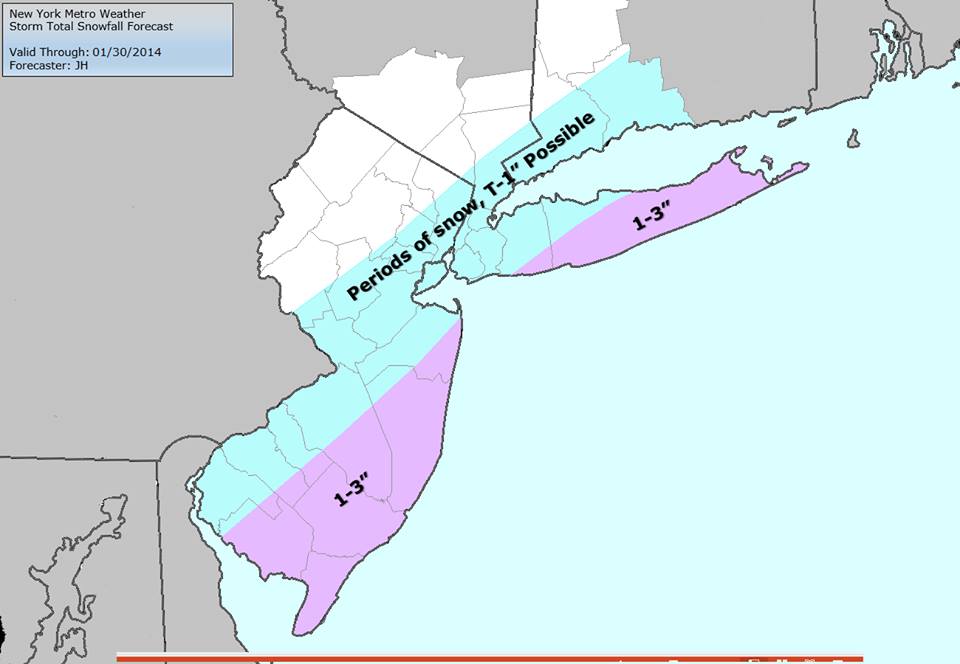
Our snowfall forecast map can be seen below:

Our snowfall forecast map for tonight's light snow event.

Our snowfall forecast map for tonight’s light snow event.

There is a chance that we may have to bump up parts of SE NJ and E LI into the 2-4″ range, however, since based on the subtle modeling trends, more precipitation may be able to sneak into eastern sections of the region. Although the large-scale weather pattern is not favorable for a major snow event, there is still enough uncertainty to warrant the chances of a 25-mile shift to the northwest, which could put places like Cape May County in a zone of even a 3-5″ potential. This would also shift the 1-3″ line back towards Southern Middlesex County and through Queens and parts of NYC. NYC itself should not get more than 2″, even in the “snowiest case scenario.”

Regardless, this event will still have to be watched closely, and we will keep you updated.