It’s almost as if “roller coaster” has become an insufficient way to describe the pattern changes that our area has observed over the past several weeks. This past 5-7 day period was no different, as we transitioned from the Polar Vortex with sub-zero wind chills to a strong southerly flow and temperatures in the 60’s. After a cold frontal passage on Saturday evening, however, things have settled down a bit. Monday will end up relatively benign with temperatures slightly above average — and minimal precipitation.
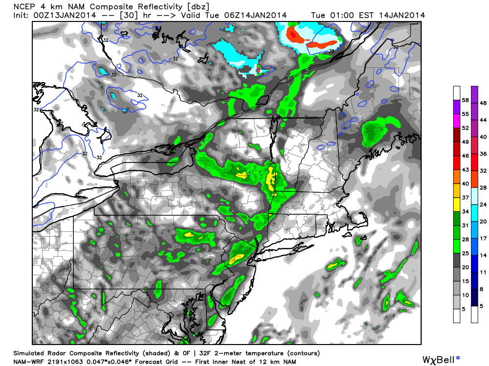
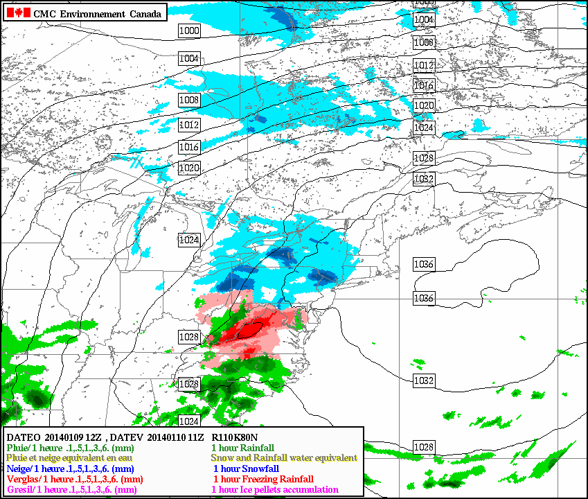
The changes begin by late Monday, however, as increasingly thick clouds will begin to stream into the area from the southwest. A mid level disturbance approaching the area from the Mississippi Valley will be moving quickly off to the northeast, and minimal amplification is expected with no significant low pressure system. Nevertheless, unsettled weather with clouds and showers will grab the reigns of the forecast from Monday Night into Tuesday. Above normal temperatures will eventually be shunted east of the area once again as more wintry air moves in behind the system by midweek.
NAM model showing the development of widespread showers and clouds throughout the area late Monday Night into Tuesday.
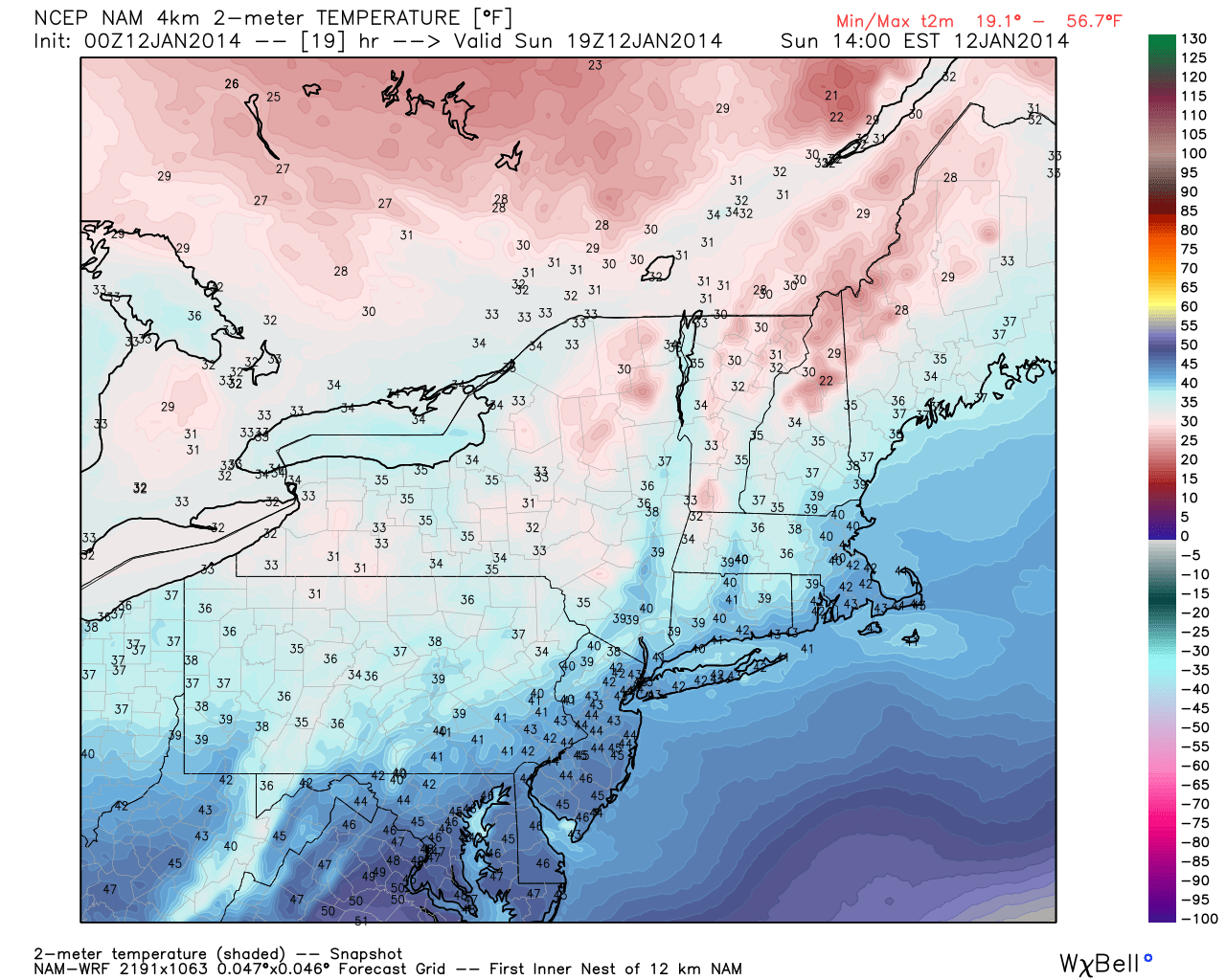
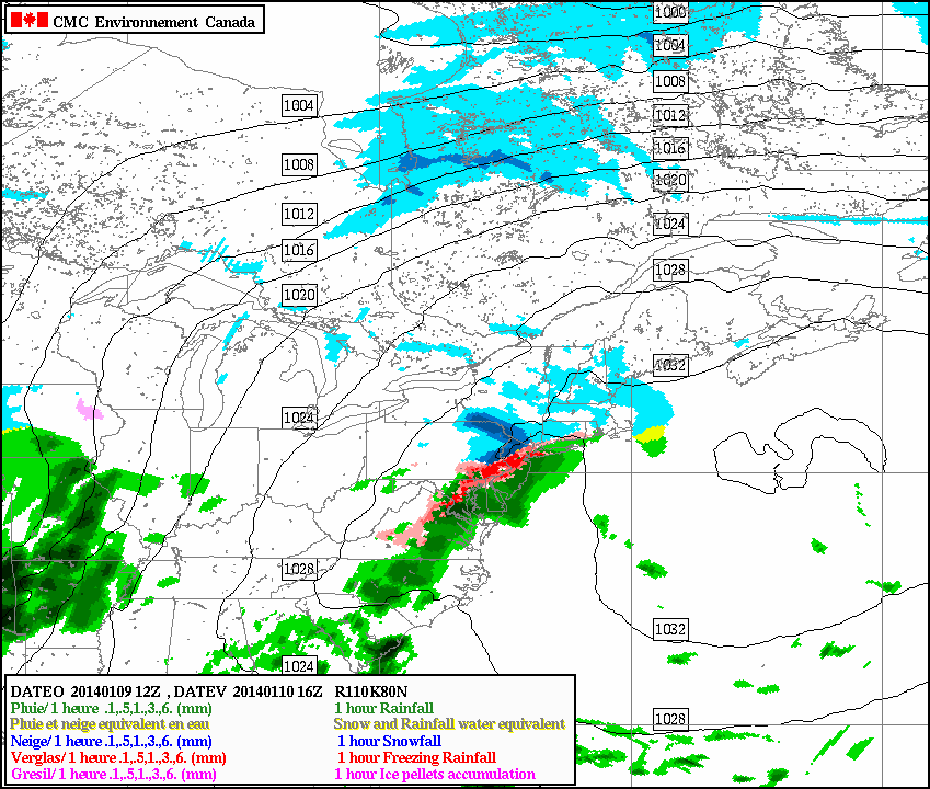
Warm, humid air with showers and thunderstorms were the main characteristics of the airmass on Saturday — but a distinct cold front moved through the area later on Saturday evening and the airmass has changed dramatically since then. Winds shifted from southerly to west-northwesterly by late Saturday evening into Sunday morning, and temperatures in the mid levels will drop even more considerably Sunday morning. Although overnight temperatures won’ t be frigid (especially in comparison to what we were dealing with 5 days ago), highs on Sunday will only reach into the mid 40’s, considerably cooler than Saturday.
Fair weather will be the main weather story through early week, despite the potential for a few showers on Monday. Sunday looks quiet, with around average temperatures and a westerly breeze. With no precipitation or hazards expected, it will be a sufficient close to a weekend which had only featured unsettled and dreary conditions to this point.
NAM model forecasting high temperatures in the mid 40’s on Sunday afternoon.
The snow and freezing rain this morning has left the immediate area, and gave most areas a coating to 1″ of snow, and also very treacherous roads. Now that the warm front has passed the area, temperatures have risen above freezing, moisture has increased, and dense fog is beginning to develop. An extremely saturated low-level profile will continue to promote an increase in fog as the night goes on, so all motorists should be extremely careful when traveling tonight, as visibilities will be below 1/4 of a mile at times.
However, a freezing rain advisory still exists for interior Central and Northern NJ, interior southern NY, and interior southern CT, as cold air has still remained at the surface. Areas close to NYC should change over to plain rain by midnight with less than a tenth of an inch of ice, and areas a bit further inland may remain below freezing until 4:00am, as a tenth of an inch of freezing rain could fall. Travel especially carefully in these areas. For more information on these advisories, see the embedded links.
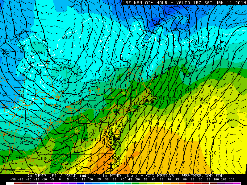
Moving forward to tomorrow, the weather will continue to get worse. A storm system will be deepening and cutting into the Great Lakes, leaving a cold front in its wake — all the way down to the Gulf of Mexico.
Today’s 18z NAM valid for tomorrow at 1:00pm shows a 988mb low in SE Canada with a cold front draped across the Appalachians.
The NAM model shows the cold front quite well. East and southeast of the 988mb low in SE Canada, winds are generally southerly and southeasterly; whereas to the south, west, and southwest of that low, the winds are generally westerly and southwesterly. Additionally, a classic indicator of a cold front is a pressure trough. The isobars are the solid black lines. In the area where the different wind directions are converging, there is a very well-defined pressure trough in Ohio and Kentucky, further proving the location of the cold front. It perfectly matches the region where the wind is changing in direction.
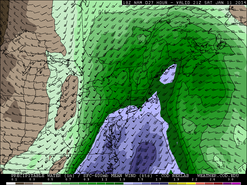
Today’s 18z NAM valid for 4:00pm tomorrow shows an area of very high precipitable water values streaming into the northern Mid Atlantic, an indicator of a significantly moist atmospheric column. This supports the potential for heavy downpours.
Although there is not a whole lot of cold air behind the front, the front is still powerful due to significant moisture differences, as well as an abundance of warm air and moisture out ahead of the front. The high preciptable water values shown above, as well as surface temperatures rising into the upper 50 and low 60s leads to low-density air that can easily be lifted. This warm and moist air being lifted by the cold front will help to trigger an area of heavy rain, and potentially enough convection to lead to a squall line with embedded thunderstorms.
The ice jam along the Delaware River has continued to worsen, as Flash Flood Watches have been upgraded to Flash Flood Warnings in Mercer County in New Jersey, and Bucks County in Pennsylvania. Flooding has been reported at Route 29, and some roads have been closed. For more details on the Flood Warning, click this link. Otherwise, a Flash Flood Watch still exists in Mercer, Northwest Burlington, Philadelphia, and Lower Bucks County. For more information on ice jams and their potential severity, check out our article from yesterday, and today’s video discussion, which also highlights the storm potential on Saturday.
Moving forward to the weather for the rest of today, it certainly feels more comfortable than it has been with sunny skies and temperatures around or just above freezing. Continued warm air advection will prevent temperatures from dropping too much during the overnight. However, the warm and moist air approaching the still relatively cool airmass will help to trigger a weak warm front. Out ahead of this warm front, light precipitation will be falling and considering temperatures will still be around freezing, a light round of wintry precipitation can be expected late tonight and tomorrow morning.
Today’s RGEM model valid for 6am tomorrow morning shows some light snow passing just to the north of NYC.
It’s a bit of a tricky forecast due to the fact that the precipitation is relatively light, scattered, and disorganized — so the exact location and timing of precipitation is uncertain. The earlier it arrives, the more wintry the scenario; the later it arrives, the rainier the scenario. Warm air moving in both aloft and at the surface will eventually change any light precipitation over to liquid by later Friday. Today’s 12z RGEM model shows the snow remaining to our north, with only a few passing flurries for NYC. However, today’s European model showed the early-morning batch of precipitation a tad further south, which allows our area to pick up a coating to 1″ of snow.
Moving forward a few hours later, the RGEM model suggests things will be getting a bit icy.
Today’s 12z RGEM valid for 11am tomorrow morning shows some significant icing for the NYC area.
https://www.nymetroweather.com/wp-content/uploads/2024/02/Empire-2000-x-300-px-2.png00Doug Simonianhttps://www.nymetroweather.com/wp-content/uploads/2024/02/Empire-2000-x-300-px-2.pngDoug Simonian2014-01-09 15:31:262014-01-09 15:59:30Ice Jam continues, wintry mix tomorrow morning, and a major storm on Saturday
Hi friends! Our website uses cookies to provide an optimal browsing experience for you. New "Cookie Consent" laws mandate us to inform you of this. As long as you're cool with it, just hit OK. You'll only see this message once.
We may request cookies to be set on your device. We use cookies to let us know when you visit our websites, how you interact with us, to enrich your user experience, and to customize your relationship with our website.
Click on the different category headings to find out more. You can also change some of your preferences. Note that blocking some types of cookies may impact your experience on our websites and the services we are able to offer.
Essential Website Cookies
These cookies are strictly necessary to provide you with services available through our website and to use some of its features.
Because these cookies are strictly necessary to deliver the website, refusing them will have impact how our site functions. You always can block or delete cookies by changing your browser settings and force blocking all cookies on this website. But this will always prompt you to accept/refuse cookies when revisiting our site.
We fully respect if you want to refuse cookies but to avoid asking you again and again kindly allow us to store a cookie for that. You are free to opt out any time or opt in for other cookies to get a better experience. If you refuse cookies we will remove all set cookies in our domain.
We provide you with a list of stored cookies on your computer in our domain so you can check what we stored. Due to security reasons we are not able to show or modify cookies from other domains. You can check these in your browser security settings.
Other external services
We also use different external services like Google Webfonts, Google Maps, and external Video providers. Since these providers may collect personal data like your IP address we allow you to block them here. Please be aware that this might heavily reduce the functionality and appearance of our site. Changes will take effect once you reload the page.
-2")