Forecast: Cooler breeze, lower dew points finally arrive

20130724-103939.jpg

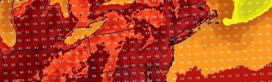
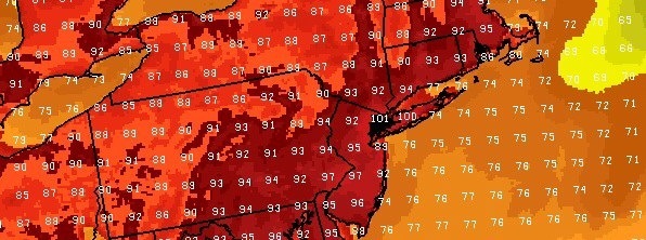
It has been a two week stretch of high dew points, fueled by a persistent West Atlantic ridge which has continually built towards the Eastern 1/3 of the US. Finally this morning, a frontal boundary pushed just off the area coasts helping to lower dew points with winds out of the northwest.

In addition, a cooler airmass aloft will settle into the area late this week with high temperatures falling into the 70s and lower 80s. The break in hot and humid weather may be somewhat short lived, but should still feel enjoyable.

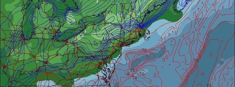
Forecast models have been hinting at the potential for showers late this week, despite the cooler airmass, with a weak coastal system moving offshore. Thereafter, temperatures should return to near normal levels by this weekend — but chances of showers and storms may continue.

Dorian could form today: The NHC is carefully watching Tropical Depression 4 in the Eastern Tropical Atlantic this morning — and the system may soon form into Tropical Storm Dorian based on satellite appearance. The storm is forecast to continue on a slow westward heading over the next several days. Intensity forecasts remain rather low and the storm’s strengthening is expected to be mitigated at some point by strengthening atmospheric shear. Regardless, stay tuned for updates as the system continues its slow jog westward over the vast Tropical Atlantic waters.

Excessive heat peaks Friday

20130719-091918.jpg

A week characterized by excessive, in some cases record setting, heat will come to a climax on Friday as temperatures and dew points are maximized ahead of a cold front. West-southwesterly winds will reinforce an already moist and hot airmass – and temperatures are expected to climb near or over 100 degrees in much of the NYC Metro Area and New Jersey on Friday afternoon. The combination of this surface heating and staggeringly high dew points in the mid to upper 70’s will lead to Heat Index values as high as 100 degrees.

The National Weather Service has issued an Excessive Heat Warning for the entire NYC Metro Area through 8pm Friday. The aforementioned combination of heat and humidity will make this final day of the heat wave especially dangerous. Make sure to take all heat related precautions and be prepared for any heat related emergencies. Keep a close eye on the elderly, children and pets. Avoid prolonged exposure to the sun as well as outdoor exercise. Wear loose fitting and light clothing if possible. Most importantly — stay hydrated at all times.

Along the area shores, some relief is expected by late Friday afternoon as a seabreeze develops. Then, finally, later on Saturday a cold front will make its approach towards the area — and is expected to sweep out the excessive heat. Until then, however, try your best to stay cool!

Dangerous heat wave will peak late this week

20130717-112019.jpg

Wednesday marked Day 3 of a prolonged heat wave which has gripped the area this week. High temperatures of 90 or above have been widespread throughout the area on both Monday and Tuesday. The big story over the next few days, however, will be the quickly rising dew points.

Heat Index values on Tuesday, despite hot temperatures, only topped out in the upper 90s thanks to lower dew points. But Wednesday marks the first day of rising dew points — which will too out in the mid to upper 70s on Friday. The heat will be peaking around then as well, with highs closer to 100 expected on Thursday and Friday. The combination of the two could lead to the most oppressively hot days of the summer.

With heat index values expected to be well over 100 degrees, we encourage you to review heat related emergency preparations. Stay hydrated. Keep a close eye on the elderly, children and pets. And remember to limit outdoor activity and exposure to the sun if possible.


Looking Ahead:
Some relief is expected by this weekend, but not before more hazardous weather. A strong cold front approaching the area will bring the chance for widespread severe weather throughout the Northeast US on Saturday. The Storm Prediction Center has placed our area in a potential for organized severe weather on Day 4 (Saturday). Stay tuned for more details and analysis as the event draws closer.

Forecast: Dangerous heat wave begins

Monday marks the beginning of what will be an extended period of dangerous heat, as a heat wave grips much of the Northeast United States. Amidst an impressive mid level ridge (500mb heights at 600dm over the Ohio Valley) temperatures will rise into the mid to upper 90s throughout the area. Dew points rising towards 70 will complicate matters, as heat index values will approach or exceed 100 degrees.

The shore may not provide as much relief as usual, either, as west-northwest winds will at the very least mitigate a strong seabreeze from pushing inland. Warming ocean waters have been noted over the past several  days as well.
The National Weather Service continues a Heat Advisory for New Jersey, New York City Metro, Southeast New York and Connecticut through the middle of the week. Forecast models, additionally, indicate that the heat could continue through the end of the week and into the weekend.
As we look ahead to the weekend – the forecast doesn’t get any more pleasant. In fact, a cold frontal boundary approaching from the northwest will eventually run into this hot and highly unstable airmass. The result, not surprisingly, could be a widespread severe weather event. The Storm Prediction Center has already highlighted our area for potential organized severe weather next Saturday.
With an active and hazardous weather week forthcoming, we encourage you to stay tuned for further updates. We will be covering the heat and severe weather potential throughout. Stay cool!