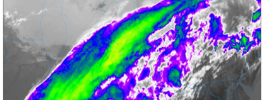
Happy Wednesday! More clouds and scattered showers are likely over the region, as a cold front and shortwave trough move through. Some weak instability could lead to some isolated thunderstorms and heavy downpours. There is a low chance that the Yankees vs Rays game in the Bronx could be delayed today. But most of this activity, may remain just north and west of NYC, where forcing is likely to be stronger.
https://www.nymetroweather.com/wp-content/uploads/2017/04/gfs_T2ma_neus_19.png7721024Miguel Pierrehttps://www.nymetroweather.com/wp-content/uploads/2024/02/Empire-2000-x-300-px-2.pngMiguel Pierre2017-04-12 10:55:462017-04-12 10:59:14All Zones Late AM Update: Cooler for Late Week, Warmer with Possible T-Storms Easter Sunday
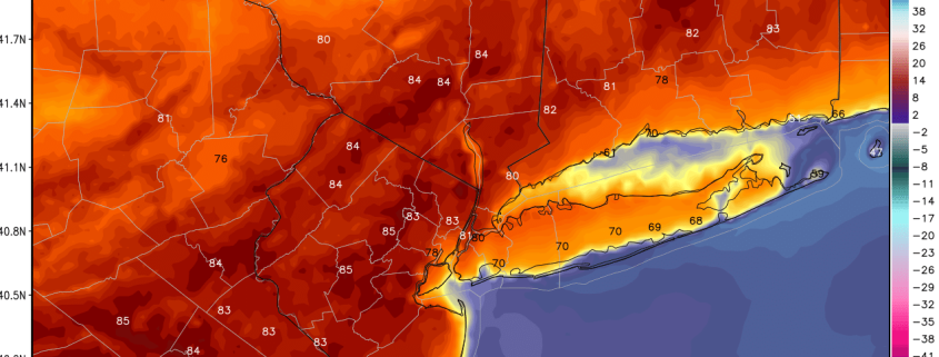
Good evening, everyone! Another lovely day was had today thanks to even more southwest flow than on Monday. High temperatures reached the mid 80s across much of the state of New Jersey!Areas further east were generally a bit cooler due to micro-scale breezes and large-scale synoptic southerly and southwesterly winds having more of a cooler, marine component for areas further east. EWR and TEB actually saw a bay-breeze as winds shifted SE off the Bay and cooled temperatures off in parts of Urban E NJ. Regardless, though, Newark still managed to reach a high of 82 degrees and NYC had a high of 80 degrees. JFK, however only had a high of 66 degrees and most of Long Island was generally in the upper 60s to around 70 degrees.
Dewpoints have already risen into the upper 40s to low to mid 50s in some spots thanks to the southwest flow. When combined with an increase in high clouds out ahead of some storms in Central PA associated with a pre-frontal trough ahead of a cold front, should lead to low temperatures holding in the 50s to even around 60 or higher in the warmer urban locations.
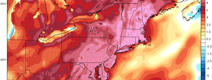
Good morning and Happy Tuesday! A taste of early summer weather in store for region today, as strong ridge continues to dominate over the region. Mostly sunny skies are expected today. A deeper southwest flow with 850mb temperatures 14°C to 15°C will support highs lower to middle 80s, much of NJ, NYC and the Lower Hudson Valley. Some records highs may be jeopardy across the region, including Newark at 87 and Central Park at 84, both from 1955. Meanwhile southwest winds and sea-breezes off the colder ocean and sound, will once again keep areas closer to coastline cooler in 60s to lower 70s for highs today.
https://www.nymetroweather.com/wp-content/uploads/2017/04/hrrr_t2m_max_nyc_12x.png7371274Miguel Pierrehttps://www.nymetroweather.com/wp-content/uploads/2024/02/Empire-2000-x-300-px-2.pngMiguel Pierre2017-04-11 10:30:302017-04-11 12:41:23AM All Zones Update: 80s Inland Today! Cooling Down Rest of the Week… Some T-Storms Easter Sunday?
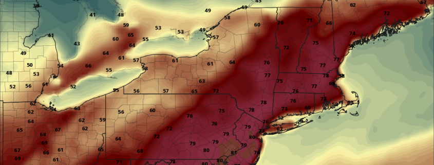
Good evening, everyone! We hope you enjoyed this beautiful Monday! Plenty of warmth was had in areas from NYC and west, with Newark tying a record high of 82 set in 1955. JFK, Long Island, and the Jersey Shore were much cooler due to the sea-breeze, but it was still a lovely day with plenty of sunshine and highs in the 60s. The rest of this evening looks quite pleasant and also milder than yesterday evening, as some moisture advection will prevent truly ideal radiational cooling conditions. Thus, low temperatures will generally hold around 50 or in the 50s for most of the region, with temperatures near 60 in urban areas. This will give us a nice head start for Tuesday’s warmth.
As we mentioned in yesterday’s PM article, the warmth is due to increased southwest flow in the atmosphere as the upper-level low from last week finally truly departs. This southwest flow will actually accelerate further on Tuesday, as a disturbance will be moving into SE Canada, which will increase the height gradient and thus accelerate the SW winds aloft, which will advect even warmer temperatures.
https://www.nymetroweather.com/wp-content/uploads/2017/04/17.png8501100Doug Simonianhttps://www.nymetroweather.com/wp-content/uploads/2024/02/Empire-2000-x-300-px-2.pngDoug Simonian2017-04-10 18:45:592017-04-10 18:59:18PM All Zones Update: Even Warmer Tuesday; Showers Wednesday
Hi friends! Our website uses cookies to provide an optimal browsing experience for you. New "Cookie Consent" laws mandate us to inform you of this. As long as you're cool with it, just hit OK. You'll only see this message once.
We may request cookies to be set on your device. We use cookies to let us know when you visit our websites, how you interact with us, to enrich your user experience, and to customize your relationship with our website.
Click on the different category headings to find out more. You can also change some of your preferences. Note that blocking some types of cookies may impact your experience on our websites and the services we are able to offer.
Essential Website Cookies
These cookies are strictly necessary to provide you with services available through our website and to use some of its features.
Because these cookies are strictly necessary to deliver the website, refusing them will have impact how our site functions. You always can block or delete cookies by changing your browser settings and force blocking all cookies on this website. But this will always prompt you to accept/refuse cookies when revisiting our site.
We fully respect if you want to refuse cookies but to avoid asking you again and again kindly allow us to store a cookie for that. You are free to opt out any time or opt in for other cookies to get a better experience. If you refuse cookies we will remove all set cookies in our domain.
We provide you with a list of stored cookies on your computer in our domain so you can check what we stored. Due to security reasons we are not able to show or modify cookies from other domains. You can check these in your browser security settings.
Other external services
We also use different external services like Google Webfonts, Google Maps, and external Video providers. Since these providers may collect personal data like your IP address we allow you to block them here. Please be aware that this might heavily reduce the functionality and appearance of our site. Changes will take effect once you reload the page.
-2")