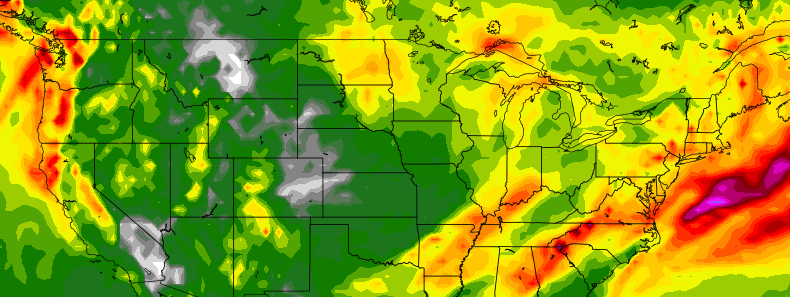
Heavy rainfall possible in the East next week

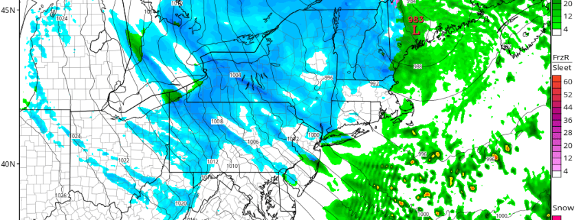
A significant storm system is expected to evolve throughout a large majority of the United States over the next several days — with heavy rainfall impacts possible throughout the Eastern US by the middle part of next week. Much of this would come as good news to the drought-ridden areas of the Eastern US, but the uncertainties in regards to the storm systems exact evolution make forecasting the system extremely difficult. Intricate processes at work will determine exactly where and when the heavy rainfall occurs.

The storm system forms initially over the next 48 hours as a strong disturbance evolves into the Plains states. A strong low pressure system at the surface develops rapidly northward into the Dakotas. Precipitation will spread eastwards towards the Corn Belt by early Monday morning as a front boundary surges eastward. But this initial disturbance is not the only feature of interest. While significant aloft, a second disturbance will move through the Rocky Mountain range during the early part of the week, eventually interacting with the initial storm.

Read more

Premium: Snow Squalls Possible on Sunday

Although we have generally been basked in a sea of warmth, we are getting to the time of year where snow becomes a more realistic possibility. A large storm system traversed the central part of the US, bringing blizzard conditions to the upper Plains and upper Midwest. While the pattern across most of North America has been pretty warm thanks to a raging Pacific Jet, this storm is powerful enough to tap into some cold air up north — while that air is not as cold as it “should” be this time of year, that air is still cold enough that if tapped into, could yield snow, if there is precipitation, of course.

Ahead of this storm, more warmth has moved into the Northeast, with high temperatures in the upper 60s today. A little bit more in the way of onshore flow is expected on Saturday, which may keep temperatures a tad cooler, but they still will be overall quite warm for this time of year — into the low to mid 60s. But part of this warmth stems from being ahead of a cold front, and once this cold front crosses, cold air advection will be taking place, but it will also be aided by a deepening secondary low pressure system, funneling in cold air from Canada and tapping into the aforementioned cold air.

Read more

Saturday Overview: Chilly Weather Today…Milder on Sunday

A colder airmass settled over the region, as expected overnight and this morning. But this airmass will be already on it way out this afternoon, as the pattern remains quite progressive. After quite a cold start with most of the area dropping into the 30s and some upper 20s, temperatures will rise into the upper 40s or lower 50s with plenty of sunshine this afternoon. Which is still chilly and somewhat below normal for November 12th. Strong and large high pressure centered over Ohio Valley will keep skies free today of much cloud cover through tonight.

Mostly clear skies and light winds will lead to more radiational cooling tonight. Especially for the suburbs, where lows will bottom upper 20s to middle 30s. Closer to NYC and urban areas lows will be upper 30s to lower 40s. On Sunday, more southwest winds with high pressure shifting south of the region, will support warmer high temperatures in upper 50s to lower 60s during the afternoon. More sunshine and dry weather will dominate throughout the day.  It should feel more pleasant than today! Some more highlights for early next week:

Read more

Friday Overview: Mild & Breezy Today, Quick Cold Blast Arrives Tonight

Temperatures this morning are already well into the 50s with west winds. As a strong cold front approaches, today from the northwest, temperatures will likely continue to rise into the lower or middle 60s over much of the region. But winds be increasing out the northwest by this afternoon with the front moving through the region. These winds could gust to between 30 to 40 mph at times. These winds will also help usher in a much colder airmass later tonight. Temperatures will begin falling through 50s and 40s later this afternoon and evening.

Winds will diminish overnight, as a cold airmass settles over the region. Many of the suburbs will get down into the middle 20s to lower 30s by dawn. The National Weather Service has issued Freeze Warnings for the parts of the area where growing season continues. Where a hard freeze and patchy frost is likely with vegetation. In NYC and some other urban areas temperatures are expected to drop into middle 30s with some pockets of frost possible by Saturday morning. Some other highlights for this weekend.

Read more