Meteorological winter is just one day away, and while snow lovers are beginning to get excited, much of the meteorological community is aware that the coming weeks are not likely to offer many wintry precipitation prospects. Our long range outlook will discuss the meteorological pattern for the upcoming 30 to 45 days. With an in depth look into meteorological patterns and the developing global circulations, we’ll explain the processes occuring that will drive our weather pattern through the month of December.
https://www.nymetroweather.com/wp-content/uploads/2015/11/longrange.png294868Miguel Pierrehttps://www.nymetroweather.com/wp-content/uploads/2024/02/Empire-2000-x-300-px-2.pngMiguel Pierre2015-11-30 11:04:132015-12-07 21:53:59Long Range Outlook: Active Pattern in December. But Will it Snow?
Welcome to our long-range outlook for the next 30-45 days. We hope to provide these outlooks with more in-depth analysis and discussion about every Monday and Thursday. The discussion is divided into several topics to cover all aspects of the model guidance and climate indicators.
For today, we discuss the overall pattern and what to expect going into late November and through much of December.
1. Model Guidance Discussion
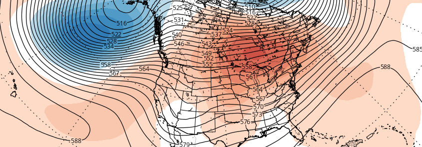
The 500mb pattern this week will feature a North Atlantic ridge being suppressed by a deep polar vortex developing over Greenland and Iceland. This is a classic +AO/NAO pattern that typically supports a strong ridge for the East Coast. A -EPO ridge forming over the the Northeast Pacific and Alaska will cause a trough to dig into the Western US. In response, a ridge will build over the Central and Eastern US.
https://www.nymetroweather.com/wp-content/uploads/2015/11/gfs-ens_z500a_namer_65.png6221024Miguel Pierrehttps://www.nymetroweather.com/wp-content/uploads/2024/02/Empire-2000-x-300-px-2.pngMiguel Pierre2015-11-23 19:48:132015-12-07 22:04:28Long-Range Outlook: Late November and December; December 1 Storm Threat
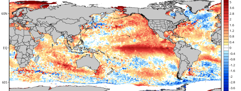
When a forecaster makes a seasonal outlook or forecast, he/she must consider all possible climate drivers and variables with teleconnections. Previous articles such as Monitoring the Stratosphere and The Importance of High Latitude Blocking in Upcoming Winter discussed the variables that were considered for our winter forecast, and how much weight was put into each. Now it’s time to look at some other climate patterns in Pacific. For example, this year’s strong El Nino is something you probably have heard the most about.
There is little doubt that a strong El Nino has a large influence over the atmospheric pattern in the Pacific Basin. Some have used the term “Godzilla El Nino” to describe this year’s phenomenon; which, while catchy, could perhaps be unneeded sensationalism. Another common thought is that after 1997-98 — the last “Super” El Nino, which was an extremely warm and snowless winter — that this winter will also be very warm and snowless in the Northeast. However, there are other climate patterns in the Pacific that can still have influence, even in the midst of such a strong El Nino, which makes such strongly-worded conclusions about this winter not justified.
https://www.nymetroweather.com/wp-content/uploads/2015/11/cdas-sflux_ssta_global_1.png5121024Miguel Pierrehttps://www.nymetroweather.com/wp-content/uploads/2024/02/Empire-2000-x-300-px-2.pngMiguel Pierre2015-11-16 11:00:012015-11-18 11:53:41The PDO, MJO and Their Potential Influence In This Upcoming El Nino Winter
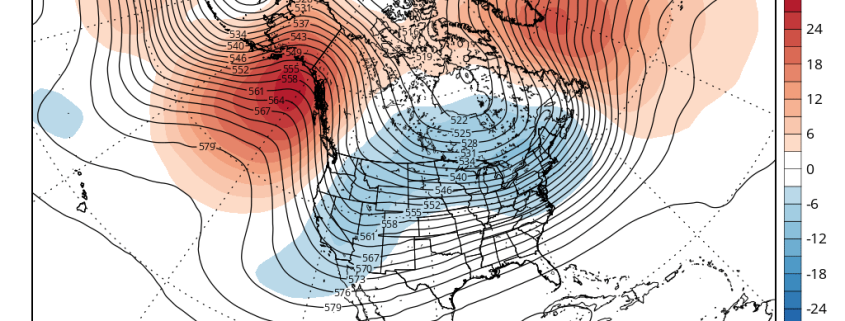
The days before Thanksgiving are some of the busiest travel days of the year, meaning that the weather has an even larger impact than usual. Accordingly, we have already been keeping an eye on model guidance for this period. While it’s still too far out to forecast with confidence, our November outlook did show some cooling to near average later this month, with an overall warm month in the means. Not coincidentally, there does appear to be some kind of pattern change on the model guidance that has piqued our interest.
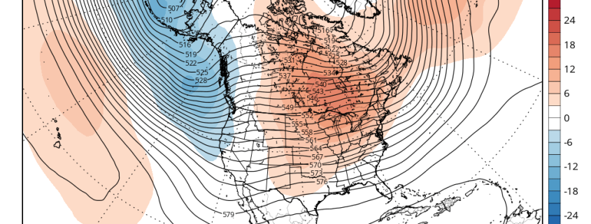
Forecast models and their ensembles have consistently showed above normal 500mb heights developing early next week over the Northeast Pacific. These heights extend up to Alaska, which causes the Eastern Pacific Oscillation (EPO) to go into its negative phase. Another ridge initially over the eastern US this will be forced to build into the Davis Strait and Greenland — temporarily bringing the North Atlantic Oscillation (NAO) down into its negative phase as well. This pattern will bring one or two cold shots into the Western and Central US on Thanksgiving week. The main questions are: a) will this airmass make it into the Eastern US, b) if so, how much (if any) modification will there be, and c) how long will this colder regime last?
https://www.nymetroweather.com/wp-content/uploads/2015/11/gfs-ens_z500a_namer_41.png6221024Miguel Pierrehttps://www.nymetroweather.com/wp-content/uploads/2024/02/Empire-2000-x-300-px-2.pngMiguel Pierre2015-11-16 09:00:142015-11-16 01:02:34An Early Look at the Pattern for Thanksgiving Week
Hi friends! Our website uses cookies to provide an optimal browsing experience for you. New "Cookie Consent" laws mandate us to inform you of this. As long as you're cool with it, just hit OK. You'll only see this message once.
We may request cookies to be set on your device. We use cookies to let us know when you visit our websites, how you interact with us, to enrich your user experience, and to customize your relationship with our website.
Click on the different category headings to find out more. You can also change some of your preferences. Note that blocking some types of cookies may impact your experience on our websites and the services we are able to offer.
Essential Website Cookies
These cookies are strictly necessary to provide you with services available through our website and to use some of its features.
Because these cookies are strictly necessary to deliver the website, refusing them will have impact how our site functions. You always can block or delete cookies by changing your browser settings and force blocking all cookies on this website. But this will always prompt you to accept/refuse cookies when revisiting our site.
We fully respect if you want to refuse cookies but to avoid asking you again and again kindly allow us to store a cookie for that. You are free to opt out any time or opt in for other cookies to get a better experience. If you refuse cookies we will remove all set cookies in our domain.
We provide you with a list of stored cookies on your computer in our domain so you can check what we stored. Due to security reasons we are not able to show or modify cookies from other domains. You can check these in your browser security settings.
Other external services
We also use different external services like Google Webfonts, Google Maps, and external Video providers. Since these providers may collect personal data like your IP address we allow you to block them here. Please be aware that this might heavily reduce the functionality and appearance of our site. Changes will take effect once you reload the page.
-2")