Most of the region saw their coolest temperatures of the fall-season this morning. However, urban areas did not — the most extreme examples of the discrepancy were lows of 29 and 32 degrees at Westhampton Beach Airport, NY (KFOK) and Somerset Airport, NJ (KSMQ) respectively, while Central Park (KNYC) and LaGuardia Airport (KLGA) had lows of 50 and 52, respectively. There are often temperature differences between urban and suburban/rural areas, but not of this magnitude. The phenomenon is not without precedent, however, and once explained — it actually makes a ton of sense.
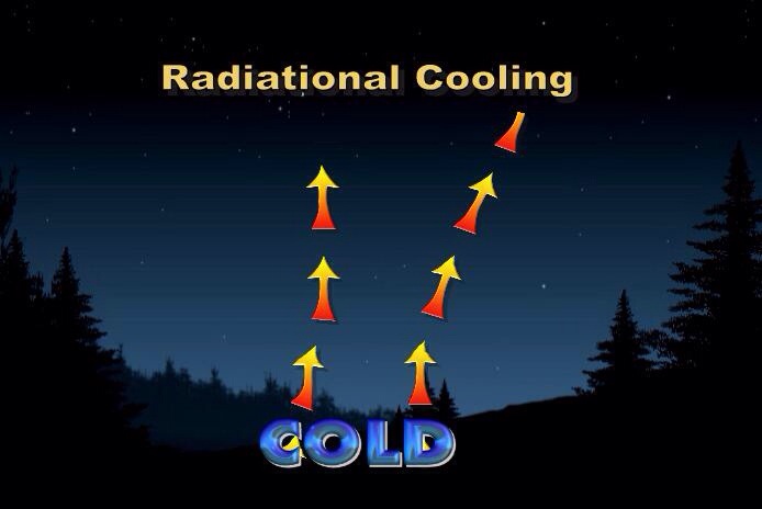
What do we know, to start, about radiational cooling? For one, we know that everything radiates heat. During the daytime hours, the suns incoming radiation serves as a heat source. But with nightfall, and the loss of daytime heating, the surface will continue to radiate the days heat outward — and cool. This is called, by definition, radiational cooling.
As we have alluded to in previous articles, the weather pattern across the globe is currently undergoing changes. A lot of this has to do with recurving Typhoon Wipha, as the large storm generated a trigger to produce a large ridge ahead of it. This helps to create a more amplified pattern, slowing things down. A slower global pattern is what tends to lead to more blocking, and the blocking that we are seeing this month could be a very important player as we head towards winter.
The reason it’s important is because there is a significant correlation — especially recently — between a -NAO in October and a -NAO during the following winter. One reason among many for this is because a -NAO pattern will often establish itself in October, relax a bit during November, and then re-establish itself during the winter. Our previous article highlights the detailed research and correlations, which will help you contextualize what is being written in this article.
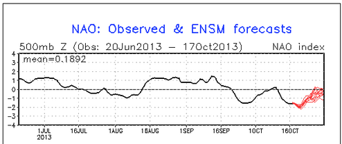
The prudent question to ask now would be how the NAO has been doing so far, and if it will stay negative for the rest of the month.
The NAO has been negative this month, and should continue to remain negative for the rest of the month. The black line represents the observed values, and the red lines represent the forecast values from the GFS ensembles.
https://www.nymetroweather.com/wp-content/uploads/2024/02/Empire-2000-x-300-px-2.png00Doug Simonianhttps://www.nymetroweather.com/wp-content/uploads/2024/02/Empire-2000-x-300-px-2.pngDoug Simonian2013-10-17 15:00:152013-10-17 18:09:24Update: October NAO and what it means for winter
As Autumn has arrived, the jet stream tends to get a bit stronger and sag to the south, helping make nor’easters more likely. Some computer model guidance had been hinting at a strong coastal storm approaching the area early next week, which would bring strong winds, heavy rain, and coastal flooding. However, the pattern does not support such an occurrence.
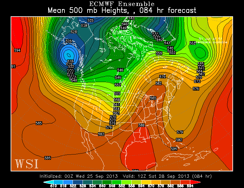
Looking at last night’s European model ensembles at the 500mb level, there do appear to be some features that support the potential for a strong nor’easter to head towards our area. Initially, there is a kink in the heights at 500mb just offshore of the Eastern Seaboard, which indicates our storm system. With strong storms like Sandy, we had a blocking ridge near and to the north of the storm, forcing it to stay to offshore of the southeast coast, instead of shooting out to sea. We also had a trough diving into the Central Plains, heading eastward, eventually capturing the storm and bringing it to the west. At the basic level, those two features certainly exist, which raise an eyebrow.
Last night’s European model ensembles, valid for 8 a.m. Saturday morning. Image is courtesy of the WSI model lab.
However, taking a deeper look at things, it is not prudent to say that a storm will trek towards us. For one thing, although there is a strong ridge in the east, extending up through SE Canada and New Foundland, it is merely a function of being downstream of the trough, and is not a block. Blocking typically occurs in higher latitudes — such as Greenland — and the height contours are typically closed. The true blocks are very slow to move and act to buckle the weather pattern, rather than being within the “flow” of the pattern. Since the ridge is merely downstream of the trough — it is within the “flow” of the pattern, and there is nothing to keep this ridge in place. It is thus a transient feature, and will eventually scoot out to sea and weaken. In fact, looking the higher latitudes, the heights are actually very low up there; more evidence that there is no true blocking.
https://www.nymetroweather.com/wp-content/uploads/2024/02/Empire-2000-x-300-px-2.png00Doug Simonianhttps://www.nymetroweather.com/wp-content/uploads/2024/02/Empire-2000-x-300-px-2.pngDoug Simonian2013-09-25 16:23:042013-09-26 01:11:28Why next week’s storm will not affect our region
Autumn began just a few days ago, but the weather pattern has already adjusted to the fall-like pattern with temperatures falling into the 30’s and 40’s at night. The first cold nights of the year typically come in mid to late September, as the warm and humid days of summer fade. The cooler, more crisp air gives us the first small taste of the cold winter which is only a handful of weeks away. The pattern has begun its seasonal change, and we are beginning to feel the effects of it. Yet, the best hints of what the winter pattern may have in store for us may be hundreds and thousands of miles to our north — over the high latitude/arctic region.
Seasonal forecasting can be a tedious and intricate task for meteorologists. Many times, meteorologists and forecasters alike find themselves drawing upon past events, analogs, and other research for help with predicting the months ahead. This is especially true in the Autumn season, as winter forecasting begins. Meteorologists are about to enter a flurry of forecasting over the next few months (yes, we are somehow enjoying this benign and calm weather right now). So as we look forward to the winter, we can often use the preceding months as indicators of the pattern to come. The pattern itself can often tip its hand, giving us a clue as to what we may be dealing with a few months down the road.
The words “high latitude blocking” likely will instantly bring back memories of some of our stronger storms and more volatile weather patterns in recent memory. The Blizzard of 2010, Hurricane Sandy, the Nor’Easter just a few weeks afterward. They all occurred during episodes of high latitude blocking, with a negative NAO cor North Atlantic Oscillation (for a background and more information on the NAO, click here). Still, high latitude blocking episodes which occur months before these events can often serve as accurate predictors, foreshadowing in a sense, of the upcoming pattern a few months after. A few months ago, we published some research on the blocking pattern during the month of May helping to predict the pattern during the summer months.
For a bit of reference, high latitude blocking refers to blocking ridges which occur in the higher latitudes over Canada and the North Atlantic (background on atmospheric blocking can be found here). These ridges slow down the jet stream/weather pattern. The high latitude blocking over Greenland, the North Atlantic, or Canada during the winter months often leads to the displacement of very cold arctic air over the United States, very often the Northeast US. The more amplified/slower pattern also leads to the potential for large coastal storm systems and has historically featured snowier and colder periods in the Northeast US.
https://www.nymetroweather.com/wp-content/uploads/2024/02/Empire-2000-x-300-px-2.png00John Homenukhttps://www.nymetroweather.com/wp-content/uploads/2024/02/Empire-2000-x-300-px-2.pngJohn Homenuk2013-09-25 10:00:062013-09-25 10:00:06October blocking could hint at winter pattern
Hi friends! Our website uses cookies to provide an optimal browsing experience for you. New "Cookie Consent" laws mandate us to inform you of this. As long as you're cool with it, just hit OK. You'll only see this message once.
We may request cookies to be set on your device. We use cookies to let us know when you visit our websites, how you interact with us, to enrich your user experience, and to customize your relationship with our website.
Click on the different category headings to find out more. You can also change some of your preferences. Note that blocking some types of cookies may impact your experience on our websites and the services we are able to offer.
Essential Website Cookies
These cookies are strictly necessary to provide you with services available through our website and to use some of its features.
Because these cookies are strictly necessary to deliver the website, refusing them will have impact how our site functions. You always can block or delete cookies by changing your browser settings and force blocking all cookies on this website. But this will always prompt you to accept/refuse cookies when revisiting our site.
We fully respect if you want to refuse cookies but to avoid asking you again and again kindly allow us to store a cookie for that. You are free to opt out any time or opt in for other cookies to get a better experience. If you refuse cookies we will remove all set cookies in our domain.
We provide you with a list of stored cookies on your computer in our domain so you can check what we stored. Due to security reasons we are not able to show or modify cookies from other domains. You can check these in your browser security settings.
Other external services
We also use different external services like Google Webfonts, Google Maps, and external Video providers. Since these providers may collect personal data like your IP address we allow you to block them here. Please be aware that this might heavily reduce the functionality and appearance of our site. Changes will take effect once you reload the page.
-2")