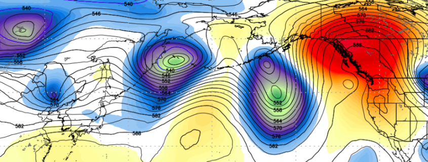
While much of the focus over the past few days has been on Hurricane Harvey, and rightfully so, another tropical cyclone will have an impact on the weather in the United States. We have spoken many times in the past regarding the importance of re-curving typhoons in the Pacific Ocean. These tropical systems can have major impacts on the mid level atmospheric patterns there, which eventually results in changes downwind over the United States.
https://www.nymetroweather.com/wp-content/uploads/2017/08/Screen-Shot-2017-08-29-at-8.41.23-PM.png3521065John Homenukhttps://www.nymetroweather.com/wp-content/uploads/2024/02/Empire-2000-x-300-px-2.pngJohn Homenuk2017-08-29 20:42:462017-08-29 20:42:46Cool risks exacerbated by recurving typhoon in the Western Pacific
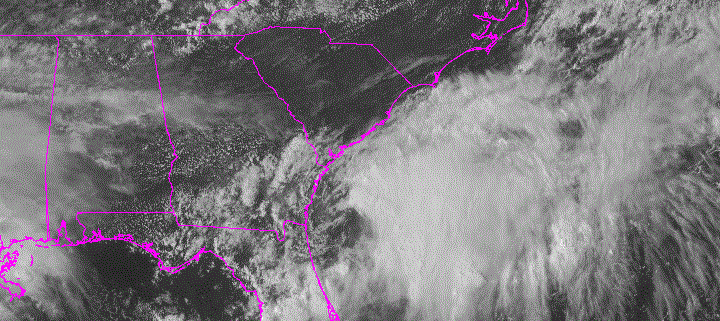
Good afternoon! Our forecasting team continues to monitor Potential Tropical Cyclone Ten, currently sitting off the South Carolina coast. The system still looks lacks a well-defined center of circulation this afternoon. However, deep convection has increased around and east of the center. It still possible that storm will gain enough organization for it to be classified as tropical depression or Tropical Storm Irma tonight or Tuesday. Tropical Storm Warnings have now been issued for parts of the North Carolina coast.
The storm is still underneath some strong west-southwesterly shear. If this becomes a tropical cyclone, it’s unlikely that this system will intensify into a hurricane before becoming a non-tropical storm or Nor’easter by Tuesday night or Wednesday off the Delmarva. Regardless of classification, potential impacts are not likely to change along the Mid-Atlantic and Southern New England Coasts. Heavy rainfall will likely spread northward over Eastern North Carolina and Southeast Virginia later tonight. Rainfall totals between 2” to 4” with locally higher amounts are likely. East-northeast winds will likely gust to tropical storm force between 40mph and 60mph.
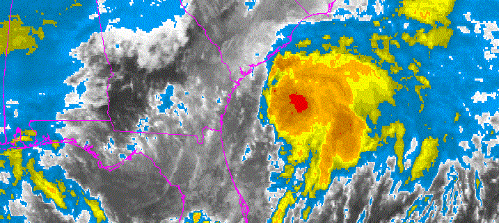
Plenty of attention has been on Harvey this weekend making landfall as a major Category 4 hurricane near Rockport, Texas, and then causing catastrophic flooding in and near the Houston Metropolitan area. This will likely not change over the next several days, as Harvey continues to meander over South Texas, dumping waves of heavy rainfall. But another storm is beginning to take shape off the Southeast Coast. This storm has been classified by the National Hurricane Center as Potential Tropical Cyclone Ten, which was previously invest 92L that was followed since it was way out in the Atlantic. Wind shear and dry air over much of the Western and Central Atlantic had kept this system from organizing. However, this system has become better organized just off the South Carolina and Georgia coasts this afternoon.
https://www.nymetroweather.com/wp-content/uploads/2017/08/PTC10visible.gif375720Miguel Pierrehttps://www.nymetroweather.com/wp-content/uploads/2024/02/Empire-2000-x-300-px-2.pngMiguel Pierre2017-08-27 18:22:422017-08-27 18:52:00Potential Tropical Cyclone Ten: Significant Impacts in the Carolinas Possible
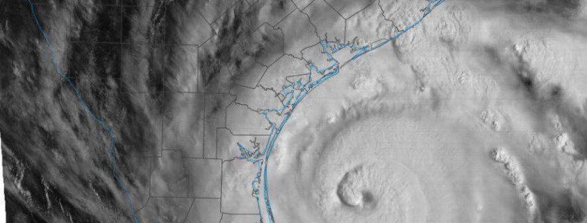
About six days ago, our forecasting team got together to discuss the possibility of tropical development in the Gulf of Mexico. After some debate, we decided to push an update out to clients that detailed the potential for Harvey — then an open wave — to regenerate into a tropical storm again and pose a threat to the Gulf Coast, perhaps reaching minimal hurricane strength. However, we never could have imagined, at the time, that the situation would become this dire or significant, as Harvey rapidly intensified from a tropical depression into a category 2/3 borderline hurricane over the past 24-36 hours. It’s usually quite difficult for an open wave to rapidly intensify after days of weakening over the Yucatan Peninsula. But Harvey defied those odds, which will result in devastating impacts.
Hurricane Harvey continued to strengthen slowly this morning, with the pressure slowly dropping into the 940mbs. As of 11am maximum sustained winds were still at 110mph, just underneath Category 3 strength. The hurricane continues to move north-northwest with outer rain bands now reaching the Texas Coast, with some tropical storm force winds. Harvey is expected to continue to intensify today into a major hurricane, while it moves over very warm sea-surface temperatures and heat content over the Western Gulf of Mexico, with a continued very favorable mid-upper atmosphere for strengthening.
Hi friends! Our website uses cookies to provide an optimal browsing experience for you. New "Cookie Consent" laws mandate us to inform you of this. As long as you're cool with it, just hit OK. You'll only see this message once.
We may request cookies to be set on your device. We use cookies to let us know when you visit our websites, how you interact with us, to enrich your user experience, and to customize your relationship with our website.
Click on the different category headings to find out more. You can also change some of your preferences. Note that blocking some types of cookies may impact your experience on our websites and the services we are able to offer.
Essential Website Cookies
These cookies are strictly necessary to provide you with services available through our website and to use some of its features.
Because these cookies are strictly necessary to deliver the website, refusing them will have impact how our site functions. You always can block or delete cookies by changing your browser settings and force blocking all cookies on this website. But this will always prompt you to accept/refuse cookies when revisiting our site.
We fully respect if you want to refuse cookies but to avoid asking you again and again kindly allow us to store a cookie for that. You are free to opt out any time or opt in for other cookies to get a better experience. If you refuse cookies we will remove all set cookies in our domain.
We provide you with a list of stored cookies on your computer in our domain so you can check what we stored. Due to security reasons we are not able to show or modify cookies from other domains. You can check these in your browser security settings.
Other external services
We also use different external services like Google Webfonts, Google Maps, and external Video providers. Since these providers may collect personal data like your IP address we allow you to block them here. Please be aware that this might heavily reduce the functionality and appearance of our site. Changes will take effect once you reload the page.
-2")