A wonderful Tuesday morning to you, and thank you for joining us for our daily morning roundup. If you haven’t checked your email box for the latest details, we will (as always) lay them out in an understandable post-based format here. Today we’re jumping straight into discussion regarding the cooler risks in the weather pattern over the Central United States as well heightened tropical risks across the Western Gulf of Mexico late week and into the weekend.
https://www.nymetroweather.com/wp-content/uploads/2017/08/Screen-Shot-2017-08-21-at-10.27.57-PM.png385725John Homenukhttps://www.nymetroweather.com/wp-content/uploads/2024/02/Empire-2000-x-300-px-2.pngJohn Homenuk2017-08-22 05:30:432017-08-22 08:45:59Cooler risks, Harvey concerns over the next week
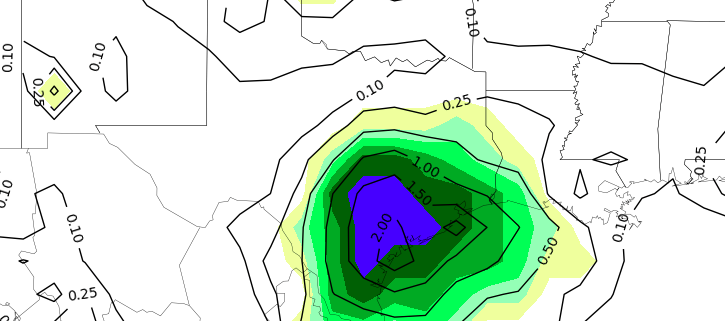
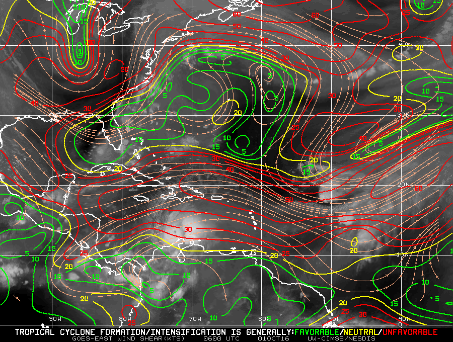
Good evening! During a quiet Tuesday afternoon weather-wise throughout a large majority of the Central and Eastern United States, attention has turned to the tropics. Tropical Storm Franklin continues to move towards the Yucatan and Invest 99L, a tropical wave well out in the Central Atlantic Ocean, continues a slow movement northwest. But how much of a threat do either of these systems pose to the U.S Mainland, specifically 99L? Lets clear the air, discuss the synoptics, and shed any misconceptions about tropical threats over the next week or so.
https://www.nymetroweather.com/wp-content/uploads/2017/08/Screen-Shot-2017-08-08-at-5.33.56-PM.png364930Miguel Pierrehttps://www.nymetroweather.com/wp-content/uploads/2024/02/Empire-2000-x-300-px-2.pngMiguel Pierre2017-08-08 18:38:392017-08-08 18:38:39The latest on Invest 99L and a look toward its future
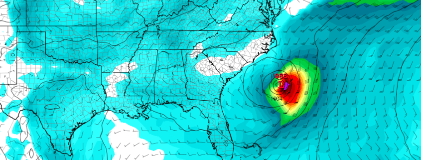
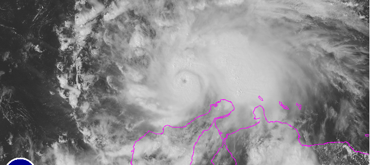
Hurricane Matthew continues to churn in the Caribbean this morning, and after briefly obtaining Category 5 strength this weekend, has steadily maintained Category 4 strength with winds near 145 miles per hour. Matthew was the first Category 5 hurricane in the Atlantic Ocean in 9 years, making the storm significant in its own right before it made any landfall. But exactly where the storm tracks over the next several days will determine its legacy — and some forecast models continue to suggest that we may remember the storm for a landfall on U.S soil.
The pattern dictating where Matthew goes, however, is complicated. As it stands this morning, steering currents around Matthew are quite weak. They’ve been that way for a few days now, and not surprisingly Matthew has lingered, wobbled, and meandered in the warm waters of the Central Caribbean. He will begin a notable northward turn today, however, and as he moves northward toward more favorable mid and upper level winds, the storm is expected to pass dangerously close to the islands of Jamaica, Haiti, and Cuba. Forecast models currently suggest Matthew is most likely to track on the Eastern Shores of Cuba before re-emerging into the borderline hot waters of the Bahamas.
https://www.nymetroweather.com/wp-content/uploads/2016/10/matthewhead.png355774John Homenukhttps://www.nymetroweather.com/wp-content/uploads/2024/02/Empire-2000-x-300-px-2.pngJohn Homenuk2016-10-03 09:29:182016-10-03 09:29:18The latest on Hurricane Matthew and his uncertain fate
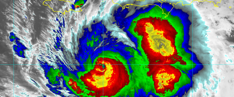
Matthew unexpectedly underwent rapid intensification to category 5 hurricane on Friday. This is despite between 20-30kts southwesterly shear over the eye. Today, Matthew has slightly weakened down to category 4 hurricane. But still remains a very powerful and dangerous hurricane. Matthew has been moving very slowly west-southwestward over the Central Caribbean. But is expected to make gradual turn northward later tonight and Sunday. This will take the eye somewhere between Jamaica, Eastern Cuba and Haiti Bahamas by Monday. Then somewhere over the Bahamas by Tuesday and Wednesday. So will Matthew turn towards the United States or will go out to sea? Well alot depends how it interacts with incoming trough and how strong the ridge is over the Western Atlantic.
https://www.nymetroweather.com/wp-content/uploads/2016/10/Visible.png481723Miguel Pierrehttps://www.nymetroweather.com/wp-content/uploads/2024/02/Empire-2000-x-300-px-2.pngMiguel Pierre2016-10-01 18:00:512016-10-01 22:58:41Hurricane Matthew’s Potential Impacts on the Caribbean and United States
Hi friends! Our website uses cookies to provide an optimal browsing experience for you. New "Cookie Consent" laws mandate us to inform you of this. As long as you're cool with it, just hit OK. You'll only see this message once.
We may request cookies to be set on your device. We use cookies to let us know when you visit our websites, how you interact with us, to enrich your user experience, and to customize your relationship with our website.
Click on the different category headings to find out more. You can also change some of your preferences. Note that blocking some types of cookies may impact your experience on our websites and the services we are able to offer.
Essential Website Cookies
These cookies are strictly necessary to provide you with services available through our website and to use some of its features.
Because these cookies are strictly necessary to deliver the website, refusing them will have impact how our site functions. You always can block or delete cookies by changing your browser settings and force blocking all cookies on this website. But this will always prompt you to accept/refuse cookies when revisiting our site.
We fully respect if you want to refuse cookies but to avoid asking you again and again kindly allow us to store a cookie for that. You are free to opt out any time or opt in for other cookies to get a better experience. If you refuse cookies we will remove all set cookies in our domain.
We provide you with a list of stored cookies on your computer in our domain so you can check what we stored. Due to security reasons we are not able to show or modify cookies from other domains. You can check these in your browser security settings.
Other external services
We also use different external services like Google Webfonts, Google Maps, and external Video providers. Since these providers may collect personal data like your IP address we allow you to block them here. Please be aware that this might heavily reduce the functionality and appearance of our site. Changes will take effect once you reload the page.
-2")