Hurricane Floyd still a fresh memory after 15 years

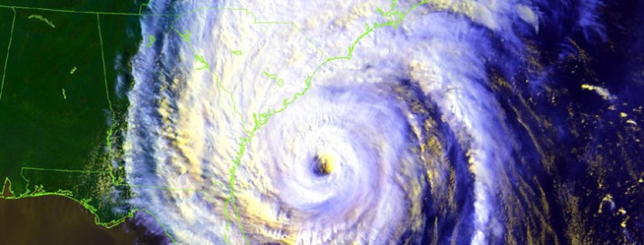
Hurricane Floyd, although it was a Tropical Storm by the time it reached our area, left a lasting impact on much of the United States East Coast. Although the memories of many in our area are fogged by the tremendous damage from Hurricane Sandy, Floyd brought it’s own slew of effects 15 years ago today. The storm left an incredible amount of flooding in New Jersey — and while high winds and beach erosion weren’t major concerns –multiple deaths and millions of dollars in damage occurred.

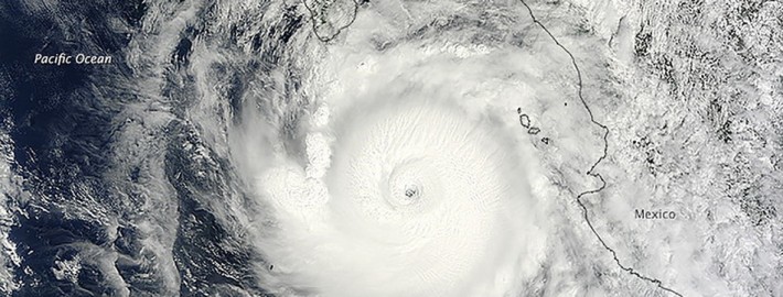
Unlike Sandy the main story with Floyd was, as aforementioned, heavy rain. The storm developed in the Atlantic several days before impacting the United States East Coast and then strengthened into a hurricane. Eventually, Floyd peaked as a Category 4 storm as it struck the Bahamas. The storm then began to turn northward and eventually began interacting with a mid level system from the Central United States into the Ohio Valley. Similarly to Hurricane Sandy, the phase between these two systems tugged the Tropical Storm toward the Mid-Atlantic coast.

Read more

Pictures, videos of Hurricane Odile slamming Mexico

Hurricane Odile slammed into the Baja Peninsula this weekend, tied for the strongest hurricane ever to impact them in recorded history. The powerful storm was packing sustained winds of 125 miles per hour with with higher gusts as its center passed extremely close to Cabo San Lucas on Sunday Night. The storm has weakened today, but is still churning northwestward. Over the next few days, it will turn eastward as a result of mid level interactions in the atmosphere — and bring the potential for historical rains to parts of the Southwestern United States — Nevada, Arizona and New Mexico.

Pictures and videos of the devastation from the hurricane’s impact along the Baja Peninsula are being posted, submitted and shared at an increasing volume this afternoon. Some of them are compiled below — and we’ll continue to add them as we receive them over the next few days.

Read more

Severe thunderstorms again today, Arthur a ‘Cane

Severe thunderstorms rocked the NY/NJ area on Wednesday evening, owing to rich tropical moisture and strong atmospheric instability. Behind storms of that nature, typically, the airmass becomes less humid, cooler and drier. Thursday will be atypical in that sense, as tropical moisture will actually increase once again. Rising dew points and humidity values will continue — and temperatures in the 80’s and 90’s are expected again by early afternoon. And, again, an approaching mid level disturbance is expected to aid in the development of strong to severe thunderstorms by afternoon.

Storms will progress from southwest to northeast, initially forming in Pennsylvania and making their way through New Jersey. As was the case on Wednesday dangerous lightning, flash flooding, strong winds and small hail are all possible in strong to severe thunderstorms that do develop. The National Weather Service has issued a Flash Flood Watch for much of the region, and the Storm Prediction Center has placed the area in a Slight Risk for severe thunderstorms through this evening.

Todays Day 1 Outlook from the Storm Prediction Center showing a Slight Risk near our area.

Todays Day 1 Outlook from the Storm Prediction Center showing a Slight Risk near our area.

Read more

Heat and severe storms Wednesday, Arthur late week

UPDATE 2:00pm: A severe thunderstorm watch is in effect until 9:00pm this evening. The Storm Prediction Center suggests severe thunderstorms are possible, capable of producing strong winds, small hail, and dangerous lightning. Stay tuned for updates including any severe thunderstorm or flood related warnings. The latest information on the severe thunderstorm watch can be found here.

Heat Advisories were issued by the National Weather Service for much of New Jersey on Wednesday, as heat is expected to build throughout the area once again. Rising dew points are only adding to the issue — as they will create a much muggier, more oppressive airmass than the past few days this week. Heat index values are expected to rise well into the 90’s and possibly come close to 100 in some spots later this afternoon. Any time dew points rise into the mid 70’s while temperatures are in the mid 90’s — the air will be quite heavy.

In addition to the oppressive heat, strong to severe thunderstorms are possible this afternoon. The Storm Prediction Center has placed the area in a “Slight Risk” for severe thunderstorms, indicating a risk of small hail and strong winds. In addition to those threats, heavy rain and frequent lightning would be likely in any thunderstorms that develop. We encourage you to stay tuned throughout the day for updates on the developing thunderstorms and hazardous weather threat. In addition, stay hydrated and avoid prolonged outdoor exposure.

Day 1 Outlook from the SPC showing a Slight Risk throughout the area on Wednesday.

Day 1 Outlook from the SPC showing a Slight Risk throughout the area on Wednesday.

Read more