ECMWF Sunday 2am

Light Snow Friday Morning, All Eyes on This Weekend

Good Evening!

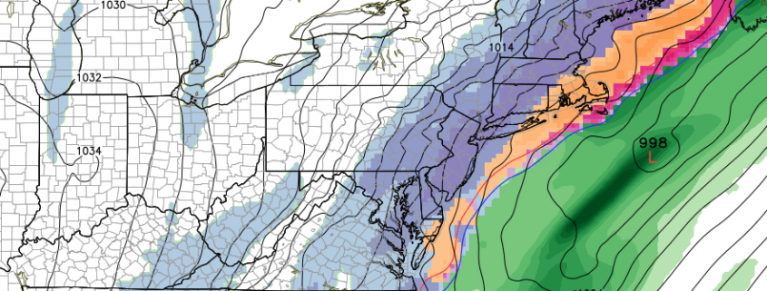
Today has been another calm and relatively cool day across much of the Northeast as high pressure remains in control of our sensible weather. Partly cloudy skies and mid-level flow coming out of the west allowed for temperatures to rise into the upper 30’s to lower 40’s for much of the NYC metro area, which is slightly above-normal for this time of year. A weak cold front is currently situated over portions of New York and Pennsylvania and has been gradually moving to the southeast during the course of the day. This cold front is expected to arrive later this evening, which will usher in a fresh batch of cold air into the region. There really isn’t much in the way of moisture associated with this front, so this will likely be another dry and cold night. Occasionally breezy conditions will set up behind the front with clearing skies from northwest to southeast tonight.

With a fresh cold air mass in place and clearing skies, radiational cooling will take over tonight, allowing temperatures to fall into the lower 20’s in and around the city, with teens possible for locations off to the north and west.

Simuawips

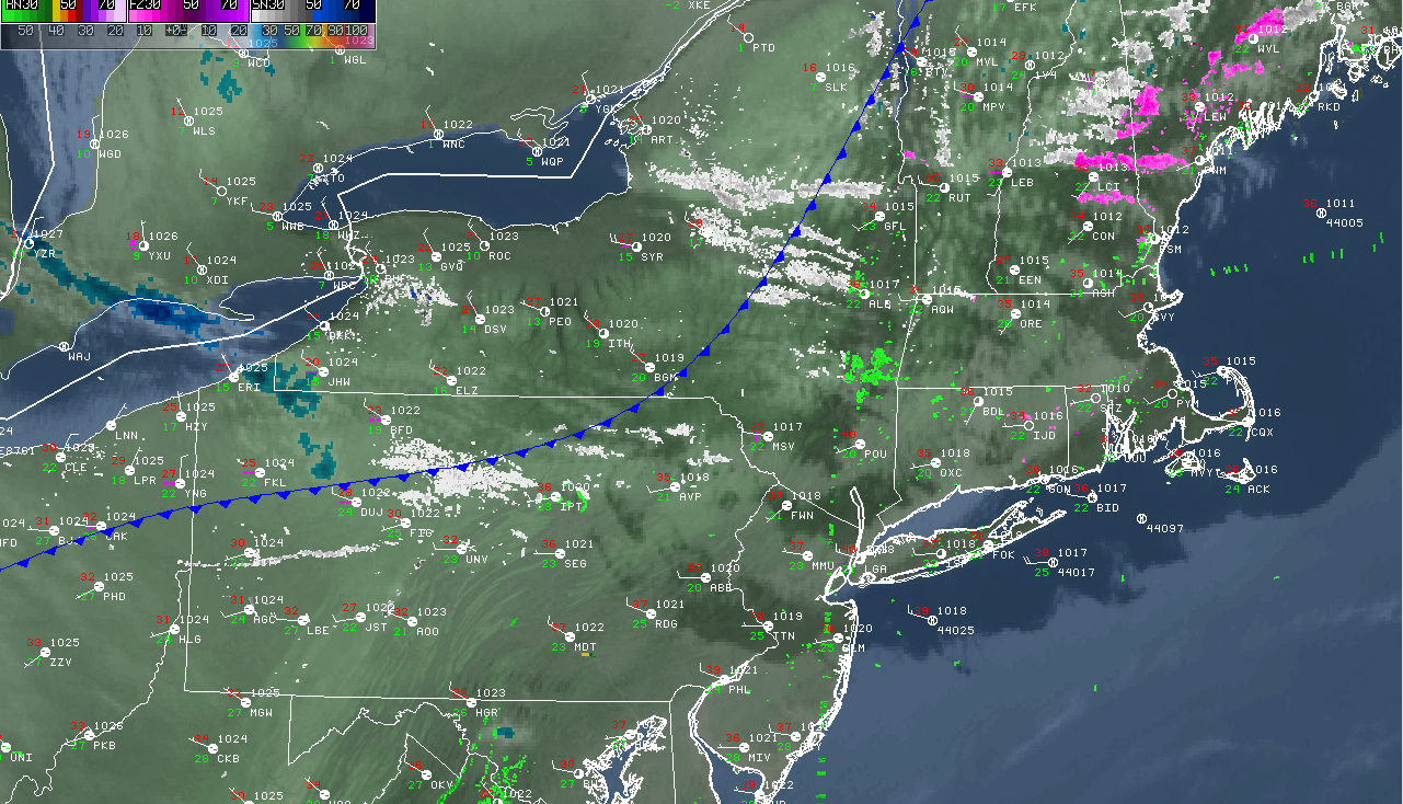
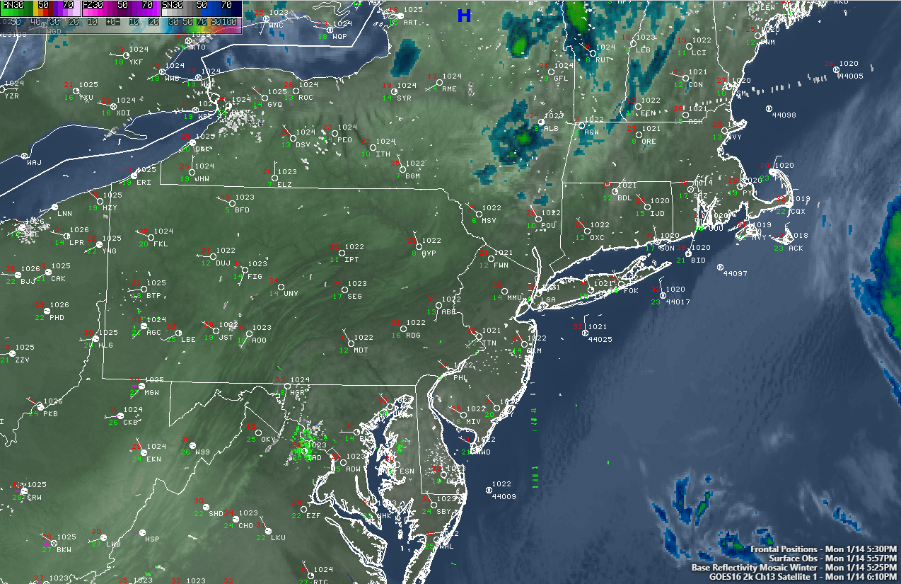
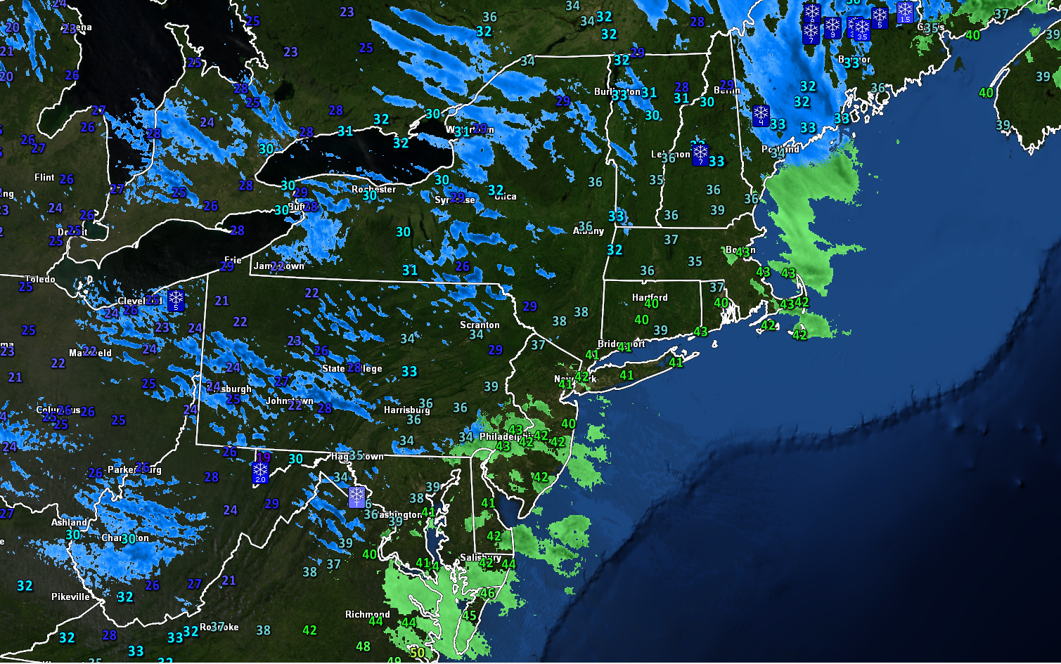
This evenings current radar and surface observations

Light Snow Likely Tomorrow Night and Into Friday Morning

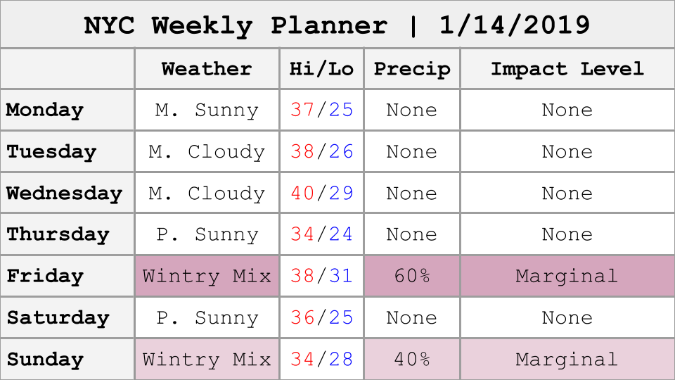
Tomorrow (Thursday) will likely start off quite chilly with temperatures in the lower 20’s for the immediate New York City metro area. Continued breezy conditions will yield wind chills in the teens for the entire area tomorrow morning, so it’s definitely going to feel quite cold for the morning commute. High pressure will remain in place for the majority of the day which will allow for partly sunny skies and gradually diminishing winds into the afternoon hours. Highs will likely be hard-pressed to rise above-freezing tomorrow afternoon, with locations to the north and west of the city likely staying in the middle to upper 20’s.

By the early afternoon hours, our attention will shift to the west over the Ohio Valley. A weak and disorganized mid-level wave will be quickly heading to the east during the day with an associated area of light snow. This system will continue to gradually move into our area tomorrow evening, with increasing clouds towards sunset. Cloudiness will continue to increase during the overnight hours as moisture to our south begins to overspread the area. Light snow will quickly move into the NYC metro area, likely around 2am or so. The entire forecast area will likely stay snow for the first couple of hours, but as moisture continues to trickle in from the south, warmer air will also be on the rise. Coastal locations will likely change over to a mix of rain and snow by 6am Friday, with locations to the north and west of NYC likely staying as light snow. Precipitation will quickly head off to our east by 8-10 am, with some residual spotty snow/rain showers remaining for the rest of the afternoon.

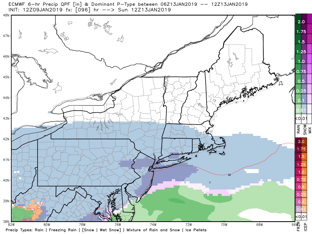
Due to the progressive nature of this system, marginal amounts of forcing, minimal precip amounts (.1″ to .25″ of liquid), and increasing surfaces temperatures, snow totals are expected to be low. At this time, a quick coating to an inch of snow will be possible in and around the immediate NYC area, especially on colder surfaces. Once we head off to the north and west, mainly 1-3″ of snow is expected–especially for elevated locations over NW NJ and SNY.

Due to the timing of this light snow event, it seems possible that some delayed openings may be called for portions of NW NJ and SNY. 

3KM NAM Simulated Radar

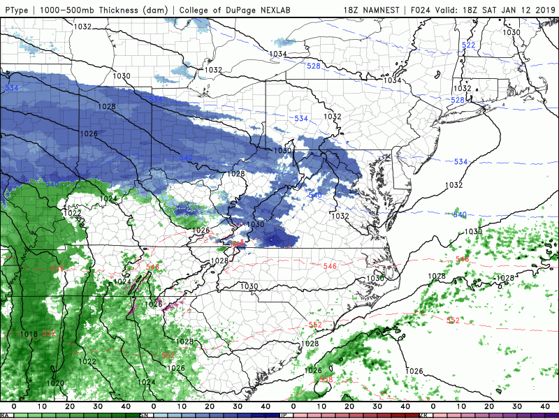
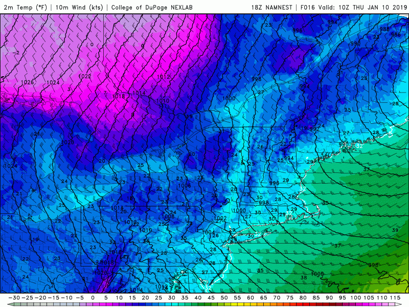
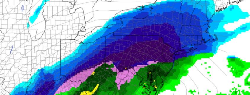
High resolution NAM simulated reflectivity showing the evolution of the light snow event tomorrow night and into Friday morning

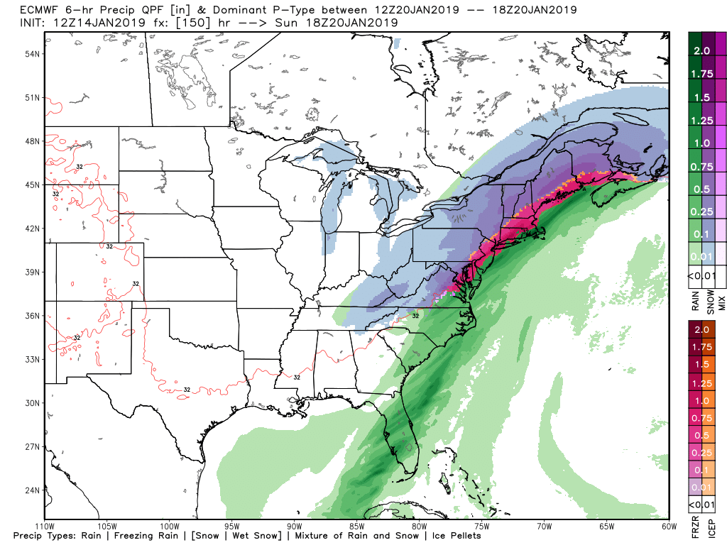
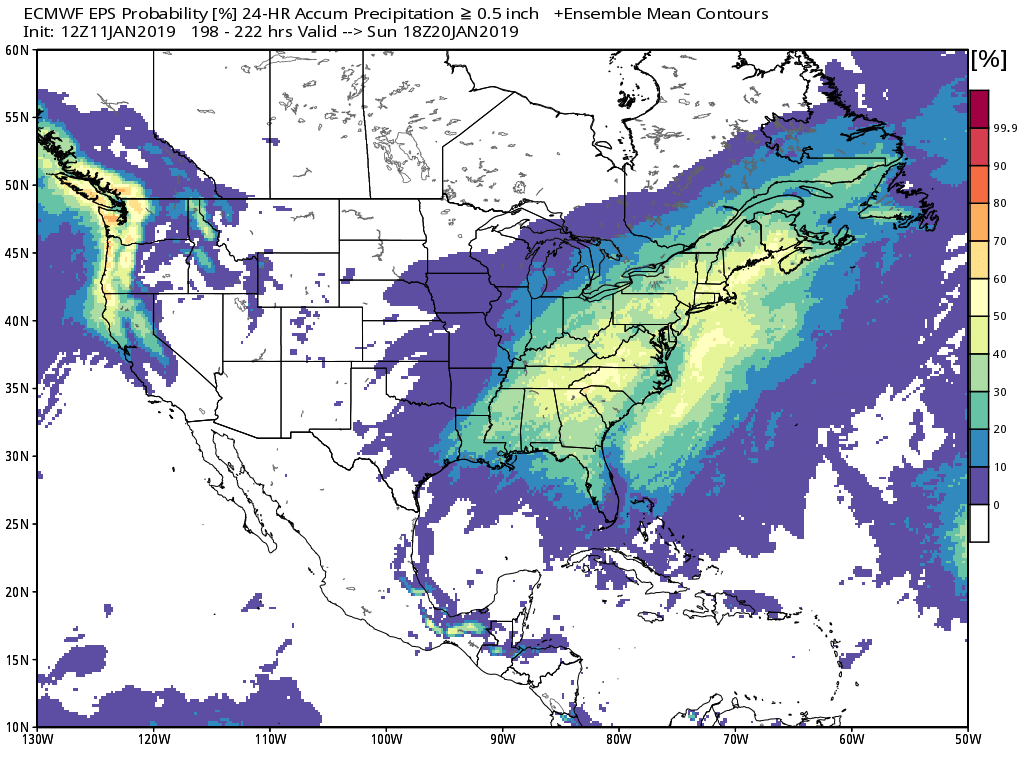
Potentially Impactful System Shaping Up for the Weekend

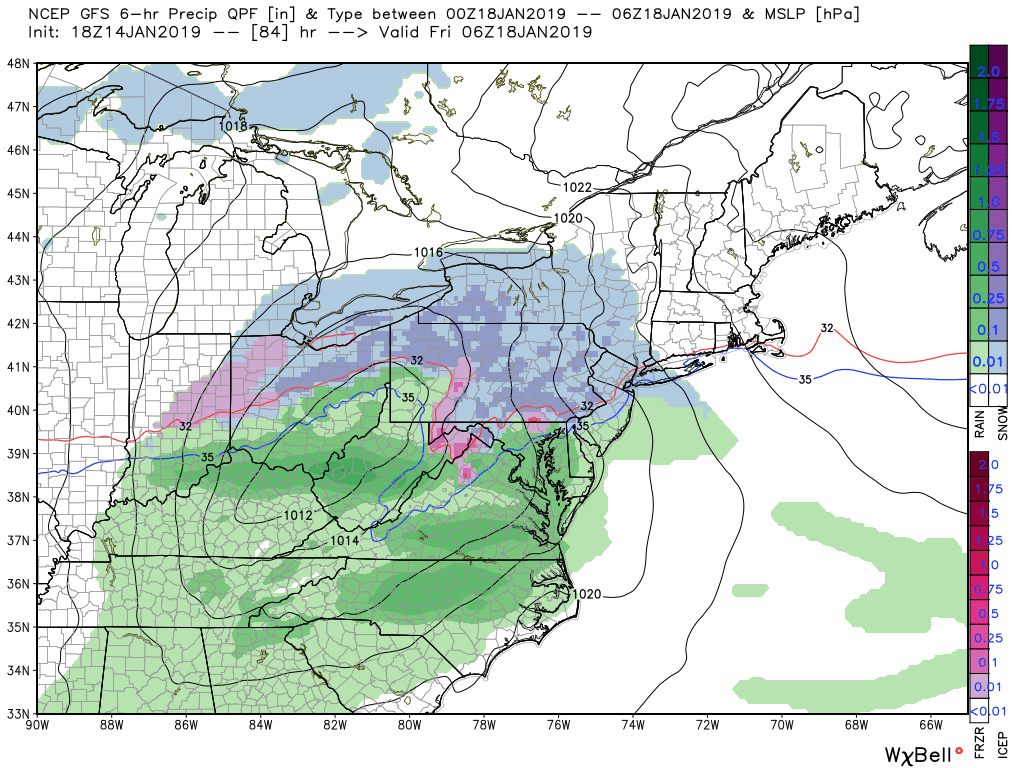
The overall setup for this weekends potential system has not changed much since our last update. A large and energetic system that is currently located off the California coast will move into the Rocky Mountains by Friday morning, producing an area of low pressure over the Southern Plains at the surface. As this energetic system begins to head east during throughout Friday and into Saturday morning, another large upper-level system located over Canada will begin to shift to the south. This large system over Canada will help to inject a massive amount of cold air into the Central US, leading to a large area of moderate to heavy snow developing over the Midwest on Saturday afternoon. Things become a little more hazy later in the day on Saturday as the western edge of the Canadian system tries to interact or phase with the shortwave over the Southern Plains/Midwest. This potential interaction will be absolutely crucial for the overall impact for much of the Northeast.

As of right now there are two main solution on the table:

  1. The system over Canada DOES interact and phases with the shortwave to its south late Saturday and into Sunday morning. This causes the surface low to gradually strengthen and track from the Southeast and eventually moves to the west of our area. While an initial thump of moderate to heavy snow would be possible for locations to the north and west of NYC, precipitation would then quickly flip to rain for the remainder of this storm. This solution would have a rather limited impact for our area, with heavy rains likely during the day on Sunday.
  2. The system over Canada DOES NOT interact with the southern stream system and misses the phase. This would allow for the surface low to move to the south and east of our area, bringing in much colder temperatures into the Northeast. A thump of moderate to heavy snow would be likely for most of the Northeast late Saturday night and into Sunday morning. Snow would potentially change to sleet and freezing rain from south to north during the day on Sunday as warmer air in the mid levels of the atmosphere moves over temperatures that are still below-freezing at the surface. This would create a potentially hazardous situation for the immediate NYC area, with a thick layer of ice on top of snow. In this scenario, locations to the north and west would have a good shot at staying mostly snow as cold air from the north rushes into the area. This solution would obviously have a much higher impact for all locations outside of the immediate coast.

This afternoons model guidance did trend towards a solution with less interaction between the Canadian system and the main shortwave, which allowed for some more cold solutions to show up. Additionally, the models have been advertising that the magnitude of cold air just to our north will be quite impressive Saturday night and into Sunday. This cold air will be very dense, and computer models usually tend to move this cold air out of the Northeast much too quickly, leading to an underestimate of frozen precip.

At this time we feel that the trends towards a less-phased system have merit, and there will likely be a period of moderate to heavy snow late Saturday and into Sunday. While there is a high amount of uncertainty regarding what happens after that point, snow could gradually flip over to freezing rain and rain during the day on Sunday for much of the area, which would open the potential for a hazardous solution. This scenario would have the majority of the impacts mainly to the north and west of the city.

**It is important to note that this system is still a couple days away and we will still likely see some significant changes in that time. We will continue to closely monitor the progress of this system and provide updates as new data becomes available!

Impact map

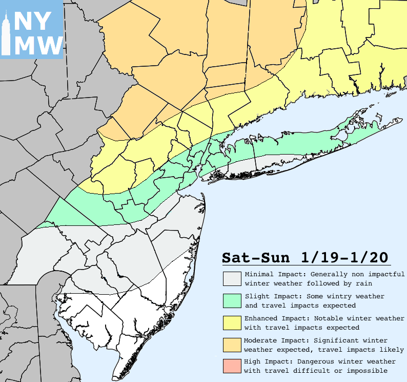
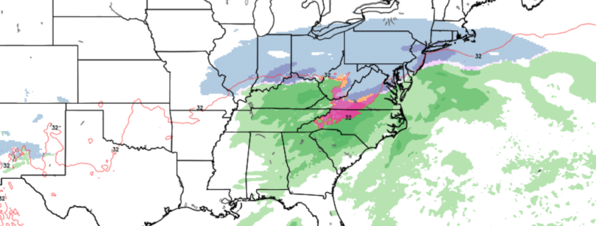
Impact map for this weekends system

Have a great night!

Steve Copertino

GFS

Watching Two Snow Threats Later This Week and Into the Weekend

Good Evening! 

Today has been quite cold and calm across much of the Mid-Atlantic and Northeast as the storm system that impacted much of the Central US to the Mid-Atlantic moved offshore very early this morning. High pressure has now begun to build in from the west in this system’s wake, ushering in colder mid-level temperatures from the Northwest. With cold mid-levels and mainly clear conditions in place today, highs were able to only reach into the upper 20’s to lower 30’s across much of the New York metro area-which is just slightly below-normal for this time of year.

Continued clear skies, cold mid-levels, and light winds will aid in the development of decent radiational cooling during the overnight hours. Low temperatures should drop steeply into the middle teens to lower 20’s across much of the forecast area tonight, with single-digit readings possible for elevated locations well off to the north and west of the city.

GOES 16 IR & Regional Radar

This evenings high-resolution regional radar and surface observations showing a cold, but very calm evening in place for much of the Northeast (Simuawips)

Cold and Clear Through Midweek

High pressure will remain in control for much of the day on Tuesday before a very weak and moisture-starved system begins to approach the Northeast from Canada. As this system approaches the area, lower to mid-level winds will shift from northwesterly to more westerly, allowing for only slightly “warmer” air to move in. This system may also have a chance to briefly increase cloudiness over the Northeast during the afternoon hours. Some slightly increased cloudiness and westerly flow aloft will likely allow for highs tomorrow to head into the middle 30’s to lower 40’s across much of the forecast area. While these temperatures are slightly warmer than today’s highs, they will still be right around normal for this time of year. As this weak system moves through moves through tomorrow afternoon/evening, there may be some light snow showers over portions of New York State and Northern Pennsylvania, but the entire New York metro area should remain dry. Once this system moves on through the area, a weak cold front will then quickly move from west to east, eliminating any remaining clouds in the area. With a relatively more mild airmass overhead tomorrow night, highs will likely only be slightly warmer than this evening’s, with readings in the upper teens to middle 20’s likely.

Wednesday will start off much like Tuesday with calm, clear, and cold conditions in place for the morning commute. Temperatures will be rather cold, with lower to middle 20’s likely for much of the immediate metro area. Another weak mid-level system will be moving very quickly well to our north on Wednesday afternoon, with the potential for some increased cloudiness over the area. Highs will reach the middle to upper 30’s, with lower 40’s likely closer to the coast.

The potential will exist for some light snow snow showers off to the north and west of the city on Wednesday afternoon/evening, but it is highly unlikely that these snow showers are able to make their way south into portions of New Jersey and New York City due to the best dynamics remaining well off to our north. As the evening continues on, another weak cold front will move through during the evening and overnight areas, bringing in another reinforcement of drier conditions. Wednesday night will likely be another cold and mostly clear night for the area, with lows dropping down into the lower to middle 20’s.

Weekly Planner

~Updated Weekly Planner for the NYC area~

Watching Two Potential Snow Threats Later This Week and Into the Weekend

Conditions will likely remain quite calm and cold through the middle of the week and into the first half of Thursday. However that looks to quickly change as we shift our attention towards the Ohio Valley. A weak northern stream disturbance will be moving quickly from west to east, with just enough moisture moving up from the south to produce a swath of light precipitation. Additionally, an area of high pressure will be located over New England, which should help this system continue on eastward towards the New York City area by Thursday evening. Light precipitation should move into the metro area by 7-9 pm, with most of the area starting as light snow. Initially, the aforementioned high pressure area should help the entire forecast area stay as mostly snow, with locations over Southern New Jersey possibly experiencing some mixing issues.

As we head deeper into the overnight hours, warmer air may continue to work its way into the immediate New York City area, causing a mix or change to rain. Precipitation will likely continue into the AM commute on Friday before quickly tapering off from west to east. At this time it does appear that this system could drop a quick coating to an inch or two across portions of the NYC metro area, with some locally higher amounts for elevated locations off to our north and west. The exact amount of snow/rain will be highly reliant on the track of this system, and we will have an update tomorrow as more data becomes available!

GFS

This evenings GFS model showing a weak disturbance producing an area of light snow over the Northeast late Thursday night and into Friday morning

Lastly, we mentioned the possibility of a “larger” system that could impact the East Coast this upcoming weekend all the way back on Friday. Since that time, the reliable computer model guidance has shifted away somewhat from a significant/pure-snowstorm, to more of a “thump” of moderate to heavy snow-along with a mix of sleet, freezing rain, and plain rain for much of the forecast area.

At this time we feel that the mostly likely scenario based on all available data is that another large storm system will develop over the Midwestern states on Friday night, with a large swath of moderate to heavy snow extending along the northern edge of the precipitation shield. This system will then have the potential to interact with a much larger mid-level system over Canada on Saturday, which will likely cause it to strengthen a bit as it tracks over the Southeast. A large and expansive upper level jet streak will help to “vent” this system out, allowing for precipitation to expand into the Northeast by Saturday afternoon. Thermal profiles appear to be cold enough for precipitation to start and stay as mostly snow for the NYC area during the afternoon and early evening hours. There is the potential that the snow could eventually change to a mix of sleet, freezing rain, or even plain rain by the overnight hours of Saturday or early Sunday, but this is where the models begin to diverge significantly. Depending on just how much this system interacts with the large tropospheric polar vortex over Canada will dictate just how much cold air can get involved and where exactly this system will track.

There is still quite a bit of time to track this system, and we could still see a shift towards either side (colder with more snow or warmer with more rain) over the next few days, so make sure to check back for updates!

ECMWF PTYPE

This afternoons ECMWF model showing a large area of wintry precipitation breaking out over the East Coast on Sunday

Have a great night!

-Steve Copertino

ECMWF total snowfall

Mid-Atlantic Snow, Cold Weather Holds Tight Into Next Week

Good Evening!

We have finally seen the return of more seasonable temperatures across much of the Mid-Atlantic and Northeast today as an Arctic high pressure system continues to dominate our sensible weather. Temperatures early this morning were in the teens to lower 20’s across much of the NYC metro area, which really brought a harsh reminder to many that we are still in the middle of January and it does get cold-despite the past few weeks of warmer temperatures. As we worked through the day today, temperatures were only able to rise into the middle to upper 20’s with some lower 30’s closer to the coast and over portions of Southern New Jersey-which is right around normal or just slightly below-normal for this time of year.

Continued clear skies and dry conditions will last well into the evening and overnight hours tonight which will set the stage for near-ideal radiational cooling conditions to take place. Temperatures will likely plummet once again back down into the teens for much of the forecast area, with lower to middle 20’s for portions of Southern New Jersey. Even with subsiding winds into the overnight hours, windchills will still be quite low-with readings likely getting down into the lower teens and single-digits over NNJ, SNY, and Connecticut!

Needless to say, if you’re planning on heading out tonight, remember to bundle up!

HRRR Surface Temps

This evenings HRRR model showing the predicted low temperatures for this evening and into the early morning hours tomorrow

Snowstorm Takes Aim at the Mid-Atlantic

The system we have been discussing for the better part of a week now is well underway across portions of the Midwest this evening where up to 12-18″ of snow will be possible by Sunday morning over portions of Missouri.

As this system continues to head east over the next 24 hours, it will begin to become more disorganized and strung-out due to an upper level system over Canada gradually pressing down onto it and increasing the speed of the flow out ahead of this storm. While light to moderate snow will continue to spread east over portions of the Midwest and Ohio Valley through tomorrow afternoon and into the evening hours, it will continue to feel the effects of this Canadian system.

This will cause precipitation to become more light in nature once it reaches the Mid-Atlantic states late Saturday night. An impressive 1040 mb high pressure system will be located over Southern Canada as this storm heads towards the Mid-Atlantic, which will essentially guarantee that precipitation will be in the form of snow. This strong high pressure system will also help keep the vast majority of the steady snow well to the south of the NYC area during the morning/afternoon hours of Sunday.

Locations to the south of NYC could possibly see some marginal/light impacts from the northern-fringe of this system, with a general coating to two inches possible to the south and east of Philadelphia. Locations from Philadelphia to New York City have may see some brief and very light snow during the day on Sunday, but any accumulation potential seems extremely limited at this time.

This evenings high-resolution NAM model showing the evolution of the Mid-Atlantic snowstorm this weekend

Cold and Clear Conditions Dominate New Week…More Active Times Ahead? 

High pressure will once again take control as this weekends storm gradually moves off the Mid-Atlantic coast on Monday, which will usher in a new round of cold and calm conditions. Temperatures for the majority of the week next week will be right around normal or just below-normal, with highs in the middle to upper 30’s. Though we are relatively far out at this point in time, we may see a frontal system approach the area late next week around Friday that may provide our next shot at some wintry precipitation.

Our attention then shifts towards next weekend as most of the reliable models and their respective ensembles show a growing threat for a sizable storm system to impact the eastern half of the country. While the overall synoptic pattern will be in the process of transitioning to a more favorable one for snow, there are signals showing up that would lend some support to this overall idea of a heightened storm potential next weekend. Since we are nearly ten days away still, we cannot nail down any specifics at this time other than the fact that we will likely need to closely monitor the pattern next week to see how this increasingly interesting period unfolds!

EPS Probability of .5" or more

The ECMWF ensembles showing a heightened potential for a potential storm system the East Coast next weekend

Thanks for reading and we’ll have an update on Monday!

Have a great weekend!

-Steve Copertino

ECMWF

Cold Returns, Watching This Weekend’s Storm

Good evening!

Last night was a rather unusual night for the beginning of January as showers and even some isolated thunderstorms impacted portions of the Northeast with heavy rainfall and small hail. After these storms passed late last night and into the early morning hours of today, a strong cold front marched across the entire New York metro area, ushering in colder temperatures and gusty winds behind the front.

With some residual mid level moisture and patches of leftover energy from the previous system, the majority of the forecast area has stayed mostly cloudy for much of the day today. Highs were certainly cooler than yesterday, with the majority of the area seeing readings top-off in the lower to middle 40’s, with upper 30’s over locations off to the north and west of the city.

Due to the aforementioned residual moisture and energy situated over the area, we have also seen some spotty snow showers moving across portions of Pennsylvania and New York State. While the majority of these snow showers have been unsuccessful in reaching the immediate NYC area, there is a low chance that one or two of these could eventually find themselves over portions of Northern New Jersey as we head later into the evening hours. If this does occur, they will only be capable of a brief period of light snow with no accumulations expected anywhere across the forecast area.

Otherwise, tonight will feel rather cold-with most of the area seeing lows drop back into the middle to upper 20’s, with lower 30’s closer to the coast. Breezy conditions will also last into the overnight hours tonight, with gusts up to 30-35 mph possible. This will allow for wind chills to get into the lower 20’s to upper teens, so remember to bundle up if you plan on being outside tonight!

Radar

This evenings latest high-resolution regional radar and surface temperatures, showing some snow showers over portions of the Northeast

Cold and Calm End to the Week

As we head into Thursday morning, a large area of low pressure will be centered over portions of coastal Southeastern Canada which will continue to create a rather tight pressure gradient between this system and an area of high pressure near the Great Lakes region. This will continue to cause gusty winds and rather cold conditions to start the day for the morning commute. Though the main area of energy associated with the large upper-level low off to our north and east will be moving away, there is still a slight chance that portions of Southern New York State as well as Northwestern New Jersey could see a light snow shower or two.

Strong northwesterly flow and drying mid-levels should allow for gradually clearing skies tomorrow afternoon with continued breezy conditions. Highs will be in the upper 20’s to lower 30’s for the majority of the area, but the occasionally breezy conditions should make temperatures feel five or so degrees colder. These breezy and calm conditions will last into the evening and overnight hours as the atmosphere continues to dry out and the area of high pressure over the Great Lakes/Ohio Valley moves towards our area. This will lead to good/excellent conditions for radiational cooling to take place tomorrow night, with lows likely dropping well into the 20’s and possibly even teens across portions of Northern New Jersey. While winds will continue to decrease overnight in strength, they will be able to cause wind chills to fall into the lower to middle teens!

Friday will be a quiet and cold day across the entire Northeast as high pressure finally builds into the region, allowing winds to calm and sunny skies to dominate the day. The same cold airmass will be in place during the entire day, so expect highs to only get into the middle to upper 20’s with low 30’s for locations near the coast. (These temperatures will be 5-10 degrees below normal for this time of year) Calm and cold conditions will last into the evening and overnight hours as radiational cooling sets up once again, but this time we are likely to see temperatures fall well into the teens across much of the metro area-making for a much more “seasonable” cold January night!

2m Temperatures

High resolution NAM model showing cold temperatures dominating the rest of this week with teens and 20’s for the overnight hours

Close Eye on This Weekend’s Potential Storm System

Over the past couple of days we have been monitoring the potential for another storm system to impact portions of the East Coast this weekend. Unlike the past few weeks, we will have enough cold air in place so that any precipitation that falls will likely be in the form of snow.

However, there have been some major questions about the overall evolution of this storm once it reaches the Midwestern states on Saturday afternoon. Initially the models were hinting that the main shortwave trough located over the Plains/Midwest would eventually interact and “phase” with another incoming system over southern Canada, which would have produced a widespread area of heavy snow over the East.

Since our last update, the models now largely agree that this scenario is highly-unlikely and the two systems will indeed remain separate, with the system over Canada likely acting to force the system over the Midwest to our south, sparing the Northeast from any major impacts. While the Northeast and portions of the Mid-Atlantic will likely not see any significant impacts, the system moving through the Midwest on Saturday could still produce a light snow event for our area late Saturday night and into Sunday morning. While its still too early to talk exact details, we will likely have to monitor this potential snow event over the next few days.

ECMWF Snow

This afternoon’s European model showing an area of light snow moving through the Mid-Atlantic and Northeast on Sunday morning

There is still a good amount of time left before all of the details regarding this potential storm are ironed-out, so check back soon as more information becomes available!

Have a great night!

Steve Copertino