Light Mix Moves Through, Watching This Weekend

Good evening!

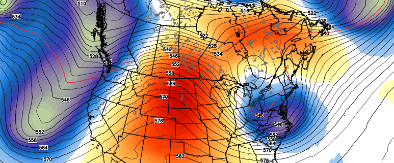
Today has been a rather cold and clear day over the entire Northeast, especially when compared to the past week or so. Stout northwesterly flow has ushered in a much more cold and dry continental Arctic airmass over the entire area, which has kept high temperatures in the upper 20’s to lower 30’s-with some mid 30’s over SNJ and Long Island.

The large, but disorganized mid-level system that we have been going over for the past week has begun to gradually edge into the Northeast this afternoon and has been producing some very light sleet and snow across portions of Pennsylvania and New York. This area of precipitation looks rather impressive on radar, but surface observations confirm that there has been barely any precipitation reaching the surface-even under the heaviest of radar echoes. This is mainly due to the very dry and dense Arctic airmass still in place through the lowest ~500 feet of the atmosphere. As the snow falls towards the ground it is evaporating in addition to transitioning to sleet. Since radar beams gradually increase with height the further out from the radar site you go, these beams are hitting this area of transitioning precipitation, causing the precip to look more intense than whats being observed at the surface.

Regardless, the narrow band of mixed precipitation will continue to gradually head east over the next few hours–likely impacting the metro area just in time for the evening commute. Due to the very unimpressive forcing and low level dry air in place, mainly sleet and freezing rain is expected for the immediate metro area with a few broken flakes mixing in at times. As we head into the NW suburbs and into portions of SNY, there could be more of a snow/sleet mix, with some very light accumulations on colder surfaces.

Regional Radar Mosaic

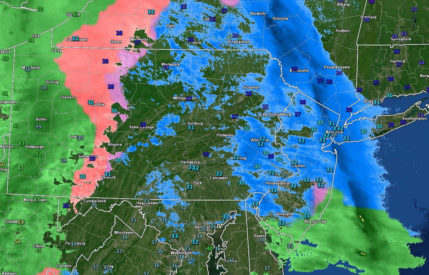
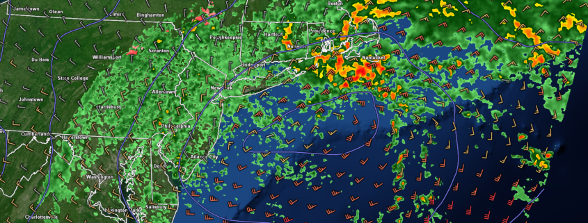
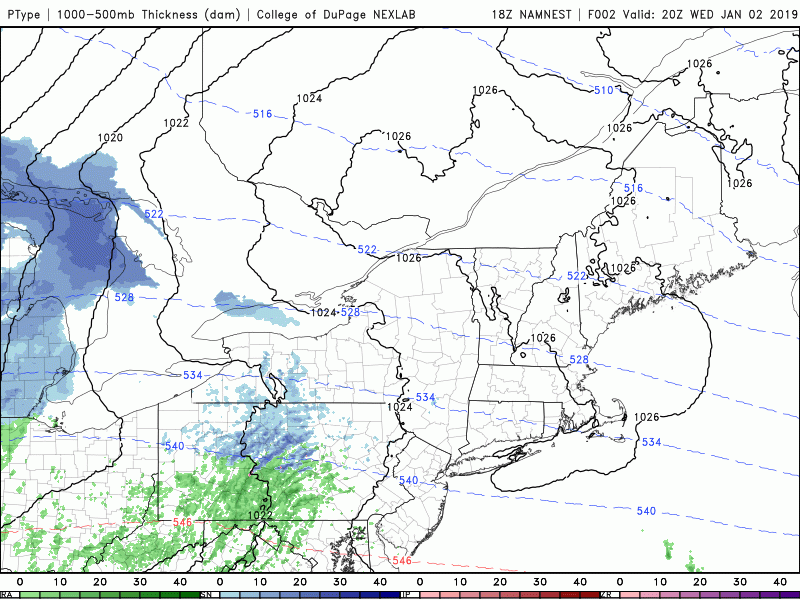
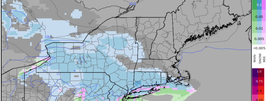
This evenings latest hi-res radar showing an area of light mixed precip working its way into the area 

Light Mix Lingers Into Tuesday Morning

Continue light mixed precipitation mainly in the form of sleet, freezing rain, and rain will be possible as we head into the late evening and overnight hours of Tuesday as the area of high pressure currently situated over New England shifts offshore. This will cause low level winds to become more southerly in nature and will lead to an increase in available moisture. As always, a shift to more southerly winds also means an increase in surface temperatures over the entire area.

Locations over SNJ will be the first to really feel the effects temps rising above freezing, which will cause a changeover to all rain before 5 am. Since this current airmass has been rather stubborn, it may take some time for the warmer air to make its way north of NYC, but the changeover will continue through the overnight hours and into the very early morning hours tomorrow. At this time, locations north and west of the New York City area have the best chance at seeing prolonged periods of light sleet and freezing rain lasting through 5 am. Any accumulations with this system will be quite minimal, with the potential for some slippery roads by the time we reach the AM commute.

Temperatures will then quickly rise to above-freezing for the entire area around 8 am tomorrow morning as the last of the precipitation swings through. Though some dry air is expected to develop aloft as the main upper level system moves through tomorrow afternoon, skies should remain mostly cloudy with a chance at some light rain showers or drizzle lasting into the evening hours. Highs will likely reach into the lower to middle 40’s for the entire forecast area as cloudy conditions and mild low-level temps take over.

Things get a little more interesting towards the overnight hours of Tuesday as strong mid-level energy and residual moisture move through the Northeast with an associated cold front. This will create the potential for some increased precipitation to breakout after midnight. Given the steep changes in temperature with height and weak instability, there may even be some heavy spots of sleet and graupel that develop over portions of Pennsylvania and New Jersey. Otherwise, tomorrow night will be another mild night, with lows only getting down into the upper 30’s to lower 40’s with winds picking up significantly after the cold front moves through.

HRRR Sim Rad

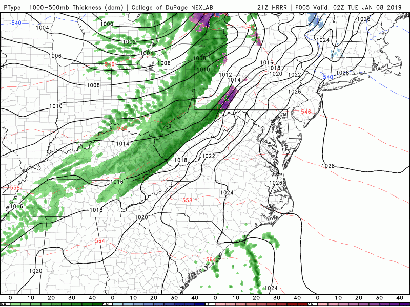
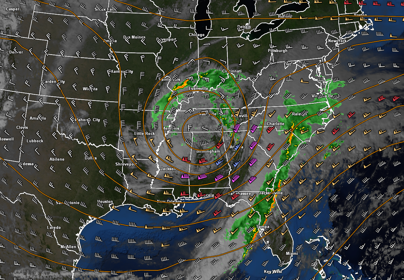
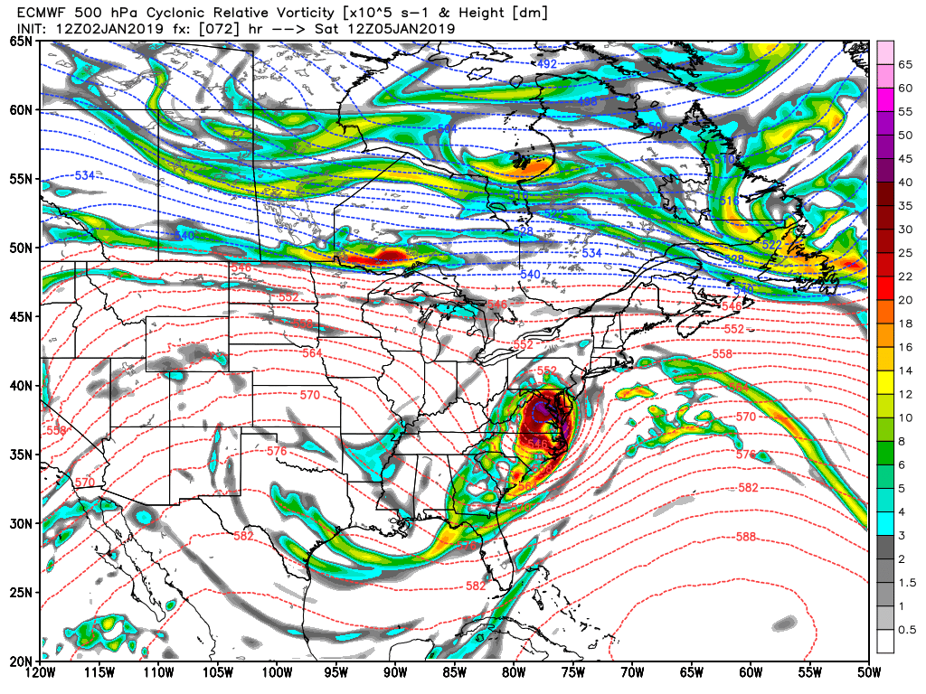
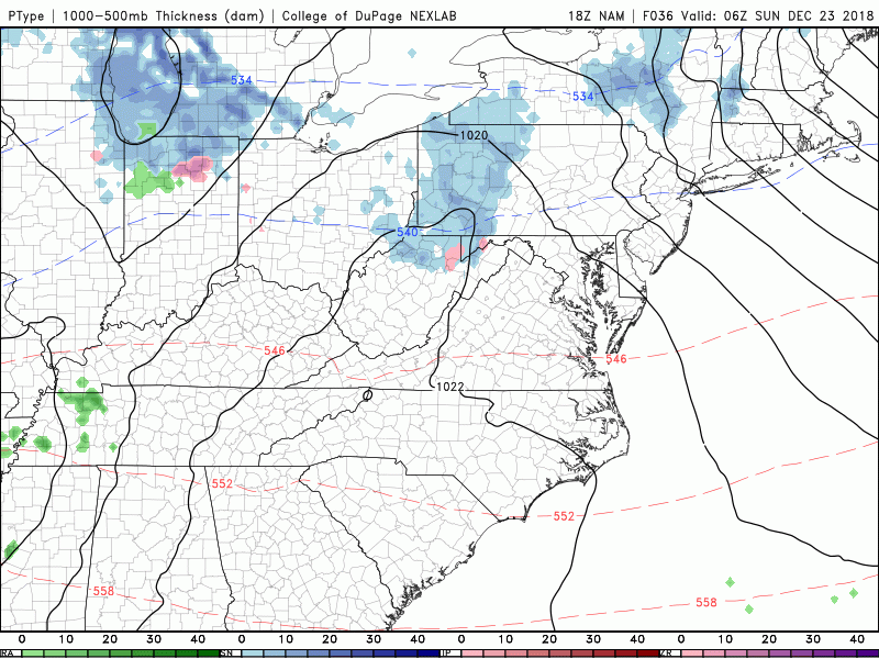
This evenings HRRR model showing the light area of mixed precipitation impacting our area later this evening and into the overnight hours

Attention Turns Towards This Weekend

Mainly calm and cold conditions will remain in place across much of the east for the rest of this week and lasting into this weekend. Northwesterly flow will be in place during this time, leading to below-normal temperatures and mainly dry weather. However, there are signs that we may have to watch a system coming out of the Southern Plains by Friday afternoon. The past few runs of the reliable computer models and their ensembles have shown that this piece of energy may try to interact with an incoming strong piece of energy from Canada. As of right now there are two scenarios being shown with this setup:

The first (and least likely as of now) is that the shortwave trough over the Plains will phase with the incoming Canadian shortwave trough on Saturday. This would cause a large area of heavy snow to develop from the Midwest to the East Coast on Saturday/Sunday with significant impacts.

The second (and most likely as of now) is that the shortwave over the South is not able to cleanly phase/interact with the incoming shortwave over Canada. Instead, the Canadian shortwave acts to suppress this system and the vast majority of the precipitation stays to the south of the NYC area, causing little to no impacts.

It is very important to note that we are still quite a while out, and significant changes are likely to occur between now and Friday. The overall evolution of this system will depend on the exact timing and location of each system and we will have to watch how these systems behave over the next four days.

GFS 500mb

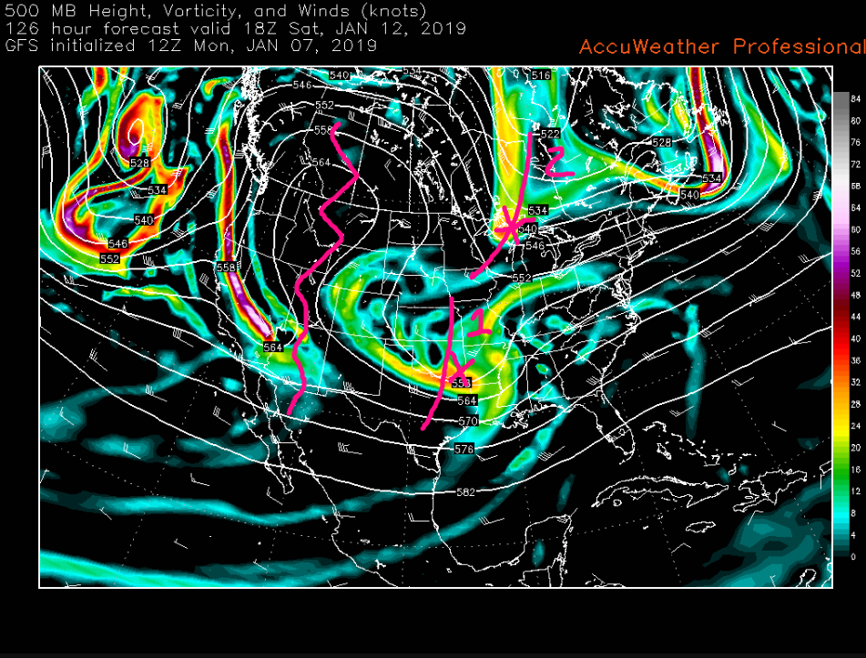
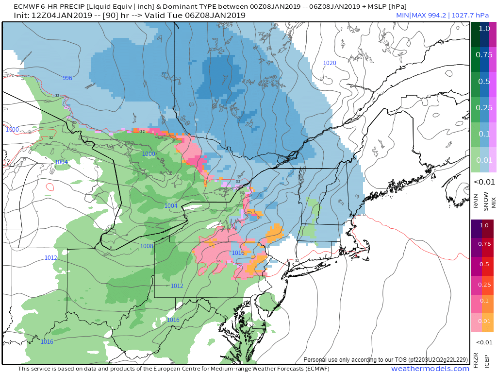
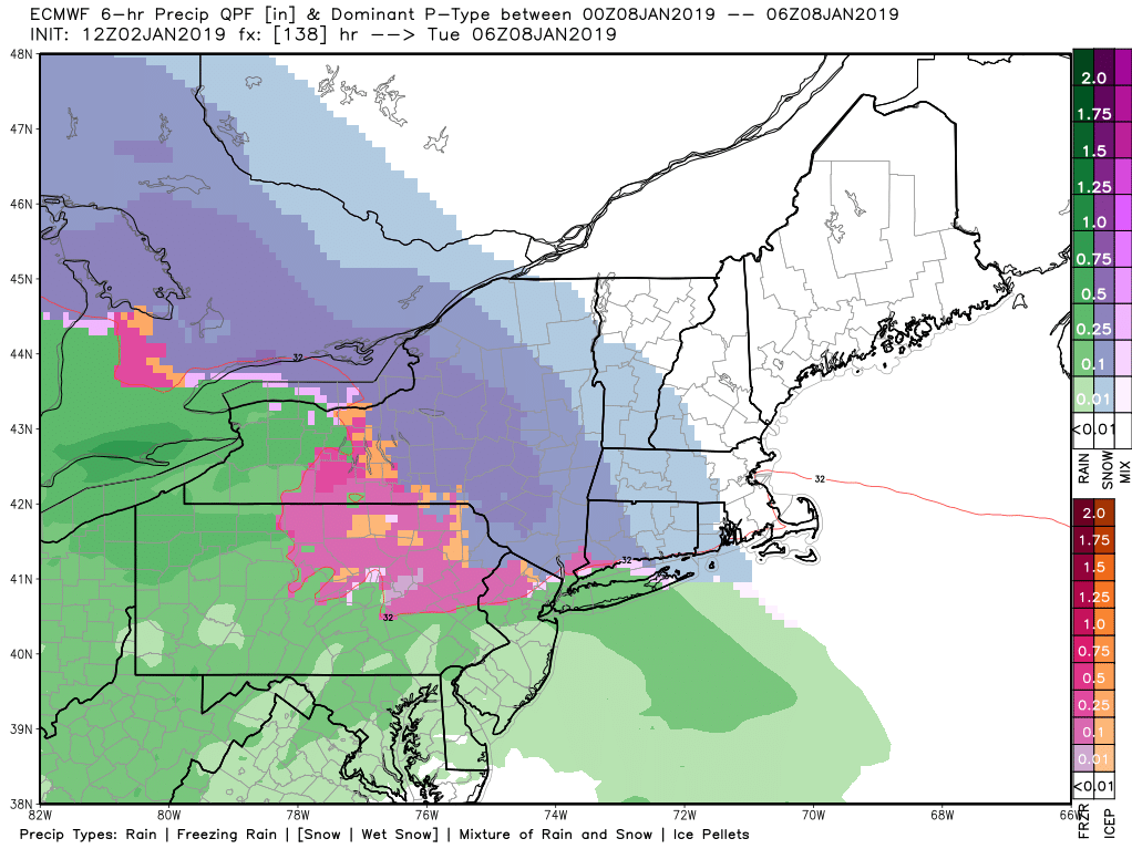
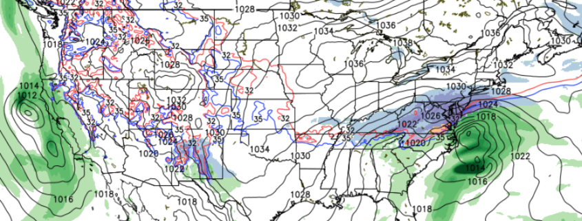
This mornings GFS model which was the most aggressive model at the time. This model was phasing both the feature over the Plains and over Canada to produce a large snowstorm for the Northeast

Thanks for reading and have a great night! We’ll have an update on Wednesday!

-Steve Copertino

Saturday Soaker, Light Mix Monday?

Good evening and Happy Friday! 

Today has been another gloomy and cool Friday across much of the Mid-Atlantic and Northeast as out next system gradually approaches from the south. Increasing mid-level flow from the southwest has lead to a warmer and more moist air working its way into the region, with clouds on a steady increase during the afternoon hours. Despite the increasing cloudiness, temperatures have been able to reach into the middle to upper 40’s across the entire New York metro area. This is anywhere from 10-12 degrees above-normal for early January.

Clouds will continue to thicken during the evening and overnight hours as more moist air begins to stream northward ahead of a large cut-off low over the Southeastern states. It appears that any showers for the metro area should hold off until the early morning hours of Saturday, but southern portions of New Jersey could see some light to moderate rain begin to overspread the area by 11pm-1am. With thickening clouds, a mild mid-level airmass, and an approaching storm system, temperatures will only fall just a bit after sunset. Lows will only be able to reach back down into the middle to upper 30’s before southerly winds begin to cause an increase in temperatures overnight into the upper 30’s and lower 40’s.

GREarth

This evenings regional radar mosaic showing a large upper level low approaching the Mid-Atlantic this evening

Soaker of a Saturday Incoming, Improving Conditions on Sunday 

As the large upper level low located to our south begins to slightly become more organized Friday night and into Saturday, a surface low pressure system will begin to develop near Norfolk, Virginia. As this low begins solidify, a large area of steady rain should begin to overspread the entire New York metro area by 5-7am. The surface low pressure located to our south will help to direct a deep moisture feed directly into the area, likely causing a heavier batch of rain to move through around 8-10 am. While dynamics aren’t too impressive with this system overall, we could still see some localized areas of very heavy rainfalls with even a rumble of thunder mixed in–especially over portions of Long Island.  As we head into the late morning and early afternoon hours on Saturday, the surface low pressure should then track off of the Southern New Jersey coast pushing the vast majority of the remaining heavy rainfall off the Mid-Atlantic coast. Additionally, highs will be once again be stuck in the lower to middle 40’s across much of the area, with upper 40’s possible along the coast.

Due to less-than-impressive dynamics and the potential for some dry air to get involved at the mid-levels of the atmosphere, the remaining precipitation on the western edge of the low should be more “showery” in nature-with drizzle possible as well. While occasional light to moderate rainfall is likely into the afternoon hours, the overall intensity should be greatly reduced when compared to the morning. These dreary conditions should last well into the evening hours, with the chance at some breaks in the precipitation before the main area of low pressure heads off to the north and east. The rain will finally tapper off from west to east Saturday night, with conditions quickly improving as this system pulls away. Expect breezy conditions and temperatures falling back down into the lower to middle 30’s for much of the area.

Sunday will be much more calm, with stout northwesterly flow overspreading the entire Northeast. Breezy and cool conditions are to be expected for much of the day as an area of high pressure begins to push southeastward from Canada. Additionally, high temperatures will also reach back into lower to middle 40’s, with middle to upper 30’s off to the north and west of the city. Calm conditions and clearing skies will last well into the evening and overnight hours as high pressure continues to build into the area. Conditions will be quite ripe for radiational cooling to take place Sunday night, with lows dropping into the lower to middle 20’s for the majority of the metro area, with teens even possible for NW NJ and SNY.

NAM 3k Simulated Radar

This evenings hi-res NAM model showing the evolution of the storm system later this evening and into Saturday night

Light Mix Possible Monday Night, Above-Normal Temps Continue Into Next Week 

A large mid-level ridge will be over much of the East Coast on Monday, leading to cooler temps and relatively calm conditions, however our next system will not be far behind.

Another large, but disorganized area of energy will be over the Northern Plains by Monday afternoon, likely resulting in a sizable amount of mixed precipitation breaking out over the Midwest. Model guidance over the past day or so has become less organized with this upper level system, leading to a weaker surface reflection and much less precipitation overall. As this system likely begins to move through the Ohio Valley on Monday night and into the very early morning hours of Tuesday, the area of high pressure over the Northeast will begin to move offshore. As of right now there is a strong chance that the initial precipitation that moves through the Northeast will come in as a mix of snow, sleet, and freezing rain due to the residual cold air from the departing high pressure system. As we get into the day on Tuesday, all leftover precipitation should change to plain rain as warmer air from the south pushes into our area. At this time, chances of any significant impacts from wintry weather appear quite low.

Most of the reliable computer model guidance have the upper level system responsible for this system lingering over the Northeast through Wednesday, potentially producing another batch of light mixed precipitation over the Northeast, but it is much too early to talk about any specifics at this time.

We’ll continue to update you on both potential system over the coming days!

ECMWF Tuesday 6z

This afternoons ECMWF model showing the potential for some light mixed precip entering the Northeast on Monday night

Have a great weekend!

Steven Copertino

500mb height anomalies 1/9

Light Mix Tonight, Unsettled Pattern Remains In Place

Good evening! 

Well it may be a new year, but we are certainly stuck in the same old pattern that we have been entrenched in since the beginning of December. A decaying high pressure system to our north is currently moving off the coast of New England, which has allowed for a more mild and moist airmass to overspread the Mid-Atlantic and much of the Northeast. Clouds have been on the increase for virtually the entire day, and the combination of increasing clouds and mid-level flow switching over to the southwest has allowed for temperatures to rise into the upper 30’s to lower 40’s this afternoon. While still generally “cool”, these temperatures are anywhere from 5-10 degrees above normal for early January.

Cloudiness will continue to increase throughout the rest of this evening and into the overnight hours as a weak shortwave trough approaches the Northeast from the Great Lakes. Temperatures will be falling tonight, but the increasing cloudiness will put a cap on just how low they can fall tonight. Precipitation from the weak area of low pressure approaching the New York City metro will likely begin as a light snow/rain mix by 11pm-1am, but should quickly turn to all rain for the vast majority of the area. Locations that have the best chance at staying mostly (light) snow through the overnight hours will be elevated locations that are off to the north and west of the immediate New York City area.

Regardless, this system will be moving very quickly to the east this evening/overnight, which will severely limit how much moisture from the south is able to interact with it. Even those who manage to stay 100% frozen tonight will only see a half-inch of snow at best–most of which will be erased as precip quickly shuts off from west to east before dawn.

This evenings high-resolution NAM model showing the evolution of the quick-hitting system this evening/overnight

Yet Another Rainstorm Likely on Saturday 

As mentioned, the area of low pressure impacting our area through the overnight hours and into the early morning hours of Thursday will be quickly moving off the coast by the AM commute. As this system departs, any remaining precipitation over the Northeast will come to an end by the early afternoon hours. Partly cloudy skies with breezy conditions will be prevalent tomorrow afternoon, with temperatures remaining in the middle to upper 40’s. Our next system will remain off to the south long enough to allow for calm conditions to persist through the evening and overnight hours tomorrow night. Clear skies and gradually subsiding winds will allow for radiational cooling to set up, which will cause temperatures to drop into the middle to upper 20’s across the entire forecast area.

Conditions will remain calm and clear into Friday as surface high pressure quickly moves to our south during the day. This will cause dry and mild weather for the majority of the day, with temperatures once again staying in or around the middle 40’s. The weak surface high pressure will then quickly exit off the coast by Friday afternoon, which should set the stage for a cut-off upper level low to gradually move into the Mid-Atlantic states on Friday evening. Cloudiness will slowly increase from north to south Friday night, with showers developing over portions of Southern New Jersey by 8-10pm. This slow-moving system will not have any cold air to work with as precipitation moves to the north, so this entire storm will be another wet and mild system.

As the upper-level low continues to edge in over the Mid-Atlantic during the early morning hours on Saturday, surface low pressure will begin to intensify off to our south. This will result in another impressive low-level jet overspreading the NYC metro area, with more steady rain developing by the late morning/afternoon hours on Saturday. The surface low should then take on a more easterly course during the day, likely moving off the NJ coast during the afternoon hours. Steady rainfall will continue into the evening, before gradually tapering off from west to east Saturday night. Though the exact amounts and timing will still need to be tweaked over the coming days, this looks to be another dreary and inconvenient weekend storm opposed to anything truly impactful-outside the potential for some coastal flooding.

ECMWF 500mb vort

This afternoons ECMWF model showing a compact closed low over the Mid-Atlantic on Saturday morning

Unsettled Conditions Last Through Next Week

An active northern stream jet will allow for another disorganized shortwave to move through the Northern Plains states on Monday and into the Great Lakes by Monday night. While there may be some blocking over Greenland at this time to allow the system to slow down a bit and organize before impacting our area, there is still no real cold air source anywhere outside of New England and Southern Canada. This afternoons model runs have been rather consistent in showing the possibility of some front-end mixed precipitation for our area overnight Monday, before a changeover to rain Tuesday morning as the surface low tracks over the Lower Hudson Valley.

At this time the overall potential for impactful winter weather looks to be low for the NYC area, with an increasing chance once you get into New England. It is important to note that this system is still five to six days out and there are many details that need to be ironed out. We will continue to update you over the next couple of days on this potential system!

ECMWF model

PM European model showing the potential for some wintry weather over portions of the Northeast Monday night/Tuesday

Have a great night! 

Steve Copertino

Cold front arrives Saturday, watching two light snow events around Christmas

Improving conditions Saturday, watching a system to our west on Sunday night

After the passage of a cold front this morning, temperatures are falling and wind gusts are picking up. Clouds will also be diminishing throughout the day as well, allowing for mostly clear skies to overtake the region by the mid/late afternoon hours. The combination of these factors will mean that today will be much cooler than the previous couple of days, but not quite “cold”. After the passage of the cold front, most of the area should see temperatures drop into the middle to upper 30’s, with some 40 degree readings possible along the coast. Conditions will remain calm and clear for the remainder of the day, with any residual gusty winds dying down tomorrow evening. This should allow for temperatures to drop back into the upper 20’s and lower 30’s tomorrow night, which is right around normal for this time of year.

Sunday should start off as an excellent day, with sunny skies and temperatures in the lower to middle 40’s across the entire forecast area. However, we will have to watch a shortwave trough off to our west that will be moving through the Ohio Valley by Sunday evening. Model guidance diverges significantly on the exact evolution of this system, but there is a low chance that this system is able to cause an area of light rain/snow to develop over portions of the Mid-Atlantic and Northeast late Sunday and into the very early morning hours on Monday. This system will be moving very quickly from west to east, will not have a lot of moisture associated with it, and the airmass it will be moving into will be quite marginal for snow. It appears that any potential for anything outside of a brief coating of snow is quite low, and this system should not cause significant travel issues overnight Sunday and into the very early morning hours of Monday before moving off the coast by daybreak Monday.

NAM Simulated Radar

This afternoons NAM model showing an outside chance for a potential light rain/snow event Sunday night/Monday morning

Another weak system passes through Wednesday, conditions go downhill once again late next week 

Conditions should be quite pleasant for much of the area on Tuesday (Christmas Day), with mostly sunny conditions and highs in the upper 30’s to lower 40’s expected. Calm and cool conditions should last throughout the entire day, with lows eventually dropping down into the middle to upper 20’s-with coastal locations likely in the lower 30’s. By the time we head into the overnight hours, our attention turns to the Ohio Valley once again. Yet another moisture-starved northern stream shortwave trough will be quickly moving from west to east, possibly causing an area of very light rain and snow showers to develop from west to east Christmas night and into the very early morning hours of Wednesday. Once again, due to the quick-moving nature of this system and the marginal airmass in place, any accumulation potential will be very low for the New York metro area.

A large area of high pressure will begin to build over much of the east on Wednesday as the next major storm system begins to build over the Plains states. This system looks to take a track predominately up over the middle of the country, which should once again drag a warm/moist airmass from the south and up into the Northeast. Though this system is still a week out, there appears to be a heightened threat of yet another dreary and wet end to the week next week across much of the eastern half of the country.

ECMWF 850mb Winds/Temps

This afternoons ECMWF model showing another exspansive storm system moving off to our west, bringing unsettled and above-average conditions to much of the East

We’ll have an update on the potential light snow events and any other threats that may arise by the later half of this weekend! 

Have a great Holiday Weekend! 


Steve Copertino