-2")
Overview
Briefing
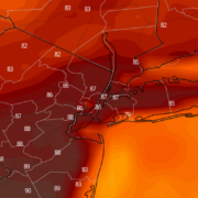
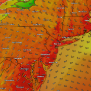
Hot and humid conditions will continue through Tuesday. Chances for showers and t-storms will increase as a cold front approaches on Wednesday. More comfortable warmth and humidity is expected late week.
Forecaster’s Discussion
Last Updated: 9:30am Thursday, July 26th 2019 by MP
Near Term (through tonight)
High pressure will provide mostly sunny skies today. 850mb temperatures around 12-13 C with deep mixing and light northwest downslope winds will support high temperatures closer to normal-in the middle 80s throughout much of the region. Humidity will still be relatively low, which will make for another beautiful mid-summer day.
Tonight, will remain mostly clear with light winds. This will result in more radiation cooling. Low temperatures are likely to in the mid 60s many of suburbs and in upper 60s to near 70 degrees in NYC and urban areas. Some of the far northern Interior valleys will likely drop into the upper 50s to lower 60s.
Hello
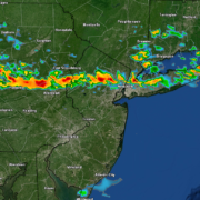
Severe thunderstorms possible Saturday afternoon!
Good evening and happy Friday! Hot, but mostly calm conditions remain in place across much of the Northeast today. Things may “spark up” a bit tomorrow afternoon with the development of strong to potentially severe thunderstorms.
Warmth, humidity and unsettled weather expected this week
Beautiful weather from this weekend has carried over in to Monday – finally! High clouds are moving in to the region this afternoon, marking the start of a changing pattern. Light winds have allowed for the development of some seabreezes along the area shores. Otherwise, the weather remains calm and benign. The pattern will kick […]
Sunny skies and calm conditions throughout the weekend!
Good afternoon and happy Friday! After what seems like weeks of being stuck in the same pattern, a break is on the way! This weekend will be a massive improvement over the past few days, with mostly sunny skies and dry weather.