-2")
Overview
Briefing
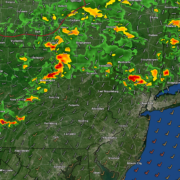
Hot and humid conditions will continue through Tuesday. Chances for showers and t-storms will increase as a cold front approaches on Wednesday. More comfortable warmth and humidity is expected late week.
Forecaster’s Discussion
Last Updated: 9:30am Thursday, July 26th 2019 by MP
Near Term (through tonight)
High pressure will provide mostly sunny skies today. 850mb temperatures around 12-13 C with deep mixing and light northwest downslope winds will support high temperatures closer to normal-in the middle 80s throughout much of the region. Humidity will still be relatively low, which will make for another beautiful mid-summer day.
Tonight, will remain mostly clear with light winds. This will result in more radiation cooling. Low temperatures are likely to in the mid 60s many of suburbs and in upper 60s to near 70 degrees in NYC and urban areas. Some of the far northern Interior valleys will likely drop into the upper 50s to lower 60s.
Hello
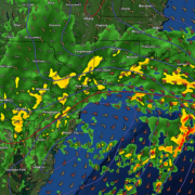
Warm temps return, chance of storms through Monday
Good evening and happy Friday! Thankfully, conditions have improved quite dramatically today over the entire NYC metro area! Relatively calm conditions are likely through the first half of the weekend before conditions turn muggy & potentially stormy by Sunday!
PM Update: Clearing late tonight, warm and active pattern ahead
After a raw and rainy morning, the sun has made a cameo appearance this afternoon! It’s a welcomed sight, with temperatures spiking up into the upper 60’s (still well below normal for this time of year, by the way). Another round of showers and thunderstorms is possible with a secondary disturbance this afternoon and early […]
Low pressure to bring cool and rainy conditions Thursday
Good evening! We have a bit of good news and bad news for you. First, the bad news is that after two banner days, rainy and cooler conditions will affect the entire area tomorrow. The good news is that this system should be out of our hair by Friday, with much warmer conditions in store […]