-2")
Overview
Briefing
Hot and humid conditions will continue through Tuesday. Chances for showers and t-storms will increase as a cold front approaches on Wednesday. More comfortable warmth and humidity is expected late week.
Forecaster’s Discussion
Last Updated: 9:30am Thursday, July 26th 2019 by MP
Near Term (through tonight)
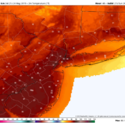
High pressure will provide mostly sunny skies today. 850mb temperatures around 12-13 C with deep mixing and light northwest downslope winds will support high temperatures closer to normal-in the middle 80s throughout much of the region. Humidity will still be relatively low, which will make for another beautiful mid-summer day.
Tonight, will remain mostly clear with light winds. This will result in more radiation cooling. Low temperatures are likely to in the mid 60s many of suburbs and in upper 60s to near 70 degrees in NYC and urban areas. Some of the far northern Interior valleys will likely drop into the upper 50s to lower 60s.
Hello
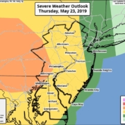
Additional showers and thunderstorms expected Thursday
To the shock of absolutely nobody, showers and thunderstorms are again anticipated today. This will be the third straight day with a risk of severe weather in the Northern Mid Atlantic states. While the risk for widespread severe thunderstorms will be a bit lower than it was on Tuesday and Wednesday, a threat for heavy […]
Warm and pleasant Memorial Day weekend ahead!
Good evening and happy Friday!
Strong thunderstorms possible Thursday afternoon
Good evening! Today has been another excellent across the entire area! While the mild/seasonable temperatures look to stay, we may have to deal with some strong thunderstorms on Thursday!