-2")
Overview
Briefing
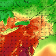
Hot and humid conditions will continue through Tuesday. Chances for showers and t-storms will increase as a cold front approaches on Wednesday. More comfortable warmth and humidity is expected late week.
Forecaster’s Discussion
Last Updated: 9:30am Thursday, July 26th 2019 by MP
Near Term (through tonight)
High pressure will provide mostly sunny skies today. 850mb temperatures around 12-13 C with deep mixing and light northwest downslope winds will support high temperatures closer to normal-in the middle 80s throughout much of the region. Humidity will still be relatively low, which will make for another beautiful mid-summer day.
Tonight, will remain mostly clear with light winds. This will result in more radiation cooling. Low temperatures are likely to in the mid 60s many of suburbs and in upper 60s to near 70 degrees in NYC and urban areas. Some of the far northern Interior valleys will likely drop into the upper 50s to lower 60s.
Hello
Beautiful warm weather overall this weekend, scattered storms possible late Sunday and Monday
Happy Saturday! High pressure will continue to provide partly to mostly sunny skies today. Temperatures will be a little cooler than on Friday. But it will still be warm this afternoon with highs reaching the lower to middle 70s throughout much of the New Jersey and New York City area. Winds will be mostly light […]
Volatile conditions last throughout Mother’s Day weekend
Good evening and happy Friday! Unfortunately, the fickle weather conditions that have plagued our area look to continue through Mothers Day weekend. While Saturday may start off decent, more wet and unseasonably cool conditions are on the horizon!
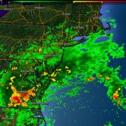
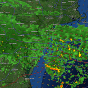
Shower threat continues for majority of the weekend
Good evening and happy Friday! Unfortunately, this weekend is setting up to be a rather dull and dreary one for the entire area. A series of disturbances will be moving through the area bringing the threat of rain for most of the weekend.