-2")
Overview
Briefing
Hot and humid conditions will continue through Tuesday. Chances for showers and t-storms will increase as a cold front approaches on Wednesday. More comfortable warmth and humidity is expected late week.
Forecaster’s Discussion
Last Updated: 9:30am Thursday, July 26th 2019 by MP
Near Term (through tonight)
High pressure will provide mostly sunny skies today. 850mb temperatures around 12-13 C with deep mixing and light northwest downslope winds will support high temperatures closer to normal-in the middle 80s throughout much of the region. Humidity will still be relatively low, which will make for another beautiful mid-summer day.
Tonight, will remain mostly clear with light winds. This will result in more radiation cooling. Low temperatures are likely to in the mid 60s many of suburbs and in upper 60s to near 70 degrees in NYC and urban areas. Some of the far northern Interior valleys will likely drop into the upper 50s to lower 60s.
Hello
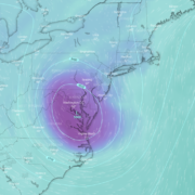
Heavy rain possible tonight, upper level low lingers
Good evening and happy Friday! A large upper level low that is currently over the Southeast US looks to plague our sensible weather with multiple chances of rain throughout the holiday weekend!
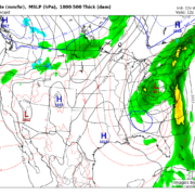
Conditions turn unsettled with heavy rain likely Friday night
Good evening! The brief period of tranquil weather that has been present over the past two days looks to be coming to an end. A large upper level system will move into the Northeast by Friday, creating the potential for periods of heavy rain.
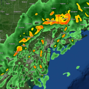
Showers continue tonight, unsettled weekend ahead
Good evening and happy Friday! Multiple periods of rain are likely over the next few days as a series of storm systems move across the country.