-2")
Overview
Briefing
Hot and humid conditions will continue through Tuesday. Chances for showers and t-storms will increase as a cold front approaches on Wednesday. More comfortable warmth and humidity is expected late week.
Forecaster’s Discussion
Last Updated: 9:30am Thursday, July 26th 2019 by MP
Near Term (through tonight)
High pressure will provide mostly sunny skies today. 850mb temperatures around 12-13 C with deep mixing and light northwest downslope winds will support high temperatures closer to normal-in the middle 80s throughout much of the region. Humidity will still be relatively low, which will make for another beautiful mid-summer day.
Tonight, will remain mostly clear with light winds. This will result in more radiation cooling. Low temperatures are likely to in the mid 60s many of suburbs and in upper 60s to near 70 degrees in NYC and urban areas. Some of the far northern Interior valleys will likely drop into the upper 50s to lower 60s.
Hello

Wild temperature fluctuations into the weekend
Good evening! A complex forecast is setting up for the area as a backdoor cold front looks to plague our high temperatures!
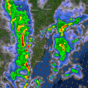
Heavy rain and thunderstorms likely tonight
Good afternoon and happy Friday! Widespread showers and thunderstorms have developed across much of the Mid-Atlantic and Northeastern states this afternoon. Heavy rain, gusty winds, and frequent lightning will all be possible later this evening/tonight for much of the NYC area!
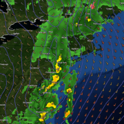
High pressure exits, next storm system not far behind
Good afternoon! A weak area of high pressure has built into the region today, allowing for sunny skies and warm temperatures. However, these conditions will not last long as another system approaches tomorrow.