-2")
Overview
Briefing
Hot and humid conditions will continue through Tuesday. Chances for showers and t-storms will increase as a cold front approaches on Wednesday. More comfortable warmth and humidity is expected late week.
Forecaster’s Discussion
Last Updated: 9:30am Thursday, July 26th 2019 by MP
Near Term (through tonight)
High pressure will provide mostly sunny skies today. 850mb temperatures around 12-13 C with deep mixing and light northwest downslope winds will support high temperatures closer to normal-in the middle 80s throughout much of the region. Humidity will still be relatively low, which will make for another beautiful mid-summer day.
Tonight, will remain mostly clear with light winds. This will result in more radiation cooling. Low temperatures are likely to in the mid 60s many of suburbs and in upper 60s to near 70 degrees in NYC and urban areas. Some of the far northern Interior valleys will likely drop into the upper 50s to lower 60s.
Hello
Quiet end to the week, watching a few weak systems next week
Good evening! Today has been a somewhat unsettled day, but a large improvement overall compared to yesterday when much of the area was battling snow and ice.
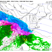
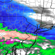
Snow and sleet to cause travel concerns Tuesday
Good evening! Today has been a rather dull and cold day across much of our area as an upper level disturbance off to our west continues to produce widespread overcast. Some light to moderate areas of snow have been reported over southern portions of New Jersey today. The main story for our area continues to […]
Snow, sleet and rain all expected to start the week
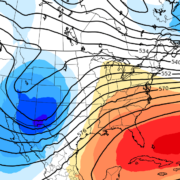
A prolonged period of benign weather, which has largely dominated the past few weeks, will come to a sudden end this week. Multiple rounds of wintry weather are expected, beginning Sunday Night and continuing through Tuesday Night. The most impactful weather will come on Tuesday morning. The story begins with a weak disturbance, which is […]