-2")
Cool and dry weekend, snowstorm threat looms
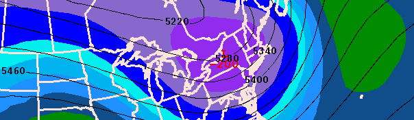
Canadian model (CMC) showing a significant snowstorm impacting the area on Monday. The CMC remains one of the farther north models within the envelope of guidance.
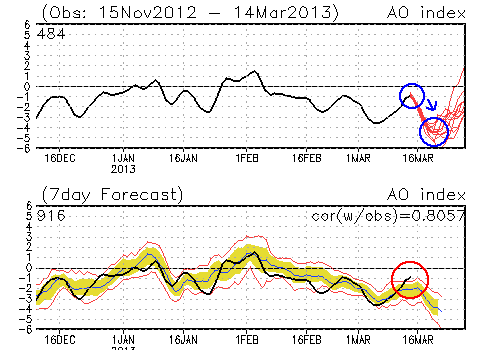
Not only is March madness taking place in the college basketball world, but it’s also taking place in our world of meteorology. Cooler than normal air remains well settled into the region to begin the weekend, as historically strong blocking near Greenland and the North Pole as well as a historically negative Arctic Oscillation (AO) has led to a late-March pattern that feels more like mid-February. High temperatures in the 40’s and cold westerly winds have been a staple in the area weather the past few days. Much of the same is expected through the first half of the weekend, with cooler and dry conditions prevailing. Attention will then turn to a potential snowstorm (yes, snowstorm) on Monday. Forecast models are struggling with the track and intensity of the system as well as the resulting impacts on our area. We’ve detailed the entire threat below.
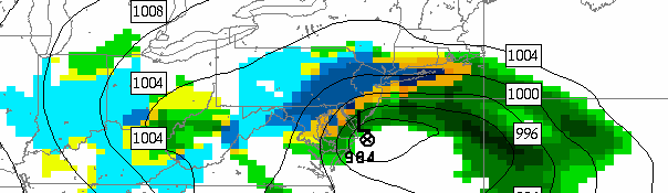
SREF ensemble mean showing a significant snowstorm on Monday.
It’s Spring. What is causing the threat for the snowstorm? Historically strong blocking over the high latitudes (extending from Greenland to the Pole) is displacing unseasonably cold air into the Northern 1/3 of the US. At the same time, a strong disturbance is ejecting out of the Pacific Northwest into the Central United States. Such a storm track could occasionally cause a rain storm in our area, especially this time of year, with the surface low tracking to our west. However, the presence of the unusually strong blocking is forcing the system farther south, to redevelop off the East Coast. The presence of cold air to the north and throughout our area is increasing the likelihood of snowfall if precipitation makes it to our area.
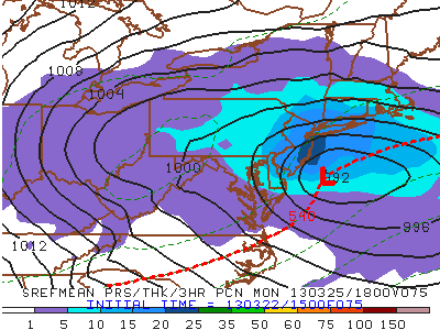
What are the uncertainties with the system? One reason why blocking patterns can be so unseasonably cold is the fact that they force powerful Upper Level Low (ULL) pressure systems to meander at latitudes just to our north and northeast, which are a great source of cold air. However, when an ULL is too powerful and too close to our area, it can compress the height field out ahead of our storm and force it drift eastward instead of turning the corner and heading up the coastline. We do know that eventually, the storm will run into a brick wall and be forced to drift eastward. However, will it do this after it gets to only Ocean City Maryland’s latitude, south Central Jersey’s, or somewhere in between? This is the difference between a graze, a moderate rain to snow event, and a major snowstorm.