Posts

October blocking could hint at winter pattern

Autumn began just a few days ago, but the weather pattern has already adjusted to the fall-like pattern with temperatures falling into the 30’s and 40’s at night. The first cold nights of the year typically come in mid to late September, as the warm and humid days of summer fade. The cooler, more crisp air gives us the first small taste of the cold winter which is only a handful of weeks away. The pattern has begun its seasonal change, and we are beginning to feel the effects of it. Yet, the best hints of what the winter pattern may have in store for us may be hundreds and thousands of miles to our north — over the high latitude/arctic region.

Seasonal forecasting can be a tedious and intricate task for meteorologists. Many times, meteorologists and forecasters alike find themselves drawing upon past events, analogs, and other research for help with predicting the months ahead. This is especially true in the Autumn season, as winter forecasting begins. Meteorologists are about to enter a flurry of forecasting over the next few months (yes, we are somehow enjoying this benign and calm weather right now). So as we look forward to the winter, we can often use the preceding months as indicators of the pattern to come. The pattern itself can often tip its hand, giving us a clue as to what we may be dealing with a few months down the road.

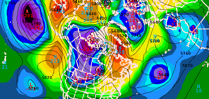
The words “high latitude blocking” likely will instantly bring back memories of some of our stronger storms and more volatile weather patterns in recent memory. The Blizzard of 2010, Hurricane Sandy, the Nor’Easter just a few weeks afterward. They all occurred during episodes of high latitude blocking, with a negative NAO cor North Atlantic Oscillation (for a background and more information on the NAO, click here). Still, high latitude blocking episodes which occur months before these events can often serve as accurate predictors, foreshadowing in a sense, of the upcoming pattern a few months after. A few months ago, we published some research on the blocking pattern during the month of May helping to predict the pattern during the summer months.

For a bit of reference, high latitude blocking refers to blocking ridges which occur in the higher latitudes over Canada and the North Atlantic (background on atmospheric blocking can be found here). These ridges slow down the jet stream/weather pattern. The high latitude blocking over Greenland, the North Atlantic, or Canada during the winter months often leads to the displacement of very cold arctic air over the United States, very often the Northeast US. The more amplified/slower pattern also leads to the potential for large coastal storm systems and has historically featured snowier and colder periods in the Northeast US.

Read more

Blocking sends disturbance south from Greenland

High latitude blocking, which we discussed earlier this week as an important predictor in summer temperature patterns around our area, is at it again. A large and anomalous blocking ridge, building north from Canada towards the higher latitudes into Newfoundland and Southeastern Greenland, is forcing a disturbance and upper level low to shift southward. The disturbance will track southward today — and can be seen on water vapor and visible satellite imagery early this afternoon. The feature won’t directly impact our area, nor will it cause any widespread unsettled weather on the east coast, but it could reinforce east/southeasterly winds as it passes later this week.

The track of the disturbance is the most unusual. To see an upper level low or disturbance track southward from Greenland all the way to a point just a few hundred miles off of the US East Coast is exceedingly rare. However, one glance at the blocking pattern aloft tells you the story — the disturbance had nowhere else to go, being forced into a small window between the trough over the Atlantic and the blocking ridge to the west over Canada. (Click read more for more imagery).

Read more

Does blocking in May hint at summer weather?

Seasonal forecasting is one of the more tedious and intricate tasks for meteorologists. Not only is it difficult to predict by nature (no pun intended) — but forecast model accuracy skill is greatly reduced at that range. Often, meteorologists find themselves looking back towards past events, and analogs, for help with predicting the months ahead. In our case, interest was piqued when we noted what seemed to be higher than normal frequency of high latitude blocking this year. Hurricane Sandy, the nor’easter which immediately followed, and many events this winter featured patterns that were driven by blocking patterns over Canada, Greenland, and the higher latitudes towards the pole. The blocking pattern was not overly anomalous at least on a per-year basis, but it certainly seemed to be more frequent than the calendar year which preceded it.

As we look forward to May, forecast models are in agreement on the continuation of higher than normal height anomalies at 500mb over Central and Eastern Canada as well as farther north towards Greenland. The continuation of blocking in the higher latitudes, relative to our location, can offer some interesting insights into the summer temperature forecast as we move forward. Is there a common theme amongst the historically warm and historically cool summers in the NYC Area — and can we relate it to Springtime blocking patterns? The answer, may surprisingly to some, is yes.  For the sake of example, take the summer of 2009 and the summer of 2010. Both of these years featured wildly different patterns, with 2009 remaining very cool throughout the summer while 2010 was warm. In 2009, there was very little blocking observed from March through May. 2010, on the other hand, featured periodic blocking in the high latitudes from February through May. Interested yet?

Read more

Blocking episode may create forecast headache

Blocking, both over Eastern Canada and in the high latitudes, more often than not means a forecast headache for our forecast area. We’ve seen it on many occasions with winter storms — as the strong blocking highs create anomalous weather patterns. We saw it with Hurricane Sandy, and the Nor’Easter that followed. And it seems that we may see it again, as we head towards the first week of May.

Forecast models are coming into agreement on the potential for an anomalous blocking pattern to develop over Eastern Canada and the Northwest Atlantic towards Newfoundland. With a shortwave trough predicted to be over Central Canada at that time, the trough may be forced underneath the block into the Ohio Valley and the Mid-Atlantic/East Coast. This would create the opportunity for a “cutoff low” and possibly even a coastal storm — with widespread below normal temperature anomalies wherever the cutoff low and upper level trough tracks.

At this range, the question becomes: How strong will the blocking be, and where will it develop? The positioning of the block, as well as its strength, will have a great deal of impact in determining where the cutoff low will eventually track. This will, in turn, have major impacts on the sensible weather forecast for our area. Needless to say, the potential is there for a prolonged period of showers and unsettled weather — as well as a coastal storm — if the cutoff tracks near our area. If it remains farther south, we may be spared the worst effects.

Forecast models are still struggling with the positioning of the block and positioning of the cutoff low. The Euro (or ECMWF), for example, has the cutoff low staying well to our south while the GFS and Canadian models bring it closer to our area with a prolonged period of rain in the Mid-Atlantic states.

In situations like this one, forecasters can utilize ensembles to see the variance amongst forecast models. In this case, we can check out the GFS Ensembles — which show the average height anomalies at 500mb (mid levels of the atmoshpere) on the left, and the “spaghetti” plot of each ensemble on the right. It is easy to see that most ensembles agree on the strong block developing over Newfoundland and Eastern Canada, but the exact positioning of the upper level trough over the Central US is less certain.

Forecasters will certainly be monitoring the models over the next several days, so be sure to stay tuned for updates on the potential unsettled pattern as we head towards next week. For now, enjoy the pleasant weather through the weekend!