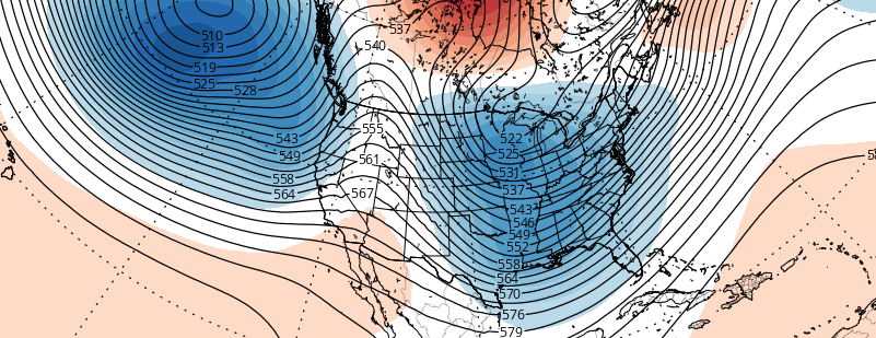
In our previous article, we discussed some of the features in the upcoming hemispheric pattern that could support a winter weather event. These features were particularly evident during the period from January 16th to 20th. As we have gotten closer to this time period, forecast models have come into much better agreement on exactly how these features will evolve.
Winter has finally arrived. Despite potentially record breaking warmth for one day this weekend (Sunday), and the return of rain this weekend as well, we will continue to transition into a colder pattern with an arctic frontal passage on Monday. The atmospheric global circulation pattern is trending much more favorably for winter weather lovers — with teleconnections favoring cold being dislodged into the Northern 1/3 of the United States. With high latitude blocking also in the forecast on all medium range models — the question now becomes: What about the snow?
https://www.nymetroweather.com/wp-content/uploads/2016/01/headernew.png303820Miguel Pierrehttps://www.nymetroweather.com/wp-content/uploads/2024/02/Empire-2000-x-300-px-2.pngMiguel Pierre2016-01-07 20:27:552016-01-07 21:56:37Colder air is on the way, but how about the snow?
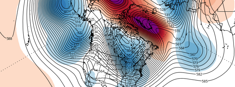
In our winter forecast, we discussed certain signals that supported high-latitude blocking developing for the middle and late periods of this upcoming winter. High-latitude blocking often comes with negative phases of the North Atlantic Oscillation (NAO), the Artic Oscillation (AO), and/or the Eastern Pacific Oscillation (EPO). High-latitude blocking is one most important factors in any winter forecast, as it typically supports colder temperatures and larger snowstorms for the Northeast US. This is an even more important factor in during a strong El Nino winter, as the Pacific or Subtropical jet is generally more active and stronger.
Research from Al Marinaro (@wxmidwest ) brought to light a strong correlation between the sea-level pressures in North Pacific and the NAO modality, during +ENSO (El Nino) winters. North Pacific sea-level pressures less than 1013 mb had a -NAO value on average for the December, January, February, and March period (DJFM). Sea-level pressures above 1013 mb during the month of October had either a positive NAO value or very close to netrual in the following winter. An official pressure for North Pacific reading has not been released for October yet. However, NCEP/NCAR reanalysis tells us that sea-level pressures were on average around 1010 mb over the region 65N-30 & 160E-140W in the North Pacific. That would be well-below the 1013mb threshold for a -NAO DJFM.
https://www.nymetroweather.com/wp-content/uploads/2015/11/highlattop.png280889Miguel Pierrehttps://www.nymetroweather.com/wp-content/uploads/2024/02/Empire-2000-x-300-px-2.pngMiguel Pierre2015-11-08 15:31:472015-11-08 21:10:43The Importance of High Latitude Blocking in The Upcoming Winter
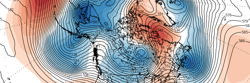
It has been a while since the meteorological community has had the chance to analyze the potential for higher latitude blocking. It has also been a while since we’ve had the opportunity to analyze a synoptic heavy rain event. Both of those look to come to fruition, in multiple facets, over the next five to seven days. A dramatic pattern change will unfold across North America this week, with anomalously strong ridging and surface high pressure building into Canada and the Northwestern Atlantic Ocean. Precariously timed with the formation of a tropical cyclone, this blocking high pressure will lead to a forecasting headache — and the potential for heavy rains and impacts from a Tropical Storm along the East Coast.
For those without a technical background, high latitude blocking is a broad term for higher then normal pressures/heights in the higher latitudes. These “blocking” ridges of high pressure to our north, sometimes over Canada and the Atlantic and sometimes as far north as parts of Greenland, slow down the weather pattern closer to our area. The slower weather pattern can allow disturbances to interact and phase — forming much larger, more powerful storms that otherwise would have continued on their own way if the pattern was moving at a normal progressive speed.
This week, forecast models are in agreement that higher latitude blocking will develop over much of Canada into the Northern Atlantic Ocean. Ridging builds into these areas in the mid levels of the atmosphere, and a very strong surface high pressure builds east and southeast into Canada and even parts of New England. This is one important piece to the forecast headache, and one reason why meteorologists are slightly more concerned than normal at this range: The tropical system, or storm system that forms, cannot simply escape north or northeast. The blocking will slow down the pattern considerably.
https://www.nymetroweather.com/wp-content/uploads/2015/09/Capture.png216662John Homenukhttps://www.nymetroweather.com/wp-content/uploads/2024/02/Empire-2000-x-300-px-2.pngJohn Homenuk2015-09-28 20:36:102015-09-28 20:36:10Tropical system, blocking will lead to forecasting headache
Hi friends! Our website uses cookies to provide an optimal browsing experience for you. New "Cookie Consent" laws mandate us to inform you of this. As long as you're cool with it, just hit OK. You'll only see this message once.
We may request cookies to be set on your device. We use cookies to let us know when you visit our websites, how you interact with us, to enrich your user experience, and to customize your relationship with our website.
Click on the different category headings to find out more. You can also change some of your preferences. Note that blocking some types of cookies may impact your experience on our websites and the services we are able to offer.
Essential Website Cookies
These cookies are strictly necessary to provide you with services available through our website and to use some of its features.
Because these cookies are strictly necessary to deliver the website, refusing them will have impact how our site functions. You always can block or delete cookies by changing your browser settings and force blocking all cookies on this website. But this will always prompt you to accept/refuse cookies when revisiting our site.
We fully respect if you want to refuse cookies but to avoid asking you again and again kindly allow us to store a cookie for that. You are free to opt out any time or opt in for other cookies to get a better experience. If you refuse cookies we will remove all set cookies in our domain.
We provide you with a list of stored cookies on your computer in our domain so you can check what we stored. Due to security reasons we are not able to show or modify cookies from other domains. You can check these in your browser security settings.
Other external services
We also use different external services like Google Webfonts, Google Maps, and external Video providers. Since these providers may collect personal data like your IP address we allow you to block them here. Please be aware that this might heavily reduce the functionality and appearance of our site. Changes will take effect once you reload the page.
-2")