Posts

Drought buster: Heavy, tropical rains possible this week

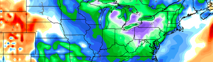
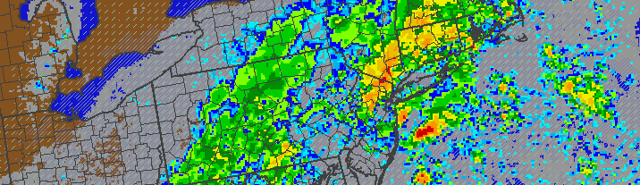
A stretch of pleasant weather over the past several weeks will finally come to an end, as tropical moisture and multiple coastal storm systems bring an increased likelihood of rain.

The pleasant weather, while welcomed, has brought upon Moderate Drought conditions throughout much of New Jersey and New York, with the Department of Environmental Protection recently issuing  a Drought Watch. The rains this week will put a significant dent in the deficits we have built up since late-summer.

Forecast models are in good agreement that a frontal zone will sink toward the area on Tuesday, with enough forcing and lift for precipitation to develop. Making matters even more interesting, a southeasterly flow will aid in the expansion of tropical moisture along much of the East Coast. As all of this occurs, models suggest a low pressure system will develop near the front, aiding in heavier and more widespread rainfall on Wednesday.

Read more

High latitude blocking puts Spring on hold

It’s almost too fitting. For much of the winter, meteorologists and hobbyists alike spend countless hours attempting to forecast and predict the likelihood of high latitude blocking development. This year, stratospheric warming events were expected to kick off changes that would eventually lead to the development of said high latitude blocking, and change our pattern to a cold and snowy one. While the pattern turned cold and snowy for sure, the high latitude blocking never came to fruition. In fact, the NAO stayed positive for much of the winters duration.

Well, it’s finally here. Just in time for Spring.

Read more

Clearing behind front, pleasant Tuesday

After elevated thunderstorms brought a prolonged period of rain, lightning and thunder late Monday Night into early Tuesday morning, clearing is expected from west to east by later Tuesday morning. Drier air will surge toward the coast as an upper level system shifts eastward, and the weather will become much more pleasant. Highs in the 60’s are expected as warm mid level temperatures stick around during the early afternoon hours.

The weather on Tuesday afternoon will likely be the nicest of the week, unfortunately. An active and persistent weather pattern is forecast to continue. Making matters worse? High latitude blocking will force an upper level trough underneath it, into Eastern Canada, bringing colder than normal air to much of the Northern 1/3 of the United States. On Wednesday afternoon, a secondary cold front will cross the area — again with potential thunderstorms — and usher in a much cooler airmass.

Read more

The science behind a wintry intrusion this week

Any time the pattern gets as anomalous as it is forecast to get over the next several days, a meteorologist’s job becomes very interesting. We can either simply say “It’ll be very cold this week”, or we can take the time to explain the science behind it. We’ll choose the latter. The pattern change, which will undoubtedly be noticeable by the middle to end of the upcoming work week, is occurring as a result of several impressive atmospheric events. Global circulations are changing the pattern — and it will be a sight to see. But the change goes far beyond the fact that unseasonably low heights will dip into our area by Thursday morning.

The pattern is already unbelievably anomalous well to our west, over the Northeast Pacific and British Columbia. The extratropical transition of Typhoon Nuri and its phase with a piece of Pacific Energy led to a tremendously anomalous trough — and an incredibly strong storm system with minimum central pressures down to 924mb (The strongest storm in the history of the Bering Sea and the North Pacific). But, more importantly, the anomalous storm system is amplifying a tremendous ridge to its east over the West Coast of the United States, northward into British Columbia and toward the poles.

Read more