-2")

Public Analysis: Cool and Damp Friday, Coastal Cut-Off Next Week?
Good afternoon and Happy Friday!
Today has been another unsettled and damp day as rather thick cloud cover and some associated showers have worked their way through the region late last night and into the morning. This was due largely in part from a retreating back door cold front, or a cold front that sinks from northeast to southeast due to more dense air being able to overcome the more shallow and weak warm layer to the south. Offshore winds and thick cloud cover should remain over the remainder of the afternoon, and there does exist the potential for some patchy areas of drizzle or even a shower or two. Any steadier showers will likely be limited to areas along the coasts of New Jersey and Long Island, as the marine influence will be greatest along those areas.
With this aforementioned cloud cover and the back door cold front established well to our south and west, temperatures in North and Central New Jersey, as well as points to the north will struggle to reach out of the mid 50’s this afternoon. Further south into southern portions of New Jersey as well as southeast Pennsylvania, we may see temperatures reach into the low to middle 60’s, but this is highly dependent on whether or not if the warm sector in central Pennsylvania is able to advance during the late afternoon hours.
Some more steady showers and possibly even a thunderstorm or two may be possible for portions of southeast Pennsylvania as well as southern New Jersey later into this evening, but as of right now, it is looking like any shower /thunderstorm development will be isolated in nature. Weak instability, moderate wind shear, and some clearing skies over central Pennsylvania has lead to an area where we may see these potential showers and storms develop and potentially progress east during the afternoon hours. This area will be monitored for any potential development, so make sure to check in here for the latest and on our twitter page @nymetrowx for up to the minute updates! Due to the risk of some weak/isolated severe thunderstorms, the Storm Prediction Center in Norman Oklahoma has place portions of our area in a Marginal Risk for large hail and potentially damaging wind gusts. Heavy rain and cloud to ground lightning will also be possible with any stronger storms, so make sure to be aware of any approaching storms later on.

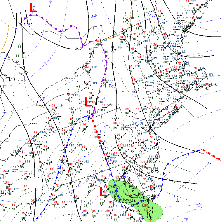
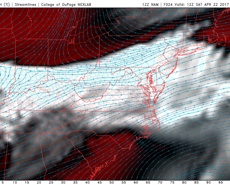
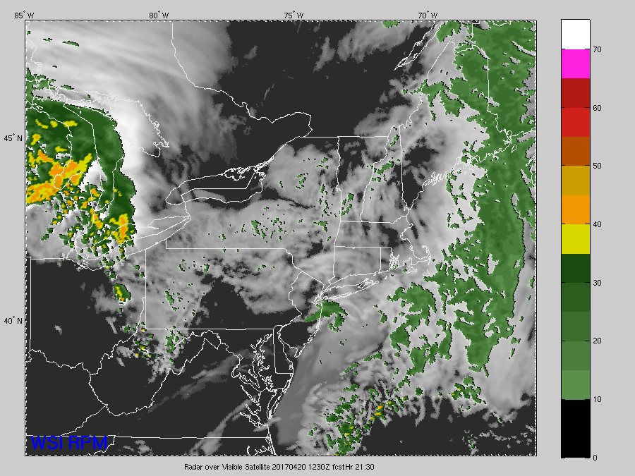
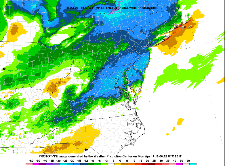
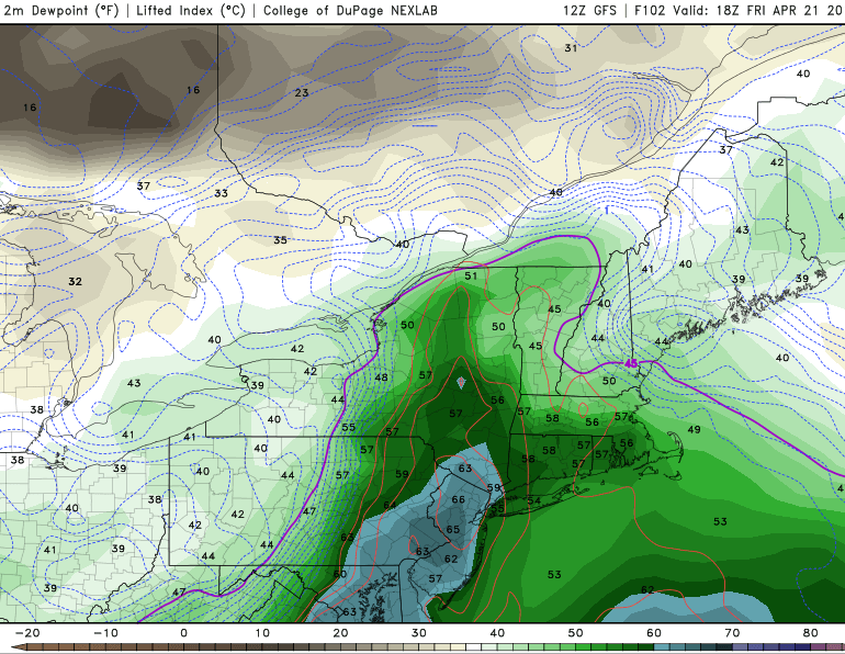
Latest surface temperatures, regional radar mosaic, and visible satellite imagery across the Northeast showing the very stark temperature gradient in place this afternoon (Courtesy of GREarth)
As we move on through the day and into the evening, a cold front will begin to push through the region later this evening. However, there is a chance that some moisture will be trapped in the lower levels of the atmosphere later on tonight, which could cause some low clouds and areas of patchy fog to remain late tonight and early tomorrow morning, especially closer to coast. Cloud cover will significantly dampen any chance of radiational cooling tonight, which should keep temperatures from dropping out of upper 40s to lower 50s overnight over much of the region. Some interior valleys could be a little cooler in the lower to middle 40s, which is a good 8-14 degrees below normal for this time of year.
Saturday Into Sunday
As the cold front continues to push through the southern Mid Atlantic region tomorrow morning, broken clouds and even some overcast will be possible as some residual moisture continues to stick around in the lowest levels of the atmosphere. The short-term models disagree on whether or not the cloudiness will burn off or not through the afternoon hours, but we do expect some peeks of sunshine tomorrow with a relatively cool air mass settling in tomorrow. With some limited cloud cover, light winds, and cooler mid level temperatures expected tomorrow, temperatures should be able to only rise into the low to middle 50’s across most of the New York metro area, with the possibility of interior locations possible seeing highs limited to the upper 50’s due to cool northwesterly winds from Canada. These winds will also usher in some more dry air into the mix, so expect any residual clouds to gradually fade iater into the day.
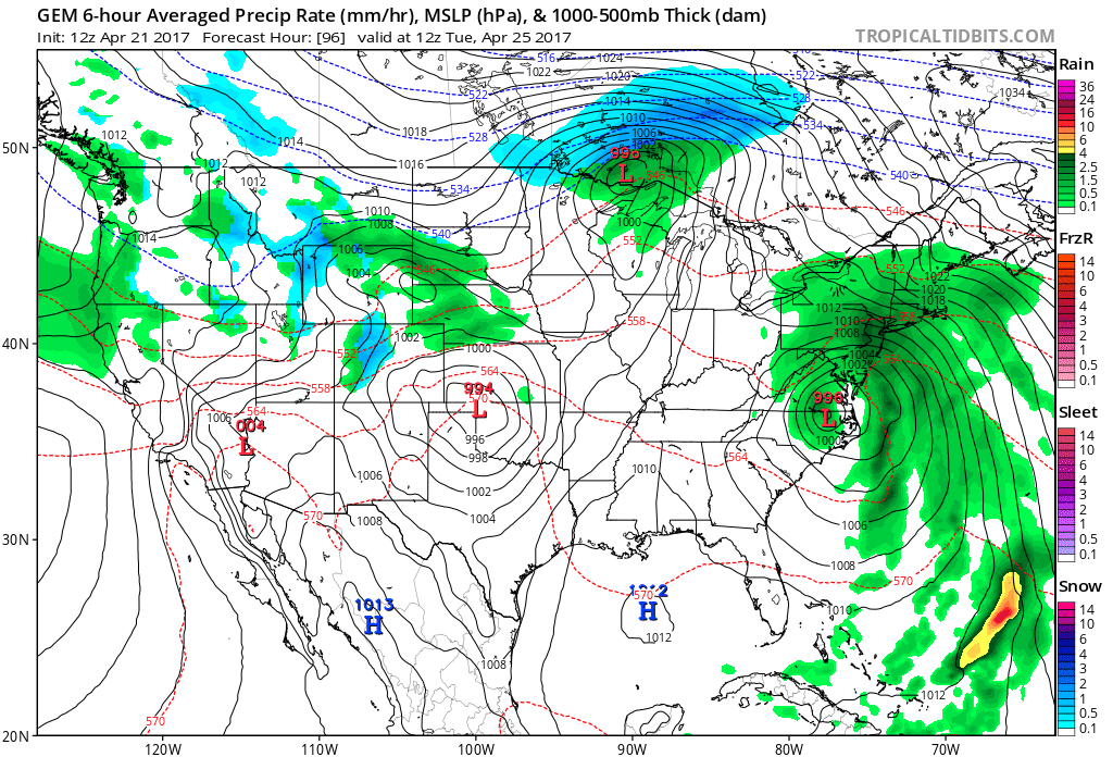
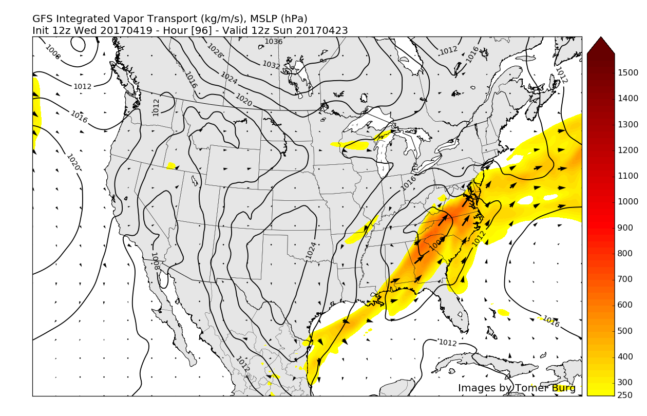
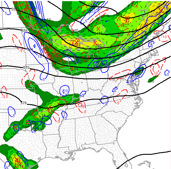
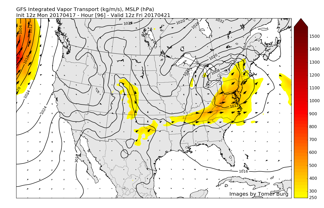
Sunday will be the beginning of another unstable period as a low pressure system in the mid levels of the atmosphere “cuts off” from the main flow and begins to meander towards the southeast coast of the United States. This low pressure will have a very nice feed of moisture from the Gulf of Mexico, so it’s overall precipitation field should be quite large in nature, as well as have the potential to drop a moderate to heavy amount of rain wherever it does track. This afternoons guidance really has not converged on any particular solutions, with some models bringing the low from the Outer Banks of North Carolina, to just offshore of the southern coast of Long Island, while other models have the system meandering off the Mid Atlantic coast with little, if any direct impacts through Sunday and Monday.
As of right now, we expect that this system will not be able to gain enough latitude once it reaches the southeast coast to impact our area with any significant rains or winds at this time. High pressure centered in Canada will likely keep this system offshore throughout this period, but this system will need to be monitored, as a small deviation in overall setup could chance the forecast quite a bit.

12z GFS model showing the large cutoff low pressure system stalling out and remaining off of the Mid-Atlantic coast throughout the weekend and into early next week.
Extended Range
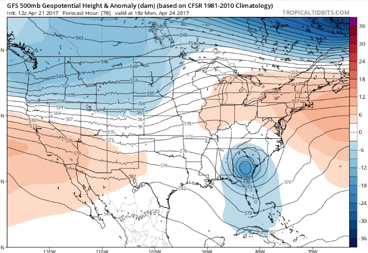
Stronger ridging should begin to develop over our area on Monday and into Tuesday, and this will begin to force the remnants of the cutoff low to the south and east early next week. This should allow any significant impacts like heavy rain and winds to remain well-offshore before the system gradually weakens and heads out to sea. More unsettled weather will likely take shape once again as a very active Pacific jet stream begins to set up off of the west coast of the United States.
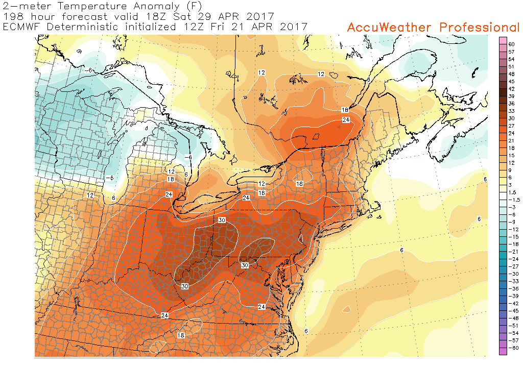
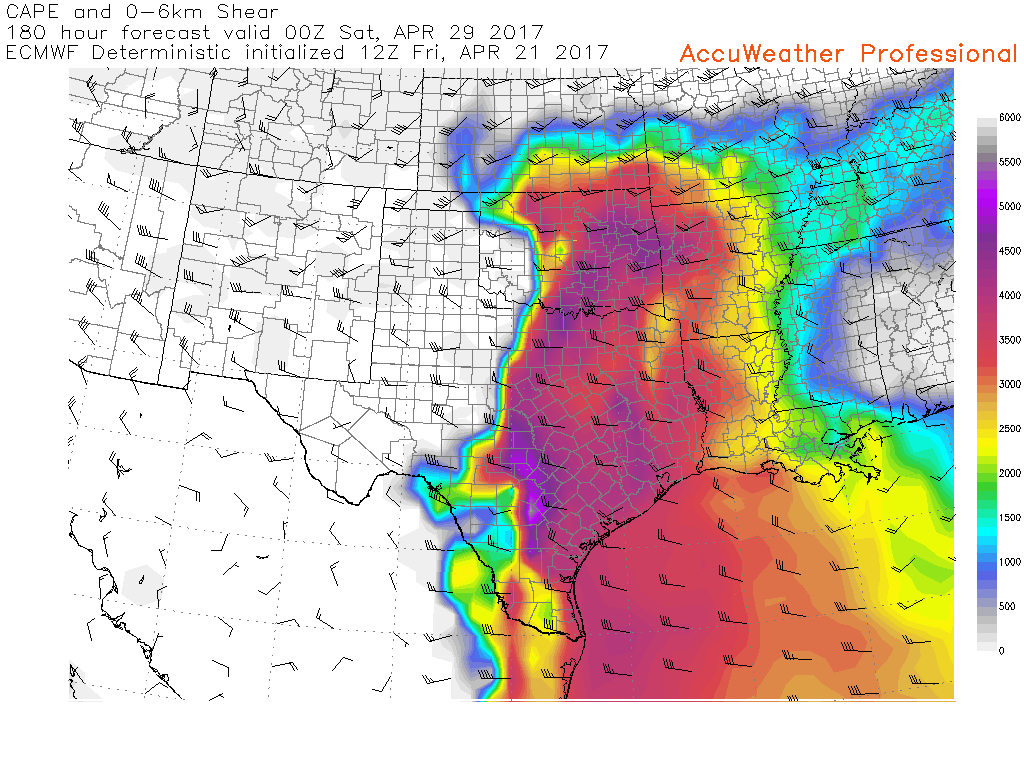
This very active jet stream will have the potential to place a deep trough in the central portions of the country, which would in turn bring a large ridge of high pressure into the southeastern region of the country. This combination would be capable of bringing temperatures well-above normal next week for the Northeast, along with the risk for multiple rounds of severe storms in the Plains states and on east, possibly beginning on Wednesday. Regardless of the exact details, it does look like we are possibly heading into a very active and warm pattern once again, so make sure to stay tuned over the next few days for more updates!
——————
For more information and posts like this one, make sure you sign up for Zone Forecasts — where multiple detailed articles, videos, and interactives are posted each day. Also, come interact with our staff and many other weather enthusiasts at 33andrain.com!
Have a great weekend!
Steve Copertino


