Posts

Cooler, pleasant weather behind cold front

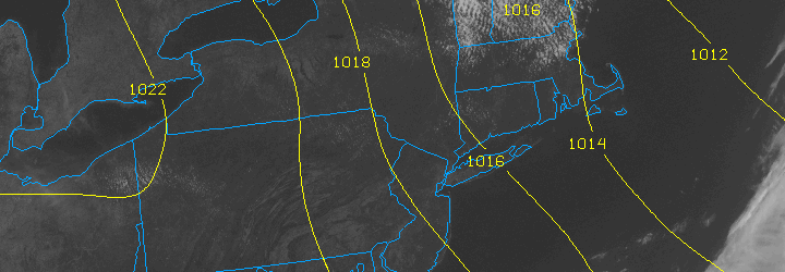
The warm and humid airmass from this past weekend is a distant memory this afternoon, as cooler air with lower dew points has settled into the area. A refreshing northwest breeze will continue for the remainder of the day with high temperatures around average in the mid 70’s. The trend is expected to continue through the middle of the week, with more sun and slightly warmer temperatures on Wednesday — but not hot or humid at all.

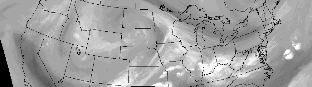
Not all of the news is good, however. The forecast takes a bit of an unsettled turn by late Thursday and Friday and may become quite ugly by the weekend as a tropical moisture feed extends up the East Coast of the United States. Forecast models are showing a trough sinking through the Ohio Valley and Northeast by the weekend, with showers becoming likely with periods of heavy rain also a possibility if a weak surface low pressure system can form offshore.

We’ll keep a close eye on it as the week goes on, but for now enjoy the beautiful weather! Remember to check our social media accounts for frequent updates.

Cooler/Unsettled weather behind big nor’easter

Behind the strong storm system which impacted our area this weekend, the weather will take a turn towards a cooler and slightly more unsettled

GFS Model (4/23/12) showing potential rain and unsettled weather near a warm front next weekend.

pattern. Prior to the system, above normal temperatures and fair weather were dominant, but as it looks now this storm will serve as a bit of a pattern-changer. It doesn’t look like we’ll return to much-above normal departures any time soon. Instead, forecast models are indicative of a bit of a battleground setting up near our area, as a gradient develops in the mid levels of the atmosphere. Such an event would likely mean more chances for precipitation, and temperatures running near normal for this time of year (with, of course, some fluctuations).

This week, showers will be around to start as an upper air trough lingers behind the strong storm system. It looks like high temperatures will warm up a bit as we approach Thursday, where they may spike into the mid/upper 60’s. But shortly thereafter, showers and a cold front will work back into the forecast, and bring cooler weather again for the weekend ahead. Pictured right: GFS model showing a “gradient” near our area later this week and this weekend. On the left, we see the mid-level heights in the atmosphere, and on the right, we can see the 6 hour precipitation and 850mb temperatures. Notice the temperature gradient near our area and precipitation near a warm front.

Article written by JH. Published April 23rd, 2012 at 1:30pm. For up to the minute details on forecasts, watches, warnings, and alerts, follow us on Twitter and Facebook.