In a winter which has generally been defined by light snow events and fluctuating temperatures, this coming Wednesday could provide a continuation of the theme. A clipper system dropping south and east from Canada is likely to bring the potential for light snow on Wednesday as it moves through the Mid Atlantic states and eventually to a position off the Mid Atlantic Coast. Precipitation is expected to be generally light, but the potential exists for a few inches of snow before all is said and done.
What will become more difficult to forecast is the areas where bands of more steady snow will develop. Forecast models have jumped around considerably in regards to the area where these bands will set up. Confidence, currently, is highest in snowfall totals from 1 to 3 inches throughout the forecast area, with an outside chance of higher amounts underneath those steady bands.
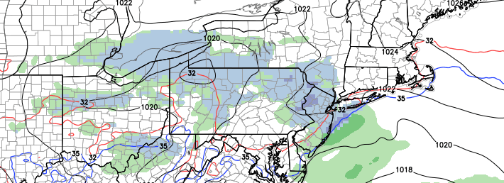
Forecast model guidance has come into good agreement on the eventual track and intensity of a winter storm which is forecast ot impact the area from Tuesday through Wednesday. The system was initially forecast to develop well seaward, but guidance over the last 24 to 48 hours has trended more amplified, slower and stronger with the storm system. The result is a moderate impact winter storm which is expected to begin during the afternoon on Tuesday and continue into Wednesday morning. A mid level disturbance dropping south from the Northern Plains will eventually amplify in the Mississippi Valley before moving off the East Coast, helping to develop a surface low and a nor’easter overnight into Wednesday morning.
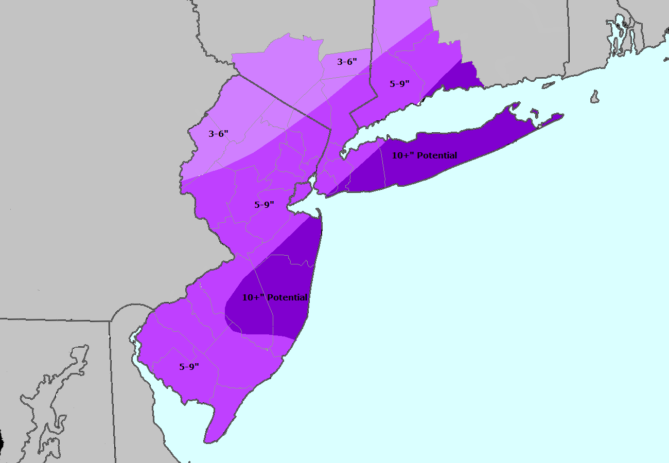
It is the exact track and intensity of this low pressure which forecast models have struggled with. But newer guidance agrees that the placement and development of the system will support widespread snowfall through the area. Heavier bands of snow and wind are likely from the I-95 corridor south and east, with highest snowfall totals expected near the area coasts of New Jersey and Long Island. These bands, however, remain unpredictable and can often wind up impacting other areas despite what forecast guidance suggests. Below, we have included our 411 on the storm system including expected totals, timing, and information as well as a snowfall forecast map. Later tonight, we will issue a new set of products including hazards briefings and other information.
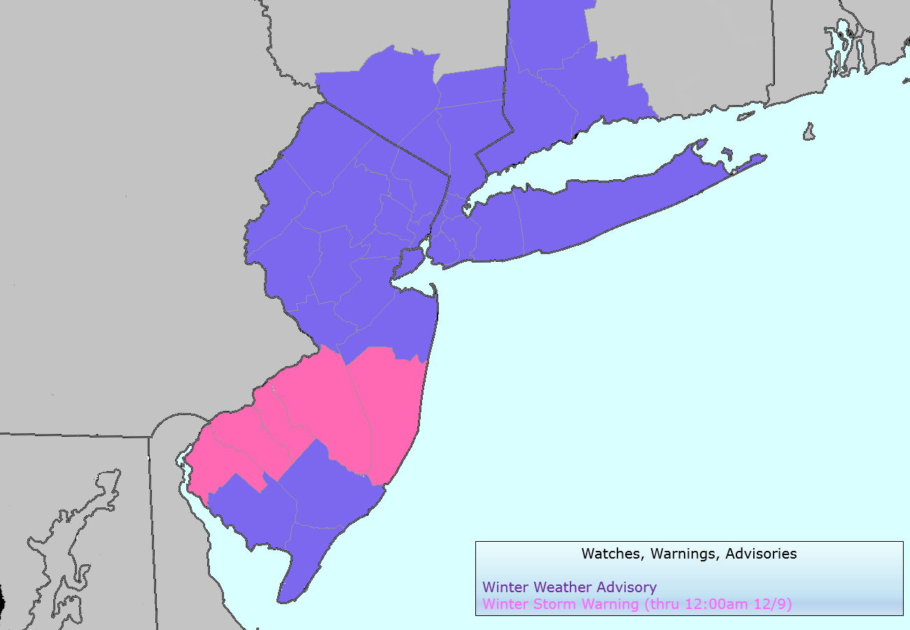
The National Weather Service issued Winter Storm Warnings and Winter Weather Advisories for the entire area on Monday evening, in advance of a light to moderate snowstorm which is expected to impact the area on Tuesday. The Winter Storm Warnings, in effect through 6pm on Tuesday evening, cover much of Southwestern and Central New Jersey as well as the major cities of Philadelphia and Trenton. Elsewhere, Winter Weather Advisories are in effect for the rest of New Jersey, New York City, Southwest Connecticut and Southeast New York. The advisories currently do not include Eastern Long Island or interior New York State.
The watches and advisories were issued in advance of a forecast snowstorm, which will approach the area on Tuesday. A mid level disturbance sliding eastward, and a frontal boundary providing the focal point for enhanced lift and development of precipitation, will set the stage for the event. A band of moderate to heavy snow is forecast to develop by late Tuesday morning, but forecast models have been struggling with the exact placement of the band. Regardless of that bands eventual position, 1-3″ of snow seems increasingly likely throughout the majority of the region. But the heavy snow band, and enhanced forcing within it, provides extra intrigue for potential higher amounts. We break down Tuesday snowfall event with timing, snowfall totals, and hazards information below.
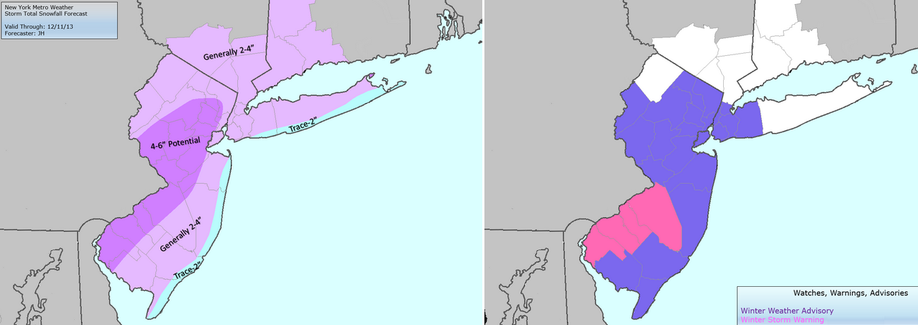
Storm total snowfall forecast (left) and NWS Watches, Warnings and Advisories (right).
Several inches of snow fell earlier today across parts of Southeast Pennsylvania, into Southern and Central New Jersey as a mid level disturbance triggered precipitation — which fell along a gradient between warm air advection to the south, and cold and dry air to the north. The combination lead to an enhanced frontogenesis event, with bands of heavy snow lasting several hours during the day on Sunday. Snowfall totals within warning criteria (over 6″) fell in parts of Delaware, Pennsylvania and New Jersey by the time the snow let up. Farther north, closer to Northern New Jersey and New York City, the drier air won the battle. A half inch or so of snowfall fell before precipitation entered a lull on Sunday evening.
Which is where we pick up — with a break in precipitation occurring throughout the area this Sunday evening. Warm air advection, however, is ready to come back for more — with additional precipitation expected to develop by later tonight into Monday morning. As the warm air advection helps to drive precipitation farther north, it will also warm the mid levels of the atmosphere — allowing for a gradual changeover in precipitation type throughout the area. Winds turning from northeast to southeast by later tonight will also warm the surface, especially along the coast. Although another period of snow is likely, it should be somewhat brief in the city and near the shore before transitioning to sleet and plain rain. Farther inland, a period of frozen precipitation is expected as well before a changeover. It is the far northern suburbs which may still experience a more prolonged period of snow and sleet — with the potential for 1-3″ of snow and sleet by Monday morning.
NAM model showing mixed precipitation accumulations through Monday morning — freezing rain, sleet, snow and rain.
The National Weather Service continues Winter Weather Advisories throughout much of the area through 3:00am (New York City and coastal areas) and 6:00 am (Interior suburbs of New Jersey and New York). Travel this evening will be slick, with areas of ice and snow on all roads. This will be less of an issue near the coast and in the 5 Boros, especially with the lull in precipitation allowing for crews to treat the roads. Inland, colder temperatures and another period of wintry precipitation suggest that the morning commute may be messy.
National Weather Service watches, warnings and advisories valid from Sunday Night into Monday morning
Hi friends! Our website uses cookies to provide an optimal browsing experience for you. New "Cookie Consent" laws mandate us to inform you of this. As long as you're cool with it, just hit OK. You'll only see this message once.
We may request cookies to be set on your device. We use cookies to let us know when you visit our websites, how you interact with us, to enrich your user experience, and to customize your relationship with our website.
Click on the different category headings to find out more. You can also change some of your preferences. Note that blocking some types of cookies may impact your experience on our websites and the services we are able to offer.
Essential Website Cookies
These cookies are strictly necessary to provide you with services available through our website and to use some of its features.
Because these cookies are strictly necessary to deliver the website, refusing them will have impact how our site functions. You always can block or delete cookies by changing your browser settings and force blocking all cookies on this website. But this will always prompt you to accept/refuse cookies when revisiting our site.
We fully respect if you want to refuse cookies but to avoid asking you again and again kindly allow us to store a cookie for that. You are free to opt out any time or opt in for other cookies to get a better experience. If you refuse cookies we will remove all set cookies in our domain.
We provide you with a list of stored cookies on your computer in our domain so you can check what we stored. Due to security reasons we are not able to show or modify cookies from other domains. You can check these in your browser security settings.
Other external services
We also use different external services like Google Webfonts, Google Maps, and external Video providers. Since these providers may collect personal data like your IP address we allow you to block them here. Please be aware that this might heavily reduce the functionality and appearance of our site. Changes will take effect once you reload the page.
-2")