Posts

Clouds, drizzle will give way to a warm Thursday


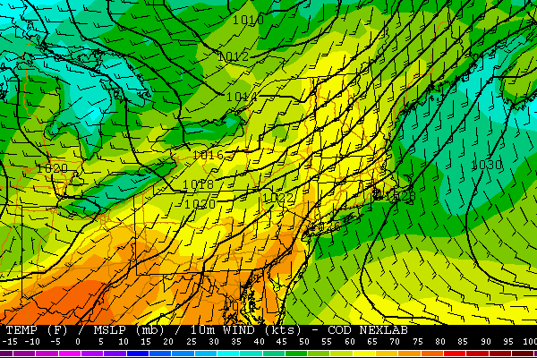
Spring 2013 certainly has not been “warm” by definition, with plenty of transitions and colder than normal airmasses moving through the Northern tier of the United States. There have, however, been a fair share of warmer than normal days — with several featuring high temperatures well into the 70’s across parts of New Jersey and New York City. Thursday will be another one of those days.

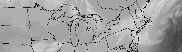
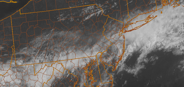
With a warm front moving through the area, some clouds and spotty showers are expected through the morning hours. With time, these clouds will burn off and give way to partly cloudy skies. Temperatures will rise into the mid to upper 70’s throughout much of the area, with parts of New Jersey potentially approaching the lower 80’s. A frontal zone moves through later Thursday Night with a period of clouds (but little precipitation expected), and Friday will end up several degrees cooler — but still pleasant with highs in the lower 70’s.

The main noticeable change will be the wind direction, as west-southwesterly winds on Thursday will give way to northerly winds behind the front on Friday. Looking ahead, some more unsettled weather with showers and storms is expected as we move into the weekend. Details on the weekend forecast are forthcoming in a blog post later this evening!

Warmer air, some clouds on the way for midweek

The typical ups and downs of springtime weather have arrived, despite a very slow start with colder than normal temperatures through much of March and the first few days of April. After a big warmup last week, cooler air took over this past weekend with a bout of cold rain and cloudy conditions. However, warmer air is on the way once again as a storm system moves through the Central United States. Tuesday will mark the first “warmer” day of the few, but this one will be slightly more tempered compared to last week with a frontal boundary hanging around the area.

NAM model showing forecast high temperatures throughout the area on Tuesday afternoon. Notice the warmer temperatures, in the 70's over New Jersey. The southeast winds off the water keep temperatures in the 60's along the shore.

NAM model showing forecast high temperatures throughout the area on Tuesday afternoon. Notice the warmer temperatures, in the 70’s over New Jersey. The southeast winds off the water keep temperatures in the 60’s along the shore.

In addition, a more southeasterly component to the wind will ensure that coastal areas remain at least somewhat cool. Clouds and some fog are expected in the morning on most days this week with the potential for showers as the front nears on both Wednesday and Thursday. In general, however, temperatures will rise into the upper 60’s to lower 70’s especially over New Jersey and working towards New York City. Areas east of New York City and along the shoreline will have more trouble reaching those numbers.

Tuesday: Partly cloudy with highs in the upper 60’s to lower 70’s. A chance of showers. Mostly cloudy and fog early, lasting into afternoon along the shore. Southeast winds around 10 miles per hour. Chance of precipitation is 20%.

Tuesday Night: Mostly cloudy with a chance of showers and thunderstorms. Low in the 50’s. Chance of precipitation is 50%.

Wednesday: Partly cloudy with highs in the upper 60’s to lower 70’s. A slight chance of showers. East-southeast winds around 10 miles per hour. Chance of precipitation is 20%.

Fair weather on the way in wake of nor’easter

Water vapor satellite imagery early Tuesday morning, showing the strong coastal system moving away to the Northeast and calmer, drier weather approaching.

Water vapor satellite imagery early Tuesday morning, showing the strong coastal system moving away to the Northeast and calmer, drier weather approaching.

A late season winter storm impacted the area on Monday, with less flair than originally expected. Warm ground temperatures (and warm air temperatures during the day) combined with light precipitation rates to keep it mainly a non accumulating snow event in Northern NJ and New York City. Dry air won the battle over precipitation farther north over Connecticut and Southeast New York. Farther south, over Central and Southern NJ, a few inches of snow were observed through Monday evening. The brunt of the storm (as far as heavy banding and the low pressure center), however, remained barely offshore. In the end, the storm system will likely be remembered as a “near miss for the area”. As we move forward into the week, a moderating trend in temperatures and dry weather are in the forecast — and it should at least begin to feel a bit more like Spring.

Cool air will hang on initially, with some clouds and a slight chance of showers on Tuesday. High temperatures in the upper 40’s, approaching 50, are expected. Cool nights will still be present with lows in the 20’s and 30’s — so don’t put away the coats just yet. Additionally, the cold air is still present to our north (owing to the big blocking and historically negative AO we experienced last week), so that could take a while to shake. By late this week into the weekend, high temperatures are expected to reach into the 50’s. I think it’s safe to say we are all looking forward to it.

Tuesday: Partly sunny with a high in the mid to upper 40′s. Northwest winds around 10 miles per hour. A slight chance of showers in the afternoon.

Tuesday Night: Mostly clear and cool with lows in the upper 20′s to middle 30′s. Northwest winds 1o to 15 miles per hour.

Wednesday: Mostly sunny with a high in the mid to upper 40′s. West winds around 10 miles per hour.

Thursday: Mostly sunny and feeling warmer with a high in the mid to upper 40′s to near 50. Overnight low in the mid 30′s.