Posts

NYC Forecast: Slow warming trend this week

Cold weather has become a staple in the area forecast over the past several days, with the only warmup coming during a significant storm system — which produced the first rainfall of over 1″ since September in New York City. Otherwise, though, it has been a cold and dry pattern which has dominated the past several weeks. Some changes are in order during this week, but the start will be characterized by a slight warmup. Monday will be the first of a few “warmer” feeling days, with highs in the 40’s to near 50 in many spots as well as plenty of sun.

During the week, the airmass will slowly modify as a high pressure continues to control the pattern. High temperatures will reach into the upper 40’s and lower 50’s by the middle to second half of the work week. With the warmup, will come a chance of precipitation and the likelihood of clouds, which will move into the area as a warm front moves nears on Thursday.

NAM model, forecasting high temperatures in the upper 40's to lower 50's on Monday.

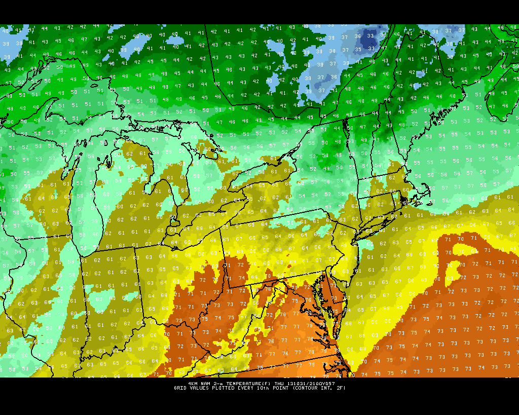
NAM model, forecasting high temperatures in the upper 40’s to lower 50’s on Monday.

Read more

Weekend warmup will feature unsettled weather

Much has been made of the cold and snowy weather this week, and rightfully so. Temperatures fell into the teens and 20’s on Wednesday night after snow on Tuesday, and high temperatures Wednesday afternoon barely scraped into the upper 30’s. Those temperatures are more typical for overnight lows this time of year. But there is another story line in the weather pattern, and it is one that will certainly keep appearing until there is a large scale change: the pattern is progressive. In the mid and upper levels, the pattern shows no signs of slowing down, meaning any airmass that settles into the area (no matter how anomalous) won’t meander around for long.

Not surprisingly, the very cold air which moved through the area early this week is well out of the picture. Temperatures will warm into the upper 50’s on Friday and the warming trend will continue through the weekend. Along with the warmup, unfortunately, will come some unsettled weather. As a mid level ridge builds over the Central and Eastern US, multiple disturbances will ride eastward through the Mid Atlantic states. The result, in terms of sensible weather, will be increased potential for clouds and showers on both Saturday and Sunday — but not a washout.

NAM model showing multiple disturbances moving into the Mid Atlantic states this weekend. Image courtesy weatherbell.

NAM model showing multiple disturbances moving into the Mid Atlantic states this weekend. Image courtesy weatherbell.

Read more

PM Update: Pleasant, warming trend begins midweek

The cooler than normal weather which has dominated the pattern over the past week or so will take a brief respite over the next few days, as a storm system surges towards the Central US and brings a warm front towards the region. In the meantime, pleasant weather is expected tonight — with temperatures falling from the middle 50s into the 40s overnight.

NAM model showing high temperatures in the middle to upper 60's throughout the area on Halloween (Thursday).

NAM model showing high temperatures in the middle to upper 60’s throughout the area on Halloween (Thursday).

Read more

Sun, warmer air return for midweek

A low pressure system scooting quickly off the coast of Long Island has kept some clouds and showers around early this morning, mainly over New York City and eastward through Long Island. Water vapor satellite imagery (pictured above) shows drier air moving in behind the aforementioned low pressure system, diving southward from New York State and Pennsylvania. The result will be clouds giving way to more sun by this afternoon, as the low pressure moves eastward well off the coast.

In addition to the drier air and northerly wind component this afternoon, warmer temperatures will move in aloft. Forecast models indicate 850hPa temperatures increasing from 12-14c this morning to 15-17c by this evening. High temperatures this afternoon will approach the middle to upper 80’s in many areas, and will be warm even down to the area beaches thanks to the north winds. What starts out as a cloudy day across the east end, will turn into a gem of a Tuesday for the majority of the forecast area. Enjoy!

Today: Partly to mostly cloudy skies will give way to plenty of sun, north winds, and highs in the middle to upper 80’s. A tremendous late-summer Tuesday is on the way. No weather hazards or weather-related travel impacts are expected.T

Tonight: Partly cloudy skies return, and pleasant weather is expected early. However, a few isolated showers cannot be ruled out in the late evening to overnight period. Low temperatures falling into the upper 60’s to lower 70’s.