Posts

Cool, damp weather will lead into a warmer weekend

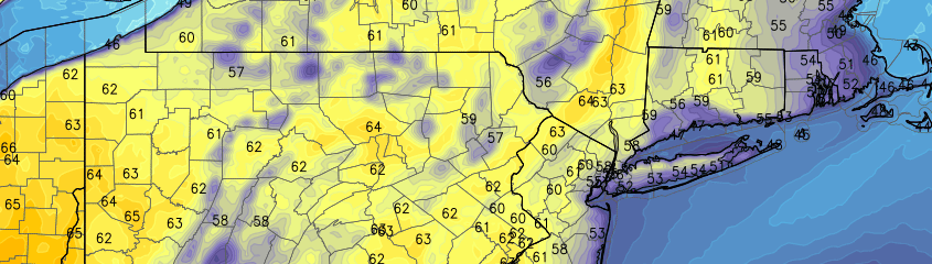
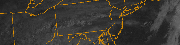
A developing coastal storm will keep the weather cooler and more damp today, as Thursday will become the “stinker” of the week so far. Clouds and showers moving toward the area are the initial developmental signs of a coastal storm, which will luckily develop well offshore. But cooler northeast winds and clouds will keep temperatures in the 50’s and 60’s on Thursday. As the storm develops, sinking air in our area will kill the development of showers and bring steadier rain closer to the coastal storm offshore, allowing for some clearing by Thursday evening and a better weather day on Friday.

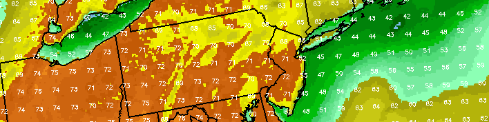
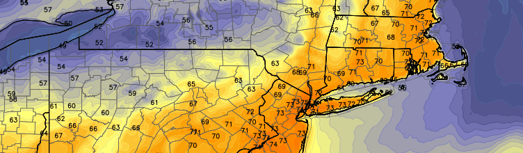
The long-awaited Memorial Day weekend, luckily, looks to feature improved weather over what we will have experienced on Thursday. Westerly winds will begin to usher in a much warmer airmass for the weekend — initially on Friday featuring temperatures in the mid to upper 70’s. A weak frontal boundary approaching the area Friday afternoon will touch off some showers and thunderstorms, but they won’t be a harbinger of anything bad to come. Saturday and Sunday both look to feature pleasant, seasonable weather which will warm each day.

Read more

PM Update: Slightly cool, but pleasant evening

Behind a backdoor cold front, which pushed through the area on Wednesday evening, temperatures stayed cooler on Thursday. A cool, onshore flow can be thanked for that. Luckily, most of the clouds which plagued the area during the early part of the day will move out during the later evening and overnight hours of Thursday, so a generally pleasant evening is expected. Any scattered shower and thunderstorm activity will remain off to our southwest, in the Mid Atlantic States.

Temperatures, however, will stay cool and the onshore flow will continue pushing marine air into the area. This is often a relentless characteristic of Spring in these parts, but it doesn’t make it feel any less chilly! Temperatures will fall into the 40’s overnight Thursday into Friday morning, with east/southeast winds continuing through Friday.

Read more

Warmer, but unsettled weather through the weekend

We’ll start off by saying this: Saturday will be the winner of the weekend, with highs in the 70’s even near the coast. The rest of the weekend, however, will remain unsettled. Multiple mid level disturbances crossing from the Central to Eastern United States, and the return of increased moisture, will lead to the chance of showers and rain both on Friday and Sunday afternoons. This leads to an uncertain temperature forecast, but increasing likelihood of unsettled weather both days will certainly hamper the weekend weather a bit.

Wednesday and Thursday, first, look to be exceedingly pleasant. Highs on both days will reach into the middle 60’s with generally light winds, and plenty of sunshine. If you’re headed to Madison Square Garden on Thursday afternoon and evening for the Rangers/Penguins Game 1 (we’re big Rangers fans here), the weather should be perfect. You might even be able to grab dinner outside or on a local rooftop restaurant before the puck drops at 7pm.

After high pressure gives way to a weak disturbance on Friday, which will bring increased clouds and chance of showers at times during the day, re-established high pressure will briefly take over on Saturday. West/northwest winds and warmer temperatures aloft will allow for highs to reach into the 60’s and 70’s during the afternoon hours on Saturday.

Read more

Pleasant week ahead, save a rainy Tuesday

It has been a while since residents of the Tri-State Area have been able to look ahead at a weekly forecast without worrying about a major storm system. While this week will feature one day of unsettled weather, on Tuesday, the general theme will be pleasant — and Spring like, too. A high pressure system will hold on to just enough control of the atmospheric pattern Monday, allowing temperatures to rise into the 60’s and 70’s amid a modifying airmass. Southerly winds will actually kick up throughout the day a bit, but they will be warm — and highs may reach the 70’s in parts of Central and Northern New Jersey.

An approaching cold frontal system will bring showers and a rumble of thunder on Tuesday, but temperatures will rise into the 60’s during the morning out ahead of the frontal system. Clouds and showers will be prevalant throughout the day. But while rain will obviously hamper the forecast, it certainly won’t be a cold or dreary washout by any means. Once the frontal system comes through, clouds will clear out once again by Tuesday Night and the airmass will become refreshed with cooler temperatures aloft.

Read more