Memorial Day Weekend could offer taste of summer

The rainy and dreary weather which has plagued the area quite frequently over the past few weeks will continue through the middle of this week, but

GFS Model forecasting a large ridge in the Eastern US on Memorial Day Weekend, ushering in a warm airmass.

it appears that the forecast models are beginning to hint at the potential for a turnaround in temperatures and sensible weather by Memorial Day Weekend. A large trough diving towards the West Coast on some of the major forecast models would help force the development of a large ridge on the East Coast of the United States, ushering in a much warmer airmass — possibly the warmest we’ve seen so far this season. However, the intensity of the heat and the ability for it to reach our remains in question. Forecast models have been fluctuating with the northward reach of the “real” heat (temperatures over 90 F), so we’ll have to keep a close eye on it. That said, we’re definitely looking at the potential for some real summer-like days in the near future!

Along with the potential for heat, will come the potential for thunderstorms. Typically, along the periphery of these big heat-ridge set-ups, thunderstorm systems can form and track for relatively long distances. Often referred to in the meteorological community as the “ring of fire”, these complexes of storms can often provide a strong punch. However, the exact setup (positioning/strength of the ridge) will determine where the thunderstorms track. Some of the forecast models are hinting at impacts in our area — but we’ll watch it carefully!

All in all, the pattern looks to take a bit of a turn towards a more summery feel over the next week for sure. Stay here for all the details as we get closer.

TS Alberto forms off South Carolina Coast

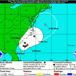
The National Hurricane Center officially declared the formation of Tropical Storm Alberto this afternoon, marking the first named system of the 2012 Alberto 5 Day ConeAtlantic Hurricane Season. The storm system is located off the coast of South Carolina, and is expected to move slowly over the next 24 hours before accelerating northeast up the East Coast (but remaining offshore). Maximum sustained winds as of Saturday afternoon were 40 kts (or 45 miles per hour), and Alberto had a minimum central pressure of 1007 millibars. The system was moving southwest at 3 kts (3 miles per hour). The National Hurricane Center’s cone of uncertainty (right) includes some of the forecast area, including the New Jersey Shore. We aren’t currently expecting the storm system to landfall in our area, but being in the cone of uncertainty generally suggests that interests in that area should keep a very close eye on the forecast over the next few days for any shifts or adjustments.

The expected track of the storm system suggests our forecast area could feel some prolonged impacts from the system. The storm system is not particularly strong, nor is it expected to impact our area directly. However, showers and thunderstorms associated with Alberto are expected to impact the area beginning on Monday. Some periods of heavy rain and gusty winds are certainly possible Monday through Tuesday with the scattered showers/storms. Widespread heavy rain, flooding, or severe weather impacts are not expected.

Stay tuned over the next day or two for constant updates and information on the tropical system and impacts expected in our area.

Heavy showers and strong storms possible Wednesday

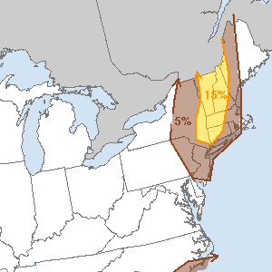
SPC Day 2 Outlook for Wednesday. "15%" chance of severe storms trigger a categorical "Slight Risk".

A moist southerly flow advecting tropical like air into the area has been responsible for a big increase in dew points throughout the area — and a humid airmass in place late Tuesday. This airmass will remain in the area through Wednesday afternoon, when a disturbance will pass to the north of the area. Although the system isn’t overly strong (in fact, it’s pretty far away from the NYC area), just enough energy in the atmosphere will touch off showers and thunderstorms ahead of a cold front Wednesday afternoon and evening. The combination of an unstable atmosphere, forcing/energy near the front, and adequate wind shear will support the development of showers and thunderstorms some of which could be strong or severe. Accordingly, the Storm Prediction Center has placed portions of the area in a ‘Slight Risk’ for severe thunderstorms on their Day 2 Outlook Wednesday afternoon and evening.

The wind shear will be more supportive of storm organization to the north of the city, so we agree with the Storm Prediction Center’s visual outlook…which keeps the entire area in a risk for severe thunderstorms, but signals that the most organized potential will be just north of the city into New England. However, interests in the entire area should keep an eye to the sky Wednesday afternoon. The storms will be capable of producing the usual heavy rain, lightning and thunder…along with the potential for some strong wind gusts and some isolated hail. The threat will end later Wednesday evening as the front passes.

Stay tuned for more updates as the event draws closer — and on Wednesday, for watches and warnings should they be needed.

Beautiful weekend weather will continue

May began as April ended, with a streak of slightly below-normal temperatures and plenty of showers around the area. To be fair, it hasn’t been a total

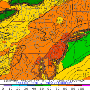
NAM Model showing high temperatures in the 80's on Sunday

washout. Still, the change in weather from what we were experiencing about a month ago today has been rather dramatic. Temperature departures would run over 10 degrees above normal by the middle of April, and through may we have averaged near normal with some areas slightly below normal. The good news, however, is that the showery weather is on the way out. The cold front which was near the area Tuesday and Wednesday has been swept offshore and to our east — and after a cool and windy day Thursday, temperatures rebounded the first half of the weekend.

Temperatures in the middle to upper 70’s on Saturday will give way to more 80 degree temperatures away from the shore on Sunday. Temperatures could rise into the upper 70’s even near the shore during the early hours of Sunday afternoon. However, a seabreeze by afternoon looks to lower temperatures by early evening near the beaches and the local waters. Inland, temperatures in the 80’s could continue to sunset.  The pattern won’t stay overly warm, though, as a trough is expected to work back into the area by next week. Although it won’t be too strong (rather broad, actually) some showers and a bit of unsettled weather is possible during the week once again. Steady rain may work into the area by late Tuesday into Wednesday. We’ll keep an eye on it!

Remember to keep an eye on our 5 day forecast graphic, hazards table, and forecast briefing by using the navigation table to the left. You can also check out a quick glance at the forecast by glancing to the right at our forecast at a glance widget.