Cooler weather returns mid-week

The hot and humid conditions which dominated the areas weather on Memorial Day weekend is in the process of being flushed out of the area, as a
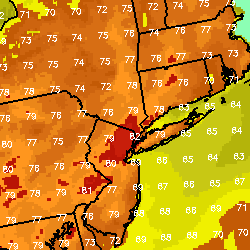
Forecast high temperatures on Wednesday are in the upper 70's to low 80's, much cooler than the past several days.

pre-frontal trough and then surface cold front  move through the area by mid-day on Wednesday. Showers and thunderstorms impacted the area Tuesday evening (albeit weaker than the severe weather which affected much of the interior Northeast), and temperatures dropped from the low 90’s into the low 70’s throughout the area fairly rapidly. The surface front remained to the west, but is expected to cross the area later Wednesday. The large ridge in the atmosphere responsible for the very warm and moist flow of air into the area is no longer in place, and is being replaced with lower heights and an incoming trough.

The result will be cooler weather, and after a chance of some scattered showers/storms on Wednesday, fair weather until Friday. Temperatures in the 70’s to near 80 are expected, but lower humidity levels will make the air feel quite refreshing. However, a low pressure system approaching looks to bring a dreary start to the weekend on Saturday. We’ll keep you updated on the exact timing of the rain as we get closer to the end of the week, but it certainly doesn’t look like the entire weekend will be a washout. For now, enjoy the return to more normal temperatures and fair weather this week.

Severe Thunderstorm Watch for the Tri-State until 10pm

The Storm Prediction Center has issued a Severe Thunderstorm Watch for parts of New Jersey, New York, Pennsylvania, and Connecticut which is

Storm Prediction Center Severe Thunderstorm Watch #318 is valid until 10:00pm for the area outlined in blue.

valid through 10:00pm tonight. A line of showers and strong thunderstorms is currently located over Eastern Pennsylvania, and is moving eastward around 30 miles per hour. These storms are progressing into a moderately unstable environment over our area — supportive of the continued potential for heavy rain, lightning, damaging winds, and hail. One potential mitigating factor is the lack of supportive shear for more organized severe storms, but the potential looks to continue regardless…even though it may lessen some as the storms approach the coast and venture away from the supportive shear values.

Threats… The potential exists for damaging winds, large hail, and frequent lightning in these storms. In addition, very heavy rain and torrential downpours are likely as the storms move through the area. The storms will likely begin moving through the area quickly, so keep an eye to the sky at all times through tonight.

Timing… The storms will likely impact New Jersey between the hours of 7-8pm, and begin accelerating eastward, impacting Southeast NY, New York City, Long Island, and Southeast NJ between 8-9pm. Thereafter, the storms may impact Long Island before 10pm when the severe thunderstorm watch expires.

Strong/severe storms possible Tuesday evening

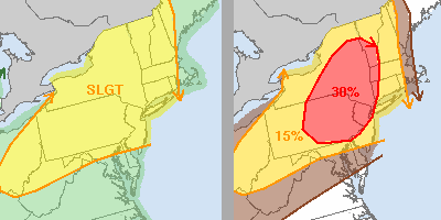
The Storm Prediction Center’s updated outlook has placed the entire NYC Metro Area in a “Slight Risk” for severe thunderstorms through Tuesday

Day 1 Severe Weather Outlook from the Storm Prediction Center for 5/29/12. The categorical risk (left), and the percentage of severe wind gusts within 25 miles of point (right).

evening and into the early hours of Wednesday morning. In addition, the outlook includes a locally enhanced threat (30% chance within 25 miles of a point) of damaging wind gusts and large hail. The threat of storms this afternoon and evening comes in advance of a pre-frontal trough (not the actual surface cold front, but a triggering mechanism ahead of it) which will move through the Northeast US and then off the coast, before the  main surface cold front sweeps through on Wednesday. Some potential mitigating factors to the potential for organized severe weather include the late timing of the pre-frontal trough (may not sweep through the area until early evening, where surface instability will be less)…and somewhat of a lag of supportive shear for more organized storms (the best shear seems to be lagging behind the pre-frontal trough which is triggering the storms today).

Still, the threat does exist for strong to severe storms later this afternoon and evening and our area has been included in the enhanced risk area for these storms to produce strong winds and hail. The Storm Prediction Center may issue severe thunderstorm watches later this afternoon — in which case this post will be updated to reflect the watch in effect. Stay tuned.

Showers & storms possible through Wednesday

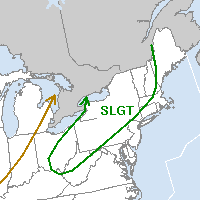
Summer-like weather settled into the area this Memorial Day weekend, with temperatures soaring above the 90 F mark in several locations on

Storm Prediction Center's Day 1 Outlook showing a "Slight Risk" for severe thunderstorms to our west/northwest over the interior Northeast.

Monday afternoon. A large ridge in the mid levels of the atmosphere was the culprit for the hot weather. Thus far, our area has avoided a widespread threat of showers and thunderstorms, although some areas did receive copious amounts of rain in the isolated storms over the past few days. The coverage of these storms, however, has been low. As Memorial Day weekend becomes a memory, a cold front will approach the area on Tuesday…setting the stage for the entrance of more unsettled weather. Showers and thunderstorms could impact the area by afternoon — but again, the coverage of the event remains in question. Forecast models have been too aggressive in showing thunderstorms so far this weekend, so we’re approaching this event with some caution. But it seems like a good bet that, at the very least, some showers will move through the area as the weak pre-frontal trough sweeps through.

The actual surface cold front won’t move through until early-afternoon on Wednesday (maybe a few hours earlier, depending on the speed of the front) — so we could potentially see scattered showers and storms until then. The Storm Prediction Center placed a good portion of the Northeast US in a Slight Risk for Tuesday — but this does not include the New York City area. The shear usually required for organized severe thunderstorms is once again lacking — supporting the idea that the storms will not pose a threat for organized severe weather. However, it will still be warm ahead of the front on Tuesday. Forecast models are indicative of temperatures approaching the 90 F mark once again in some locations (the mid-upper 80’s for sure) before the showers and storms enter the picture.

Stay tuned for updates on the potential showers and storms, as well as updates on any isolated strong thunderstorm threats..including the relay of watches and warnings from the Storm Prediction Center and local National Weather Service.