Forecast: Unsettled weather on the way

Transitional weather has been the theme over the past few weeks, buckling the trend of the consistent above normal temperatures and below

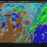
"NAM" Model's simulated radar for Tuesday Night at 8pm, showing moderate rain throughout the area.

normal precipitation which dominated the areas weather for several weeks prior. Much of the same will continue as we move into the second week of May, as an upper level trough is forecast to move from South-Central Canada towards the Northeast United States. Plenty of moisture streaming into our area from the south will work with the forcing from this trough, beginning around the middle of the upcoming week, to bring the potential for showers. Periods of more moderate rain are possible Wednesday and Thursday, and we could even see some scattered thunderstorms. Typically, with these types of events, the thunderstorms and heavy rain can be hit and miss. So we’ll have to see which areas are able to cash in on some of the heavier precipitation. The Storm Prediction Center has issued a 5% risk for severe thunderstorms (not quite a “Slight Risk” which we saw a few days ago), for the potential of some scattered stronger storms on Tuesday afternoon.

If some of the heavier rain is able to work into the area, it would certainly be a possibility for some locations to see localized flooding. That being said, the ground remains rather dry after such a long period of below-normal precipitation. That should help us to avoid any significant flooding issues, if the heavy rain does come to fruition. To sum things up, it looks like scattered showers will enter the picture beginning Tuesday morning and continuing through Wednesday evening. Make sure to plan for the potential for more moderate/steady rain at times as well…although it certainly isn’t a lock that we have a high-precipitation event on the way. We’ll keep you posted as the week continues.

“Supermoon” to highlight a quiet weather weekend

A "supermoon" can look especially large when it first rises near the horizon.

With a cold front passing the region late Friday Night through Saturday, high pressure is forecast to build in to the forecast area for the weekend. Although some showers could be around for a brief period on Saturday, the high pressure is expected to remain in control for the majority of both Saturday and Sunday. Temperatures, also, will cooperate as the airmass isn’t overly cold behind the front. In fact, high temperatures will still reach into the lower 70’s in many locations on both days. With a light breeze, it will feel quite pleasant. The main highlight of the weekend will come from the sky, but instead of rain or lightning it will come from the moon and a meteor shower. Indeed, an active night sky is expected on the evening of Cinco De Mayo.

Both the Aquarid meteor shower, and a “supermoon” will occur on Saturday night — quite a Cino De Mayo celebration for stargazers and skywatchers alike. A supermoon is a nearly annual occurrence (nearly once a year, but not officially annual) where the moon makes it’s closest approach to earth — and is also full. The moon will be closest at around 11:54pm and will appear up to 30% brighter and 14% bigger than the most dull moon during the calendar year. However, the moon will “appear” biggest when it rises near the horizon (around 8:00pm). Because of “distortion of view” (not fully understood by astronomers), especially if you are near any trees or buildings, the moon will look monstrous in the night sky as it rises above the horizon — in a similar way that the sun can look large when it sets.

But the party doesn’t end there! The debris field of Halley’s comet (also known as the Aquarid meteor shower) will pass near as well — scattering meteors throughout the night sky. The large, full moon is expected to obstruct the otherwise consistently performing meteor shower. Without a bright moon, around 50 meteors per hour are typical from the Aquarids. Expect a bit less this year.

Of course, almost all of our viewing depends on the cloud conditions — and it appears that it will be a close call. Some forecast models are showing an area of low clouds moving from north to south, coincidentally between around 8pm and 12am. If that comes to fruition, the skywatching party would likely be crashed and broken up early. Hopefully, we can maintain clear skies and enjoy a beautiful display from space. We’ll be watching it very closely, so stay tuned for cloud updates throughout the day on Saturday.

Severe storms an isolated possibility on Friday

eyJ0ZGNfaGVhZGVyX2Rlc2t0b3AiOiJbdGRjX3pvbmUgdHlwZT1cInRkY19oZWFkZXJfZGVza3RvcFwiXVt2Y19yb3ddW3ZjX2NvbHVtbl1bL3ZjX2NvbHVtbl1bL3ZjX3Jvd11bL3RkY196b25lXSIsInRkY19oZWFkZXJfZGVza3RvcF9zdGlja3kiOiJbdGRjX3pvbmUgdHlwZT1cInRkY19oZWFkZXJfZGVza3RvcF9zdGlja3lcIl1bdmNfcm93XVt2Y19jb2x1bW5dWy92Y19jb2x1bW5dWy92Y19yb3ddWy90ZGNfem9uZV0iLCJ0ZGNfaGVhZGVyX21vYmlsZSI6Ilt0ZGNfem9uZSB0eXBlPVwidGRjX2hlYWRlcl9tb2JpbGVcIl1bdmNfcm93XVt2Y19jb2x1bW5dWy92Y19jb2x1bW5dWy92Y19yb3ddWy90ZGNfem9uZV0iLCJ0ZGNfaGVhZGVyX21vYmlsZV9zdGlja3kiOiJbdGRjX3pvbmUgdHlwZT1cInRkY19oZWFkZXJfbW9iaWxlX3N0aWNreVwiXVt2Y19yb3ddW3ZjX2NvbHVtbl1bL3ZjX2NvbHVtbl1bL3ZjX3Jvd11bL3RkY196b25lXSJ9

April 2012 Recap: Another above normal month

By the numbers, April 2012 won’t look too impressive when compared to the big time above normal departures or the record and near-record

April 2012 temperature, precipitation, and departure from average data for 5 reporting stations in the area.

setting months of the past year. Still, it finished above normal throughout the area, making it the 13th straight month to do so. Such a streak is fairly unprecedented in our area — the last below normal month came in March 2011. Since then, April 2011-April 2012 have all averaged above normal. In the last year, New Jersey experienced its 3rd warmest summer, 3rd warmest fall, and 4th warmest winter, as well as its warmest March on record. In retrospect, April 2012 started off warm and by the middle of the month was on pace for a near-record setting pace. In fact, a three day stretch in the middle of the month put us well ahead of Aprils of years past.

  • April 15th, 2012: +15
  • April 16th, 2012: +24
  • April 17th, 2012: +16

At the last moment, however, the cooler weather made a significant comeback. An upper level low and significant nor’easter towards the tail end of the month set off a string of below-normal temperature departure days. Additionally, the spell of dry weather (our area was in a stage 2 drought in the middle of the month) was broken with significant rainfall amounts during the Nor’Easter on April 22nd. The month finished, after this nor’easter, with a solid stretch of below-normal departure days, which brought down the months average significantly. This can be attributed to high-latitude blocking which developed for the first time since winter, allowing more frequent troughs and cooler mid level temperatures in our area. The last 9 days of the month were all below average temperature wise.

  • April 22nd, 2012: -5
  • April 23rd, 2012: -8
  • April 24th, 2012: -6
  • April 25th, 2012: -3
  • April 26th, 2012: -4
  • April 27th, 2012: -8
  • April 28th, 2012: -8
  • April 29th, 2012: -4
  • April 30th, 2012: -5

Looking ahead to May? It looks to begin in a similar fashion to the way April ended (although not as consistently below normal temperature wise). The big time heat signal from Mid April isn’t there — as it seems an active pattern, with plenty of troughs and cold fronts, will continue. A “transitional pattern” would probably be the best way to describe it, as it doesn’t currently look like any prolonged periods of cold or warmth are on the horizon just yet.