PM Update: Another cool night on the way

The cool airmass which was in place throughout the area on Monday will remain through Monday Night and most of Tuesday, with a cool overnight period and early morning expected on Tuesday. Temperatures are forecast to drop into the

NAM Model forecasting low temperatures in the 40’s inland and 50’s in New York City for the morning of Tuesday 9/25/12.

40’s once again over the interior suburbs of New Jersey, New York, and Connecticut. Temperatures on Sunday Night/Monday morning bottomed out in the upper 30’s in some isolated locations including the Pine Barrens of Central New Jersey, the Northwest NJ Hills, and much of Interior New England. Although temperatures could end up a few degrees warmer overnight Monday Night into Tuesday, the general trend will continue to be an autumn airmass which is more cool and crisp than anything to push through the region since early last Spring. Still, a warmup in the middle of the week should serve as a reminder that we are still very early in the Autumn season, and temperatures are forecast to rise into the 80’s ahead of a cold front which will pass the area Wednesday. Some showers and thunderstorms will once again be possible with the frontal passage — with another cooldown expected thereafter, leading us to the end of the work week.

Keep reading past the break  for more information on the forecast — and a fall foliage update!

Read more

First signs of fall foliage begin, right on schedule

It’s almost theatrical how, without fail, the first signs of fall foliage begin to show their colors (no pun intended) within a few days of the calendar start of the Autumn season. With autumn set to begin this Saturday, September 22 2012, it should

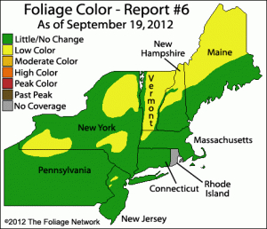
Fall foliage color data, courtesy of The Foliage Network. Image and data valid as of September 19th, 2012.

be no surprise to anyone that the first signs of fall colors are appearing over parts of New England, Southeast New York, and Northern New Jersey. Now, it should be mentioned that these colors can typically take a few weeks to work their way down to the immediate suburbs of New York City, as well as Central New Jersey, Connecticut and Long Island. Yet, one can already observe hints of the impending explosion of natural color in the tips of trees or those exposed to more sun than others on a daily basis. Some will spend the next few weeks longing for one more warm, muggy summer night while others will be teeming with excitement as the colors fill the trees and warn of the impending winter. Our friends at the Foliage Network provide excellent map analysis of the progression of the leaf color and leaf drop through the Northeast United States. Their latest report, pictured in this post from September 19th 2012, shows Low color spreading throughout much of New England and even into the mountains of Northern New Jersey.

All of this is a lot to take in, but there’s even more interest to it! Despite a usually timely start, each season provides different foliage timing and patterns depending on the weather patterns and temperatures. For instance, comparing the report from September 19th 2012 to the report from September 17th, 2011 (just a two day difference) shows that we are way ahead of last years pace at this point. The “Low color” category foliage is hundreds of miles farther south and more widespread throughout New England. As the season gets going, we’ll be sure to keep you updated on the foliage progression!

In addition, we’ve opened a Flickr Group to our readers and subscribers (yes, it’s free) for all to post their fall foliage pictures throughout the season. The group will remain open for the future, as well, hopefully serving as a central point for NYC weather and nature related photography. We can’t wait to see your best photos!

Forecast: Cooler weather on the way behind cold front

Behind a cold front which brought significant winds and severe storms to the area on Tuesday (familiar to the front that came through a few weekends ago), cooler air will make its presence felt in the Northeast US beginning on Wednesday.

NAM-WRF Model showing low temperatures Thursday morning in the 30’s across New England, and upper 40’s to lower 50’s in parts of New Jersey and NYC.

West-northwest winds will help usher in drier air, which will be the biggest difference you’ll feel upon venturing outside during the mid-week. The humid air and gulf moisture which advected into the area on Tuesday ahead of the cold front has been swept out of the area, and the upper level trough approaching the region will bring the cooldown. Temperatures on Wednesday Night into Thursday morning are forecast to drop into the mid to upper 40’s inland, and lower 50’s in the city and urban areas. Across parts of New England, forecast models are hinting at the potential for temperatures to drop into the 30’s under clear skies and light winds!

The cooler air will moderate with time, as we will observe a warming trend in mid-day temperatures by the end of the week. However, it looks like more upper level troughs will progress towards the region (minus the big warm ups and storms ahead of them), likely keeping the weather on the cooler side of normal through the near future.

Wednesday: Cooler, but bright sun returns. Noticeable drop in humidity and much less wind. Still a bit of a breeze out of the northwest. Highs in the mid 70’s.

Thursday: Highs barely scrape into the lower 70’s with cool northwest winds prevailing. A cool start in the morning, too, with temperatures in the upper 40’s to lower 50’s.

Friday: Warmer than the past few days as the airmass begins to modify a bit. Highs in the middle 70’s, warmer in some spots. Light winds.

Severe Weather Threat With Tornadoes Possible Today

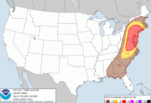
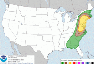
6z SPC Forecast, indicating a 10% tornado probability within 25 miles of a point (top) and a 30% severe wind (58mph gust or higher) probability within 25 miles of a point (bottom).

We have one of the most dynamic storm systems for the month of September in quite some time. The Storm Prediction Center has a “slight” risk of severe thunderstorms for the entire Metro area, but even more impressive is the 10% tornado contour and the 30% severe wind contour. There is also a 5% hail contour, but I would honestly be surprised if there were any hail reports.

We have a potent, amplified longwave trough diving down into the entire eastern half of the country with an associated powerful shortwave moving through the Northern Great Lakes and into Canada. This trough is phasing with ample tropical moisture to the south, helping to create a powerful, dynamic storm system. There will be a warm front moving across the area in the early morning hours, and a powerful cold front moving from west to east, crossing the Metro area in the late evening hours. There are two primary threats with this storm system: discrete low-topped supercells that may form some weak tornadoes, and a squall line entering the region in the late evening hours helping to produce very strong winds. Click “Read More” below to read full-length post. 

Read more