Long Range: High latitude blocking could set off major changes

GFS Model Ensembles 500mb Standard Height Anomalies, showing high latitude blocking from the North Atlantic, through the Davis Straight, and north of the Aleutians.

It has been a while since the meteorological community has been given the chance to analyze some high latitude blocking, at least blocking that looks to have a fighting chance at actually coming to fruition. The last major high latitude blocking event in the fall or winter season came in January-February 2011, and was one of the major causes of an unusually cold and snowy winter in the Eastern US. Since then, many blocking episodes have been modeled too strongly in the medium range, only to appear weak and meager in reality. This time, however, teleconnections support the development of strong blocking not just in the Atlantic, but from north of the Aleutians as well. Medium range ensemble guidance supports positive height anomalies (+3 to +4 Std. Anomaly of height at 500mb) by 72 hours, or the middle of this upcoming week as you can see in our lead image right above this text.

The three major areas of positive height anomalies at 500mb are fairly classic — one from the North Atlantic (which will eventually surge westward towards Greenland), one over Central Canada west of the Davis Straight, and the aforementioned major block with very impressive positive anomalies north of the Aleutians. The three would effectively keep the high latitude well “blocked” through the medium range — something we have only seen in spurts during the past several months.

GFS Ensemble Mean temperature departures on Day 6 (Saturday 10/27/12) showing an outbreak of cold air over the Central US heading east.

With the high latitude blocking development, most if not all of medium range model guidance has -NAO values through the long term with no major rise in the near future. The GEFS mean NAO forecast plume shows values of near -2.0 through the end of the period. You may be asking yourself, after a broad brush of the pattern — despite this, most of the forecast models are showing a ridge in the east and above normal temperatures. So what gives? The answer is a strongly -PNA with the Aleutian/Alaskan ridge correlating well with a big trough over the West Coast by Day 5. The southeast ridge flexes its muscles in the east allowing for positive temperature anomalies to develop. However, in such a pattern…it is only a matter of time before a major shot of cold air is forced southward underneath the blocking into Central Canada and eventually the Central/Eastern US. This will likely come in the form of a large upper air trough by Day 7, easily visible on the GFS temperature departure means to the left.

Keep Reading for a full discussion on the long range, including a cold air surge and potential tropical systems…

Read more

Forecast: Sunday brings pleasant end to weekend

NAM forecast model, showing low temperatures in the 40’s throughout most of the area Sunday Night through Monday morning. Notice the slightly warmer temperatures in NYC and on Long Island.

Another cool and pleasant autumn weekend is coming to a close — but first we have a pleasant Sunday on tap with beautiful mostly clear skies, cool temperatures, low humidity, and of course…football! Temperatures in the 50’s and 60’s are expected today with light west winds that could feel a bit breezy at times. Low humidity will be the main player in keeping things feeling fresh and comfortable, if not a bit chilly. Much of the same is expected through tonight. If you haven’t had a chance to catch the Orionid meteor shower yet, which peaked last night, get out tonight and check a few out before the shower dwindles by tomorrow.

Rest of Sunday: Gorgeous fall day will continue. Sunny, with high temperatures in the low to middle 60’s. Several degrees cooler than Saturday which featured warmer temperatures ahead of a front. But the sun will still be warm — with a light west wind. Get out and enjoy it!

Tonight: Mostly clear with low temperatures falling into the middle 40’s inland and around 50 in the city and metro areas (maybe a few degrees warmer in the usual warm spots). West winds around 10 mph will continue. Definitely bring a sweatshirt if you’re headed out.

Monday: Another gem — not much more to say. High temperatures again the middle 60’s with west winds continuing, mostly light with the occasional breeze.  Winds will shift northwest by the afternoon, but not much change in sensible weather.

Check out the full forecast at a glance in our widget to the right, or head over to the Forecast Brief and Discussion for all the full details on the week ahead. Don’t forget to follow us on Twitter and Facebook for constant updates!


Favorable viewing conditions for annual Orionid meteor shower

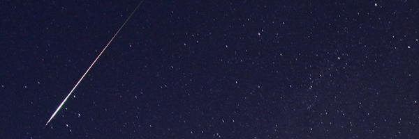
Meteors will streak across the night sky (up to 25 per hour) from Saturday Night October 20th into the morning of October 21st during the annual Orionid meteor shower.

Up to 25 meteors per hour can be viewed this Saturday Night through the pre-dawn hours of Sunday morning as the annual Orionid meteor shower peaks. The Orionid shower results as the remnants of Haley’s comet, and returns each October to bring shooting stars to the night sky. However, each year is different and the viewing conditions can change dramatically. Last year, for instance, featured a very bright full moon which obscured most of the meteors aside from the brightest ones. This year will be a much better viewing year — with a dull moon and plenty of opportunity to view even the more faint meteors which will streak through the sky at the highest rates after midnight on Saturday Night/Sunday morning. The clear skies are expected to provide perfect outdoor viewing conditions as well. It is expected that up to 25 meteors per hour can be viewed with the meteor shower — not the most prolific amount, but decent.

Where are the best spots to view? Anywhere away from the bright lights of New York City. The city lights make it nearly impossible to view any but the brighest, biggest meteors. Head to the suburbs of Long Island, New Jersey, New York, or Connecticut. Even the immediate interior suburbs of Union, Essex, Bergen, Westchester/etc will do. If you’re looking for the most prolific show, head to the mountains of Northwest NJ or the far interior of Southeast New York. If you’re feeling really ambitious, head to New England for even better viewing.

What time is the best to see the most meteors? Any time after sunset on Saturday, technically. But the ideal time is between 11pm on Saturday night and 5am on Sunday morning. Not only will the moon be dull and the skies clear, but the actual meteor shower reaches peak intensity at that exact time. So you’ll be treated to the best show at that time.

We’ll be updating our Twitter account with more information on the meteor rates per hour during the event — and of course, send us your observations and pictures if you have them.

Indian summer this week, but will it continue?

GFS Ensembles showing above normal mid-level height anomalies throughout parts of the Central US during the last week of October. Courtesy Stormvista.

Most of the area has seen the first frost/freeze of the season with the exception of the immediate coast and urban areas (NYC, JFK, LGA, EWR). Any period of warmth / above normal temperatures that occurs after the first freeze is referred to as an “Indian Summer.” We’re certainly see that today – widespread warmth with temperatures surging into the 60s after morning lows in the 30s/40s for many. High temps near 70F in land portions of New Jersey cannot be ruled out today, and tomorrow should feature 70s across the entire metro area out ahead of the next cold front.

Beyond this week, folks are beginning to get antsy for the winter, and some are excited about the prospect of more blocking this winter compared to last winter’s complete lack of any block (Blocking – the tendency for positive height anomalies to form in the northern latitudes which can result in troughiness / cold weather in the middle latitudes).  While it’s true that we have plenty of blocking right now, that doesn’t necessary mean that we’ll see it persist into winter. We’ll have to see how the pattern evolves over the next several weeks.

Moving forward, many forecast models are suggesting a generally mild regime for the Eastern US. Why is that the case given the negative NAO and AO currently in place? Doesn’t a negative NAO mean troughiness / cold in the East? Generally in the winter months that is true, yes, but the correlation between NAO values and height anomalies in the Eastern US is not as strong as other indices, like the PNA, right now.

Keep reading for all of the details, technical discussion, and forecast…

Read more