Forecast: Pleasant weather takes hold of mid-week pattern

Rain and showers were on the way out of the area in the early morning hours on Monday, and by your morning commute things will be clearing out with a new cool airmass in place. Drier air will be advecting in with west/northwest winds during the day. Plenty of sun as well — and the cooler temperatures aloft will translate to the surface with highs only in the lower 60’s in the city and even cooler than that over the interior. Much of the same is expected on Wednesday and Thursday, with temperatures moderating a few degrees each day.

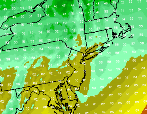
NAM forecast model showing high temperatures in the lower 60’s on Tuesday afternoon.

Tuesday: Awesome fall day – not many other ways to describe it. High temperatures in the lower 60’s throughout Central and Northeast NJ/NYC. A few degrees cooler in the interior spots of NJ/NY/CT. West/northwest winds will prevail during the day and they may be a bit gusty at times. Low humidity and plenty of sun. 10/10.

Tuesday Night: Crisp, cool autumn air in place once again. Mostly clear skies with low temperatures falling into the upper 40’s in the city. Cooler in the usually cold interior spots. The gusty west/northwest winds will lighten a bit. Bring a sweatshirt or jacket if you’re headed out.

Foliage: Fall foliage has progressed rapidly over the past week or so, likely owing to the very cool temperatures and periods of rain throughout the Northeast. Parts of Northern New England are way ahead of the last several years foliage — with past peak colors being observed. Most of Central New England is near peak color, while our area (NJ/CT/NY) is beginning to near peak with Moderate Color.

Tropics: Hurricane Rafael churns in the Atlantic as a late-season storm. He is expected to shift northward over the next few days, missing Bermuda to the east, and then turn north-east into the Northern Atlantic Ocean before dissipating. Rafael is not a threat to the US.

Check out the full forecast through the weekend. Also, if  you haven’t yet, check out our daily posts on Facebook and follow us for live updates and interact with our forecasters on Twitter!


Forecast: Rain returns to dampen Monday

A pleasant weekend will give way to a damp Monday, with rain chances increasing especially during the second half of the day. The culprit will be a low pressure system, developing along a front to the east of our area. The result in terms of sensible weather will be the development of showers with periods of steady rain possible especially along the coast. Forecast models are still struggling somewhat with agreeing on the area of heaviest rainfall relative to New York City, but there seems to be at least some consensus that the bulk of it will remain east of the city over the New Jersey coast and Long Island. In fact, some models show very small rain amounts over the interior areas. Temperatures on Monday will remain warmer with humidity levels still up, with highs in the lower 70’s. Things will change by mid-week behind the system.

NAM forecast model showing a period of moderate rain over parts of the area on Monday afternoon. Graphic shows accumulated rain in the 3 hours before 8pm.

Monday: Partly cloudy with a few showers to start, and warm temperatures will still be in place throughout the area. Steady rain developing during the afternoon, especially NYC and points-east with the storm offshore. Showers continuing through evening before dissipating as a front crosses the area. Winds turn west and temperatures will drop by late-evening. High temperatures will top out in the 70’s during the early afternoon.

Monday Night: Early in the evening, rain will be likely throughout the area especially east of NYC as the storm system passes near our area. Forecast models show best rain chances along the NJ Shore and Long Island/CT. Late overnight/early Tuesday morning…expect gradual clearing with temperatures falling into the 50’s behind the storm system — with west winds continuing. Sweatshirts will be back in play if you’re headed out at any point during the evening hours.

Keep reading for more details on the forecast for the remainder of the week…

Read more

First freeze of autumn is likely in suburbs tonight

A cold front crossing the region today (without any heavy rain or high wind) will usher in the coldest air of the autumn season to date. Although it will only be in the area for a brief period of time, with a warmup beginning by the second half of the weekend, the cold air and clear skies on Friday Night through Saturday morning will allow temperatures to fall near 32 degrees or lower across much of the interior of New Jersey, Southeast New York, and Connecticut. Near-freezing temperatures could also reach some major cities such as Trenton and Newark, but a freeze is not forecast there. New York City could observe temperatures falling to the 40’s or possibly upper 30’s in isolated locations. The expected freeze is not wildly out of place or unheard of for this time of year. In fact, areas in Pennsylvania are a few days behind their average first freeze. New York City historically experiences it’s first freeze between the end of October into November, while interior areas of NJ/NY/CT experience it in mid-October.

NAM model showing low temperatures in the 20’s and 30’s over inland areas, with 30’s and 40’s in the city from Friday Night into Saturday morning.

Rest of Today/YanksCast ALDS Game 5: The Yankees play a decisive Game 5 of the ALDS against the Baltimore Orioles in the Bronx today at 500pm. Partly cloudy skies, west winds, and temperatures in the 50’s are expected. For the rest of the area, a cold front will cross the area this afternoon. So temperatures could spike into the mid/upper 50’s before dropping behind the front.

Tonight: The coldest night of the season so far, throughout the entire area. Interior locations will see light west/northwest winds and clear skies with temperatures falling into the 20’s and 30’s. Freeze Warnings are in effect for the suburbs of NJ/NY/CT. In the city, warmer temperatures but still in the upper 30’s to near 40. The usual cold spots on Long Island will see temperatures bottom out in the 30’s as well.

Saturday: Partly cloudy and cool with temperatures topping out in the 50’s behind the front. A warm front is already creeping up on us by the late afternoon over the Ohio Valley, so we could begin to see some clouds streaming in ahead of it. Winds will start out northwest but turn south by the afternoon.

If you haven’t yet, check out our daily posts on Facebook and follow us for live updates and interact with our forecasters on Twitter!
Finally! Pleasant weather arrives to end the week

The unsettled weather which has been in place throughout our area over the next several days will finally lighten it’s grip on the weather pattern on Thursday. The even better news is that the fair weather, with a lack of precipitation and clouds, will last through the weekend. In addition, and quite possibly the weather story of the weekend, a cold front crossing the area on Friday will usher in a brief (but very cool) Canadian airmass which looks to bring a legitimate freeze to many interior areas. Some forecast models show the metro area dropping into the 30’s as well. Beyond the cold air Friday Night/Saturday Morning, warm air will rapidly re-enter the area with temperatures warming up into the upper 60’s to near 70 for highs by Sunday.

NAM Model showing low temperatures falling into the 20’s and 30’s throughout the area on Friday Night/Saturday morning.

Thursday: The sun will shine for the majority of the day with high temperatures near 60 or in the low 60’s. Northwest winds will turn west during the day.

Thursday Night/YanksCast ALDS Game 4: Another cool October night is on tap with the Yankees trying to finish off the Orioles in the Bronx, heading into the game up 2-1 in a best of 5 series. West winds and clear skies will bring overnight lows to a very cool low to mid 40’s in the city and 30’s inland.

Friday: Another partly cloudy day (we can get used to this, right?) with temperatures near 60 to start. But things will quickly cool off behind a front that passes in the afternoon. Winds will kick up from the west-northwest and temperatures will plummet Friday Night. In fact, the first freeze of the year now looks like Friday Night into Saturday morning with low temperatures dropping into the 20’s (yes, 20’s) inland and 30’s near the city (probably upper 30’s in the urban areas of the city).

Look ahead to the weekend: Cool and sunny on Saturday with highs in the 50’s. Warm front crosses the area Sunday morning– and winds turn south/southwest. Temperatures will respond fast with highs potentially approaching 60’s and near 70 on Sunday. Warmer weather looks likely by early next week.

If you haven’t yet, check out our daily posts on Facebook and follow us for live updates and interact with our forecasters on Twitter!