Afternoon Update: Raw, dreary Sunday continues

A coastal low pressure area, developing to our south and east along the cold front which passed our area on Saturday, has aided in the development of light to moderate rain and widespread showers throughout the area on this Sunday afternoon. In addition, the cool airmass combined with the clouds and rain is keeping temperatures in the 5’s (and even 40’s in some areas) with high temperatures only expected to touch into the mid 50’s in the warmest locations this afternoon. Later this evening, things will likely become even more raw as temperatures begin to fall and rain blossoms over the area in response to the surface low moving east off the Mid-Atlantic Coast and strengthening a bit. The rain is expected to continue through around midnight, before tapering off. Not all is clear behind this system, though, as after a break on Monday it appears showers will return to the forecast on Tuesday and Wednesday.

Latest NYC-Area radar imagery courtesy of weather-underground shows the intensity and movement of precipitation over the last hour.

Rest of Today/Tonight/Yanks Cast Game 1: Showers likely, temperatures in the 50’s throughout the day. Falling temperatures by early evening with showers continuing through around midnight. Showers are expected to taper off after midnight as the storm begins to move northeast of the area. Temperatures remaining chilly. Yankees play ALDS Game 1 in Baltimore. Showers are likely there as well, ending around 8pm. The game should be played, but under very poor conditions.

Monday: Partly cloudy with a break between atmospheric disturbances. Temperatures running a little warmer than Sunday, into the lower to possibly mid 60’s in isolated locations. Clouds increase by evening with another system approaching from the south and west. Showers will begin over southern areas by mid-evening.

Monday Night: Showers likely as a low pressure system passes offshore. Another raw evening with temperatures in the 40’s and 50’s and northeast winds around 10 miles per hour. Rain could be steady/moderate for a period of time, especially near the coast. Sweatshirt weather to say the very least — umbrellas are a good idea as well.

Tuesday: Starts off poor with showers, clouds, and raw weather once again. The system begins to pull away by afternoon, however, so although scattered showers could continue the general weather will improve. Could see a late-day high near 60 in some isolated locations, but it will generally remain in the 50’s once again. Yankees play ALDS Game 2 in Baltimore (hopefully up in the series 1-0 by this point). Scattered showers, but the system affecting our area will be off to the Northeast of Baltimore by game time. Expect this game to be played without many issues.

Forecast: Cold front will bring big weather change

Warm, humid, uncomfortable. Those three words are just a few that accurately describe the air that has been in place throughout the area over the last several days — and although some have enjoyed it, the lack of sunshine has kept things more dreary and uncomfortable than summery and hot. It is safe to say, in fact, that if the sun had come out for more extended periods of time, temperatures would have soared into the lower to possibly even middle 80’s in this airmass. However, it was not to be…as the moist tropical air brought plenty of clouds and instability with it. Still, some enjoyed what looks to be the last taste of late-summer air over the end of last week into this weekend. Now, as we approach the middle point of the weekend, a cold front is right on our doorstep — and it will bring a dramatic weather change. No showers or strong thunderstorms are expected, but the temperature drop over the next several hours will be fairly dramatic with some areas falling from the upper 70’s and low 80’s into the 40’s and 50’s by this evening. Winds will shift quickly from the south/southwest to the west/northwest in the wake of the cold front. And, with its passage, will come a new autumn airmass with much less humidity. That being said, things will remain unsettled before the crisp, sunny autumn days can arrive. A low pressure area on a cold front will provide showers and rain with raw and chilly temperatures on Sunday. Check out the details below.

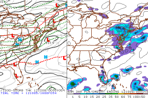
NAM Model showing low pressure offshore causing periods of rain in the area on Sunday.

Rest of Today: Cooling off throughout the afternoon as a front passes the area from west to east. Wind shift from south to west with the frontal passage. Temperatures topping out in the upper 70’s very early in the afternoon, falling into the 40’s and 50’s by early evening.You may be more comfortable in jeans by around dinner time, if you were wearing shorts/tshirts/etc this morning as a result of the warm air.

Tonight: Winds from the west behind the front, and clearing skies. Temperatures will fall into the 40’s inland and in the 50’s in the warm spots. Some isolated interior locations could bottom out in the upper 30’s. Much, much cooler than the past several nights. It will be very noticeable.

Sunday/ALDS Game 1 Forecast: Sunday may start off decent, with temperatures very cool and some clouds beginning to work back into the area. By the mid to late afternoon, showers and periods of steady rain will begin working into the area from the southwest. The culprit? And area of low pressure riding along the cold front to our east (yes, the one that passed us on Saturday). The rain will continue through Sunday Night with temperatures in the 40’s and 50’s (yikes). The ALDS Game 1 in Baltimore looks to have some issues — at the very least, cool and raw temperatures with showers likely (more than 50%) at some point during the game. It will be interesting to see if they play the game through the rain, or opt to push it back and delay the series by a day as a result. Either way, Go Yankees.

If you haven’t yet, check out our daily posts on Facebook and follow us for live updates and interact with our forecasters on Twitter!


Forecast: Warm air hangs around, big change looms

Despite afternoon showers and thunderstorms which impacted the area on Wednesday, warm and humid air remained in place throughout the region. The surface cold front, lagging well back to the west over the Ohio Valley, isn’t expected to cross the area until Saturday afternoon. As a result, the warm and humid air will remain in place for a few more days … for Friday and part of Saturday. High temperatures on both days are expected to reach into the upper 70’s and could exceed 80 degrees in some locations. These types of temperatures are not incredibly rare in October, but are definitely above normal for this time of year. The humidity certainly isn’t helping, giving the air more of an August-like feel than the usual Autumn air which is in place over our area during October. However, fall lovers, fear not! The strong cold front mentioned earlier is on its way, and will bring some of the coolest air of the season into the Northeast US with it. The one caveat to the scenario could be a wave of low pressure which some forecast models show riding along the cold front to our east. This would bring a cold, raw rain to the area on Sunday with temperatures in the 40’s and 50’s. We’ll have to keep a close eye on it for a potential weekend spoiler — and impact on the Yankees in the ALDS (if it is played in Baltimore for Game 1, Texas would have no weather issues). Stay tuned!

NAM Model showing a cold front approaching the area on Saturday. Notice the big drop in temperatures behind the front over Pennsylvania.

Friday: Partly cloudy, but the main story will be the continuation of above normal temperatures with warmth and humidity. Cold front still lagging back to our west. Uncomfortable air, still — too warm for long sleeves. Temperatures in the upper 70’s to near 80 in some spots. Isolated showers should be less prevalent than they were on Tuesday.

Friday Night: Partly cloudy once again, and warm once again. Isolated fog. Temperatures staying in the upper 50’s to middle 60’s in the warmer spots.

Saturday: Very warm and partly cloudy to start, with temperatures in the mid 70’s and rising into the lower 80’s by early afternoon. A cold front quickly approaching from the West will bring an increase in clouds and a chance of showers and thunderstorms. Winds will shift quickly west behind the front and temperatures/humidity will drop.

Saturday Night: West winds and eventually clearing skies will be the first signs of a new airmass entering the area. Cooler air will be in place as well — so temperatures will drop into the 40’s and 50’s throughout the area overnight. Should feel very refreshing compared to the warm and humid airmass of prior days.

If you haven’t yet, check out our daily posts on Facebook and follow us for live updates and interact with our forecasters on Twitter!

Wednesday Forecast: Milder air pushes north

Autumn like weather, including a variety of days featuring cool and brisk temperatures as well as (most recently) damp and raw conditions with rain, has generally been in place throughout the area over the past few weeks. However, Wednesday and Thursday will bring a bit of a reversal towards a more late-summer like pattern, with temperatures increasing into the upper 70’s and humidity rising once again. The culprit? A ridge in the Western Atlantic which is building back west towards the East Coast during the middle of this week. You can blame the clouds and showers on a gradient between that ridge, and a trough off to our west. A strong cold front eventually looms for late this week, which will bring the autumn weather back into the picture (and perhaps well-below normal temperature departures next week). But until then, temperatures averaging above normal..and generally more humid and warm conditions are expected on Wednesday and Thursday. It won’t be a full-fledged summer-like day, though, that’s for sure. Fog and clouds should hang around early on Wednesday to keep temperatures low to start, before they rebound a bit in the afternoon with a chance of showers and storms. Much of the same is possible on Thursday.

Latest Temperatures through the Mid-Atlantic and Northeast courtesy of Rutgers Weather Net. Click to enlarge.

Today (Wednesday): Warmer with high temperatures in the upper 70′s to possibly 80 in some locations by afternoon. Scattered showers and isolated thunderstorms are expected to develop in the late afternoon and continue through the early evening before tapering off with the loss of daytime heating. South winds throughout the day — again, the biggest story will be the warmth and increasing humidity and dew points. Fog and clouds early in the day, we could see some breaks in the clouds by afternoon.

Wednesday Night: Mostly cloudy with a chance of showers continuing through the night. Much warmer with low temperatures in the 60’s throughout most of the area. A bit cooler inland — and a bit warmer in the city. Showers should mostly be isolated to scattered.

Thursday: Warm once again, with high temperatures in the upper 70’s to near 80 in some locations. Clouds are forecast on most models — but there should be some breaks during the day. We’re again looking at a chance of isolated showers during the afternoon hours. However, not a wash out by any means — so enjoy the warm temperatures before they’re gone!