Forecast: Seasonable, dry weather holds until weekend

NAM model showing cloudiness around the area on Tuesday afternoon. Notice the low clouds (solid grey) near the coast, and mid/high clouds (light/dashed) inland.

A stretch of dry and pleasant weather has continued into the early part of this week, and the seasonable and dry trend will continue through the middle and end of it as a high pressure remains in control. The pattern looks to change in the long range, but for now it will remain seasonable as a low pressure system passes well offshore to our east. The system will provide periods of clouds from Tuesday through Thursday, however, as a northeasterly flow around the system offshore brings in some marine air, especially along the coast. Temperatures, which have been running 5 degrees or more below average for the month, will remain slightly below normal to near normal during the week. The next chance for precipitation looks to come at the end of the week into the weekend, when a cold frontal system will sweep through the Northeast. Some snow or rain squalls/showers are possible with this passage – which will bring in a very cold airmass.

Tuesday: Partly sunny with highs in the lower 50’s, a bit cooler away from the coast and city. High and mid level clouds will be around beginning in the late morning and afternoon, so we may not see much full sun — but some of these could burn off at times. Northeast winds around 10 miles per hour.

Tuesday Night: Mostly cloudy with temperatures falling into the 30’s and 40’s and northeast winds continuing.

Wednesday: Partly sunny with highs a few degrees warmer, in the low to mid 50’s. Northeast winds continuing but less clouds than Tuesday and Tuesday Night.

Looking Ahead: Models are keying in on some low clouds and fog developing Wednesday Night into Thursday, so it could be pretty gloomy to start the day. This should burn off by afternoon but may have some trouble doing so given the persistent northeast winds and marine air. Beyond this, some clearing for Friday and then a cold front passes this weekend bringing a chance of rain/snow showers and much colder air by early next week.

Colder, active pattern looks likely to open meteorological winter

Although many of us have already seen a significant snowfall on November 7th, we are getting closer to December — the start of meteorological winter — so many of you must be wondering when to expect more snow. I can’t tell you that specifically, but a detailed model analysis may point to a relatively favorable scenario for snow lovers come the first half of December.

Last November and December, there was no high latitude blocking or ridging, which bottled up all of the cold in Alaska and the Poles, and there was no cold air source in Central and Southern Canada. However, there are signs of a strong developing cold air source in Canada, which is one of many steps that need to be taken in order to generate a snowy pattern. How does this cold air source result and will there be any mechanisms to bring that cold air down to the eastern half of the United States?

An anomaly composite from last November and December shows a lack of any high latitude blocking and ridging, which kept the cold air bottled up in the Arctic. This resulted in a very warm pattern for the Continental US.

A below normal temperature pattern has been settled into much of the Northeast United States since the start of November, but aside from the early-month Nor’easter things have remained relatively calm and dry. This time of year is always interesting, meteorologically, as the pattern undergoes tremendous changes as winter starts to take hold. Lower heights, stronger systems, and colder air start getting involved — and forecasters start looking ahead to the winter. Last year at this time, forecasters were staring at data which pointed at an unusually warm start to winter that would continue through at least New Years. Some of which included low snow and ice cover and a lack of any high latitude blocking. The composite image shown to the right illustrates this quite well; there was nothing favorable last year for cold and snow.

This year, we are seeing the emergence of the polar (no pun intended) opposite pattern. Forecast models and long range data are pointing to the development of several key features which will set off a sequence of events that, historically, lead to colder and more active patterns in our area. We’ll take a look at what the data is showing below:

GFS height anomalies at 500mb (mid levels of the atmosphere) showing the anomalous ridge over the Aleutians and Northwest Alaska.

A Strong Aleutian Ridge: This feature may be the most underrated signal for pattern changes in the Northern 1/3 of the US. A strong ridge over the Aleutians and into Alaska can successfully dislodge cold air from Northern Canada and the poles into Central Canada and even the Northern 1/3 of the United States. With snow cover already above normal in that area this time of year, this development becomes very important. More cold air and below normal height anomalies for a few weeks over that area will set the stage for the presence of cold air to our north to start the meteorological winter. Additionally, forecast guidance has this feature developing into an anomaly — and a dominant one at that. +2.0 to +3.0 standard anomaly of heights throughout much of the Aleutians into Western Alaska is a common theme on mid range model guidance and ensembles. Even more interesting, down the road, is the potential impact this anomalous feature could have on the pattern. We don’t have to look far to find the last time one of these Aleutian Ridges popped up — and we can also find a familiar theme on the developments it sets off on the model guidance today.


Read more

Forecast: Cool, pleasant weather underneath high pressure

GFS forecast model showing a high pressure system dominating the weather pattern over the Northeast US through the end of the weekend, with little chance for precipitation.

Stormy and unsettled weather haD become a fact of life in our area over the past few weeks, but the changed weather pattern will bring a much needed respite in activity through the end of the week and this weekend. A dome of high pressure building in over the Eastern US and a fast, progressive pattern in the mid levels of the atmosphere will keep the storminess away for the foreseeable future. Seasonable temperatures are also expected through the weekend, with overnight lows dropping into the 20’s and 30’s inland (warmer near the coast) and daytime highs scraping into the 50’s. No precipitation is expected through this weekend either, with plenty of sun to go around. A free and easy forecast.

Thursday: Partly cloudy, cool, but plenty of sun. High temperatures in the upper 40’s and low 50’s throughout the area. North/northeast winds around 5 to 10 miles per hour.

Thursday Night: Partly cloudy, cool. Lows in the upper 20’s inland, mid 30’s in the city and near the coast. North winds continue.

Friday: Mostly sunny once again, a bit warmer than the past few days with highs into the lower 50’s (slightly warmer in some locations). North winds continue, though, around 10 mph.

Saturday: Mostly sunny once again, with high temperatures again reaching into the low to mid 50’s. Much of the same as Friday — with no precipitation expected and just a few clouds.

Looking Ahead: Forecast models have trended weaker and farther out to sea with a potential storm system early next week. The progressive mid level pattern is expected to keep things moving — and not allow the storm to crawl up the coast. We’ll keep a close eye on it, but for now it looks like more dry conditions are expected through early next week with just a chance of some more clouds and unsettled seas with a northeast wind if the storm gets close enough to the area.

Recapping the last two weeks of historic weather

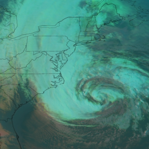
Hurricane Sandy, as she churned up the eastern seaboard on October 28th, 2012.

Often times, especially in the field of meteorology, things can be exaggerated. This becomes especially true when you’re talking about the atmosphere and mid latitude storms — a fluid and dynamic process where some of the most beautiful (and sometimes destructive) systems on earth can form. Your friends, parents, or even grandparents will tell you of the old winters back in the 40’s and 50’s that they lived through which featured 90 inches of snowpack and 150 foot snow drifts. A colleague will detail an awesome thunderstorm which produced beachball sized hail. Or maybe you, yourself, experience a weather event so thrilling that in your words, you exaggerate it a bit to your friends. All of that said, every once and a while, a certain weather event — or a period of time, emerges that cannot possibly be exaggerated. The last two weeks, which we just lived through, is one of them.

As meteorologists, our job is to forecast the weather and inform the public of what the forecast is and how to prepare adequately. It’s a delicate process. Yet, on some days, the process becomes even more delicate than usual. This was the case in during our forecast operations on the afternoon of October 25th, 2012 — just a few days before Hurricane Sandy. Earlier in the week, we had warned of the impending threat in a blog post which read

What catches the long range forecasters eye around Day 5-7 is the forecast development of a tropical system in the Caribbean, which could drift north into the Southeast Atlantic by Day 7. Such a development doesn’t seem overly concerning at first — but the mid and upper air pattern rings some serious alarms for long range forecasters almost immediately. Although variance at this range is a major factor — forecast models don’t usually get a good grip on the pattern for several more cycles — the blocking adds an extra level of intrigue to the pattern development. Should the tropical system head north and not east (also a big question mark) it could be drawn into a phase with the large upper level trough and aforementioned cold front over the Eastern US.

Yet, even with advanced warning, forecasting a storm like Hurricane Sandy is a difficult process. On that afternoon, we were in touch with a significant emergency management corporation. And for the first time as an organization, we told them “this is not a joke. this is a life threatening situation.” This wasn’t a summertime thunderstorm. There were lives at stake — and our forecasts, conferences, and abilities to communicate to our readers could ultimately save lives.

Read more