Slight risk for strong storms this evening

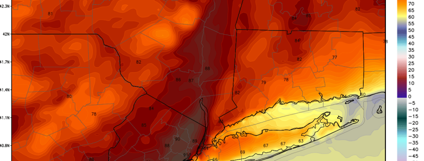
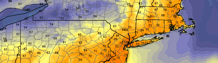
The Storm Prediction Center has placed much of the area from New York City westward in a Slight Risk for severe thunderstorms this afternoon and evening. Ahead of an approaching frontal boundary, warm and humid air is advecting northward into the region. Increasing dew points and surface heating will lead to the development of moderate instability throughout the area by the afternoon hours. Accordingly, the approaching front will aid in the development of storms from Eastern Pennsylvania into Western New Jersey.

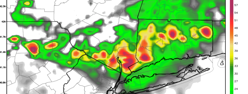
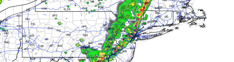
These storms will move toward a narrow axis of instability over New Jersey reaching toward New York City this afternoon. Narrow, only because east of New York City a stout marine layer will remain in place. This will keep storms elevated and weaker — temperatures there will be cooler as well with less instability. Nevertheless, the storms will march eastward through New Jersey toward NYC right around the PM Commute. The main threats with any storms will be gusty winds, lightning, and heavy rain.

This post will be updated throughout the day with the latest information including watches and warnings.

Read more

Warmth and humidity could trigger some thunderstorms Wednesday and Thursday

We hope everyone enjoyed their Memorial Day weekend! Our weather transitioned from average temperatures and dry weather to warmth and humidity as a ridge built in. This weather is expected to persist for most of the rest of the week. However, a few shortwaves of energy may ride over the top of the ridge, which may drag a weak cold front near the area on Thursday. Considering the warm and humid airmass that is already in place, those triggers could be just enough to lead to some thunderstorms on Wednesday and Thursday, but particularly on Thursday.

In the meantime, the core of the ridge is on top of the area, with no ripples of energy to be found. This has led to mostly sunny skies, and warmth and humidity to spread into the region from the Gulf of Mexico. However, the core of the ridge can also lead to the seabreeze circulation cranking, which has kept coastal areas in the 70s. Inland areas are well into the 80s with even some 90-degree readings  in some locations. Newark, NJ has hit a high of 91 degrees.

The area being in the core of the ridge and the seabreeze being able to eventually penetrate quite far inland should lead to enough sinking motion and stability to mitigate any thunderstorm threat this evening. It should be a nice late afternoon and evening, though some persistent breezy weather will continue.

The big ridge will move a bit to the east tomorrow, which may give the atmosphere a bit more room to trigger some thunderstorms.

Read more

Cool, damp weather will lead into a warmer weekend

A developing coastal storm will keep the weather cooler and more damp today, as Thursday will become the “stinker” of the week so far. Clouds and showers moving toward the area are the initial developmental signs of a coastal storm, which will luckily develop well offshore. But cooler northeast winds and clouds will keep temperatures in the 50’s and 60’s on Thursday. As the storm develops, sinking air in our area will kill the development of showers and bring steadier rain closer to the coastal storm offshore, allowing for some clearing by Thursday evening and a better weather day on Friday.

The long-awaited Memorial Day weekend, luckily, looks to feature improved weather over what we will have experienced on Thursday. Westerly winds will begin to usher in a much warmer airmass for the weekend — initially on Friday featuring temperatures in the mid to upper 70’s. A weak frontal boundary approaching the area Friday afternoon will touch off some showers and thunderstorms, but they won’t be a harbinger of anything bad to come. Saturday and Sunday both look to feature pleasant, seasonable weather which will warm each day.

Read more

Weekend Outlook: Warm, humid, scattered thunderstorms

Happy Friday! This week has closed out with some gorgeous spring-weather, with seasonable temperatures and a nice, light breeze. Additionally, after a humid start to the week, the second half of the week has featured very dry conditions.

As we head into tonight and tomorrow morning, clouds and humidity will gradually increase with the presence of a warm front. Before that, however, the rest of today looks quite nice with temperatures generally in the low 70s and partly cloudy skies. There will be an increased breeze along coastal areas as high pressure slides offshore and helps winds shift to southerly. These southerly winds will flow with the seabreeze, which adds to the overall wind speed in seabreeze-prone areas.

This evening will remain pleasant, though high clouds will gradually increase ahead of the warm front. The warm front will be moving in from the west and has plenty of Gulf of Mexico moisture on its warm side. While the front will cross the region at around midnight, there are some signs that it might get held up a bit by the residual high pressure system. As a result, model guidance is not forecasting a true increase in dewpoints until around 4-5:00am. Thus, we are holding off on mentioning showers until 3-5:00am or so. Temperatures will fall into the upper 50s, but may rise to the low 60s by daybreak.

Read more