Meteorological winter is just one day away, and while snow lovers are beginning to get excited, much of the meteorological community is aware that the coming weeks are not likely to offer many wintry precipitation prospects. Our long range outlook will discuss the meteorological pattern for the upcoming 30 to 45 days. With an in depth look into meteorological patterns and the developing global circulations, we’ll explain the processes occuring that will drive our weather pattern through the month of December.
https://www.nymetroweather.com/wp-content/uploads/2015/11/longrange.png294868Miguel Pierrehttps://www.nymetroweather.com/wp-content/uploads/2024/02/Empire-2000-x-300-px-2.pngMiguel Pierre2015-11-30 11:04:132015-12-07 21:53:59Long Range Outlook: Active Pattern in December. But Will it Snow?
The week will begin, to the disappointment of many, with colder weather behind a front which shifted through the area on Sunday morning. The anomalously warm, and almost spring-like, airmass which settled into the area during the latter half of last week and this weekend will have been shunted southward. Behind the front will come cooler, less humid air. Monday morning is likely to be quite crisp, with low temperatures in the 20’s and 30’s away from the coast and in the mid 30’s even in the city.
The week will be marked by a transitional weather pattern, beginning with cold air and ending with a gradual warming trend. In between, periods of rain and unsettled weather are expected during the middle part of the week. A low pressure system moving through the Mississippi Valley and eventually reforming off the East Coast will be to blame, with increasing moisture and lift for precipitation by Tuesday and Wednesday.
Just about a month ago, we released our 2015-2016 Winter Forecast to the public. The forecast featured a tremendous amount of information, research, and data, most of it very technical in nature. With winter only a few weeks away, there is no better time than now for us to lay out the ideas we gathered in a more simplistic form. After all of our work to compile the forecast, there are five general things you should expect during this upcoming winter season.
1) The Winter of 2015-2016 will start off warm
Over the past few weeks, much has been made in regards to the warm pattern setting up for the month of December. Truth be told, confidence has never been higher that December will be a warmer than normal month with less snow than normal as well. Much of this can be attributed to the development and effects of a strong El Nino in the Equatorial Pacific. But some, also, has to do with the surrounding global circulations.
This month, the stratospheric polar vortex (way up there) tightened and strengthened over the North Pole. While this doesn’t totally eliminate any chance for our area to experience cold air, it does make it more difficult. A tighter and more consolidated stratospheric polar vortex means less atmospheric disruption in that region; i.e: Less high latitude blocking, or ridges, to displace the cold air farther south. This vortex is expected to weaken over the next 30 to 50 days, eventually moving and/or splitting and promoting high latitude blocking during the second half of the winter.
https://www.nymetroweather.com/wp-content/uploads/2015/11/nycwinterheader.png281917John Homenukhttps://www.nymetroweather.com/wp-content/uploads/2024/02/Empire-2000-x-300-px-2.pngJohn Homenuk2015-11-28 13:08:152015-11-28 13:08:15Five things to expect during the upcoming winter
Welcome to our long-range outlook for the next 30-45 days. We hope to provide these outlooks with more in-depth analysis and discussion about every Monday and Thursday. The discussion is divided into several topics to cover all aspects of the model guidance and climate indicators.
For today, we discuss the overall pattern and what to expect going into late November and through much of December.
1. Model Guidance Discussion
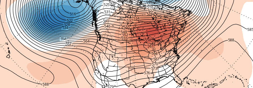
The 500mb pattern this week will feature a North Atlantic ridge being suppressed by a deep polar vortex developing over Greenland and Iceland. This is a classic +AO/NAO pattern that typically supports a strong ridge for the East Coast. A -EPO ridge forming over the the Northeast Pacific and Alaska will cause a trough to dig into the Western US. In response, a ridge will build over the Central and Eastern US.
https://www.nymetroweather.com/wp-content/uploads/2015/11/gfs-ens_z500a_namer_65.png6221024Miguel Pierrehttps://www.nymetroweather.com/wp-content/uploads/2024/02/Empire-2000-x-300-px-2.pngMiguel Pierre2015-11-23 19:48:132015-12-07 22:04:28Long-Range Outlook: Late November and December; December 1 Storm Threat
Hi friends! Our website uses cookies to provide an optimal browsing experience for you. New "Cookie Consent" laws mandate us to inform you of this. As long as you're cool with it, just hit OK. You'll only see this message once.
We may request cookies to be set on your device. We use cookies to let us know when you visit our websites, how you interact with us, to enrich your user experience, and to customize your relationship with our website.
Click on the different category headings to find out more. You can also change some of your preferences. Note that blocking some types of cookies may impact your experience on our websites and the services we are able to offer.
Essential Website Cookies
These cookies are strictly necessary to provide you with services available through our website and to use some of its features.
Because these cookies are strictly necessary to deliver the website, refusing them will have impact how our site functions. You always can block or delete cookies by changing your browser settings and force blocking all cookies on this website. But this will always prompt you to accept/refuse cookies when revisiting our site.
We fully respect if you want to refuse cookies but to avoid asking you again and again kindly allow us to store a cookie for that. You are free to opt out any time or opt in for other cookies to get a better experience. If you refuse cookies we will remove all set cookies in our domain.
We provide you with a list of stored cookies on your computer in our domain so you can check what we stored. Due to security reasons we are not able to show or modify cookies from other domains. You can check these in your browser security settings.
Other external services
We also use different external services like Google Webfonts, Google Maps, and external Video providers. Since these providers may collect personal data like your IP address we allow you to block them here. Please be aware that this might heavily reduce the functionality and appearance of our site. Changes will take effect once you reload the page.
-2")