Weekly outlook: Warmth, thunderstorms, and more warmth

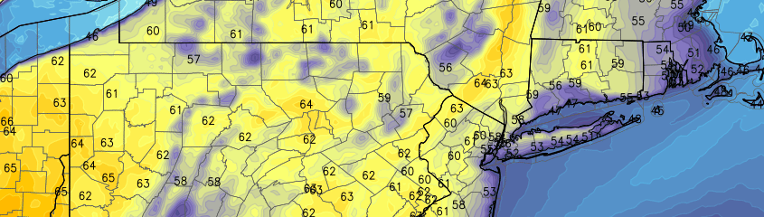
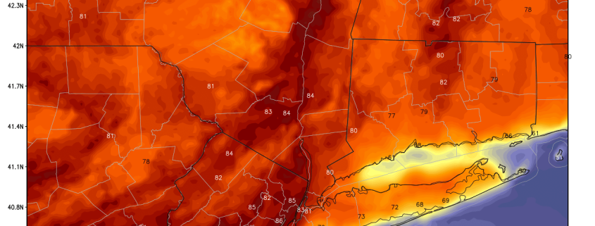
The well-advertised warmup we previously wrote about has finally arrived, and it’s packed quite the punch. Away from the immediate coast, temperatures have hit 80 degrees on consecutive days (yesterday and today), and if clouds don’t increase too quickly tomorrow, we could make it a 3rd straight day.

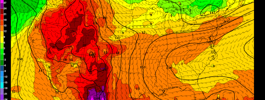
The average high in Central Park on May 4th is 67 degrees. So far today, we’ve already hit a high of 85 degrees. It’s definitely an early preview of summer, as a deep southwest flow has taken over the weather pattern, stemming from a large ridge of high pressure dominating most of the country — particularly the Southeast States and streaming through into our area. A large area of high pressure to our south is the most efficient way to generate warmth, as the counterclockwise flow around the high pumps up the warmth from the Gulf.

With the core of the ridge being near our area and frontal boundaries being well to the north, skies have remained mostly sunny, except for a few cumulus clouds here and there due to the heating of the ground. This will remain the case through the rest of the afternoon, as temperatures generally hold in the low 80s and falling to the 60s and 70s this evening. Areas closer to the coast have had to deal with a sea breeze, as temperatures have held in the 60s and 70s, and will fall into the upper 50s and low 60s this evening. This will also be a general theme during this warm stretch.

While there are initially decent atmospheric conditions for radiational cooling this evening/tonight, an increase in clouds and the warm airmass should keep low temperatures in the mid 50s for the most part — with low 60s in Urban areas.

Moving towards tomorrow, more clouds and a few scattered thunderstorms is a possibility.

Read more

PM Update: Slightly cool, but pleasant evening

Behind a backdoor cold front, which pushed through the area on Wednesday evening, temperatures stayed cooler on Thursday. A cool, onshore flow can be thanked for that. Luckily, most of the clouds which plagued the area during the early part of the day will move out during the later evening and overnight hours of Thursday, so a generally pleasant evening is expected. Any scattered shower and thunderstorm activity will remain off to our southwest, in the Mid Atlantic States.

Temperatures, however, will stay cool and the onshore flow will continue pushing marine air into the area. This is often a relentless characteristic of Spring in these parts, but it doesn’t make it feel any less chilly! Temperatures will fall into the 40’s overnight Thursday into Friday morning, with east/southeast winds continuing through Friday.

Read more

Growing signal for extended period of warmth starting next week

The grass is finally green, the trees are finally blooming, and Spring is finally here. Today is shaping up to perhaps be the nicest day of the year, with temperatures in the mid 70s with mostly sunny skies. Still, though, we have yet to have more than a couple of days in a row of truly spring-like weather, and one of the main reasons that April has been above average in temperatures is because of warm overnight lows, rather than a truly warm stretch of afternoon highs. Fortunately, this is about to change.

Before that, we’re going to have a 3-day period of somewhat chillier weather on Thursday through Saturday, as a coastal storm passes by and brings us onshore flow. However, this storm is expected to stay far enough away from us to avoid any direct impacts, other than increased clouds, a few scattered showers in an otherwise dry and partly sunny regime, and chillier temperatures.

After this storm departs, a building ridge across most of the US will finally press its way northeastward into our area, starting on Sunday.

Read more

Pleasant midweek weather takes hold

After several days of unsettled conditions, pleasant weather will take hold once again during the middle part of the work week. High temperatures which reached barely into the lower 60’s on Monday will moderate a bit on Tuesday, with high pressure remaining in control. Warming temperatures in the mid levels of the atmosphere, partly cloudy skies and light northwest winds will mean temperatures rising into the mid to upper 60’s in many locations. As always, it will be a bit cooler near the coast. But the light offshore winds will keep any major seabreeze or marine impact at bay (no pun intended) for the time being.

Wednesday looks warmer than its predecessor, with further airmass modification and warmer air aloft. Highs may approach the 70 degree mark in the usual warm spots — and light winds with partly cloudy skies will keep it feeling warm and pleasant for the majority of the day. The same may be true for most of Thursday, although increasing clouds late in the day will be a harbinger of things to come as a large and energetic upper level trough begins to dive southward from Canada into the Great Lakes and Ohio Valley late in the day.

Read more