This is not the news many were hoping to hear this morning. Unfortunately, it’s the news we have to provide as a result of medium and long term forecast modeling and the overall hemispheric evolution over the next two weeks. Luckily for those who enjoy the warmth, today looks to be the winner of the week. Behind a mid level atmospheric disturbance which provided the area with rain on Tuesday, warm mid level temperatures will remain in the area on Wednesday. Periods of sunshine and west winds will allow temperatures to rise into the mid to upper 50’s throughout the area. Some areas will approach and may even exceed 60 degrees during the afternoon. Others, especially near the shore, will remain slightly cooler.
The warmth, as is often the case this time of year, won’t last long. Colder mid and upper level temperatures will push southward on Thursday and Friday and temperatures will move back toward more normal levels. The transient pattern will continue through the weekend as another disturbance approaches — bringing precipitation mainly in the form of rain, as temperatures briefly warm up once again before crashing back down on Sunday. Still, that will be just the beginning of the trend toward a colder, more active pattern which will establish itself in the medium to long range.
I enjoy data. New York City’s weather station has been keeping data records for 152 years. Yes, that’s right, observers have been collecting weather data in New York City since 1863. That, my friends, is a long time ago. Since then, there have been an innumerable amount of impressive weather events. Hurricanes, winter storms, severe weather, flooding, heat, cold. New York City’s geographic location features an incredible amount of variability and extreme differences based on location. These simple facts, as straightforward as they are, make this winter — especially from February through early March — all the more impressive.
When looking at this winter as a retrospective, although it isn’t yet over, one can easily become caught up in statistics and information. This February through March in New York City will go down in the record books as one of the more impressive and extreme winter weather periods. For both cold and snow, the past 60 days have been historic.
https://www.nymetroweather.com/wp-content/uploads/2015/02/header4.png224666John Homenukhttps://www.nymetroweather.com/wp-content/uploads/2024/02/Empire-2000-x-300-px-2.pngJohn Homenuk2015-03-06 16:16:352015-03-06 16:16:35On this winter, records, and cold
7:45pm: The band that was in PA weakened somewhat, but is still reaching the area. Some light snow is possible over the next hour or so, but it shouldn’t accumulate more than a couple to a few tenths of an inch, at most. Some areas may only see a few flurries. Snow should be over for the whole area by 9:00pm, the latest.
This will be our second to last update; our last post will have some final snow totals across the area. It seems that NYC finished with around 8″ of snow, but we will await the final numbers.
5:50pm: As of 4:00pm, Central Park had 7″ of snow from this storm. Some moderate bands of snow have passed through since then, but snow is lightening up now.
The snow will continue to be light to perhaps very light for the next hour, but we are also watching one more band of snow in Eastern PA, which looks to be moderate to heavy. 700mb frontogenesis is pretty strong with this band, so it certainly has legs to give another 1-2″ for whoever gets in the band. The big question is how far east it moves, so we will be monitoring it.
SPC Mesoanalysis shows strong 700mb frontogenesis with a moderate to heavy snow band in Eastern PA.
2:45pm: As of 1:00pm, Central Park already had 5.5″ of snow, so they are easily over 6″ for this storm. La Guardia had 4″, but they just reported 2″ in the past hour! So they are probably also over 6″ for the storm.
There is a brief lull in the action in some spots as some subsidence has developed behind the banding. However, wave two is starting to strengthen, so snow should be filling back in. There won’t be any more heavy snow, but rather light to moderate snow that still accumulates somewhat efficiently due to a high snow to liquid ratio. Another 2-3″ is expected in most locations before it tapers off around 7:00. Some localized areas, perhaps in parts of Long Island or Central and Southern New Jersey could pick up another 3-4″.
1:30pm: The heavy bands of snow have reached NYC and all of NE NJ, and the band actually strengthened in northern Long Island. Snowfall rates of 1-2″ per hour are occurring, with visibilities below 1/4 of a mile. Stay off the roads if you can!
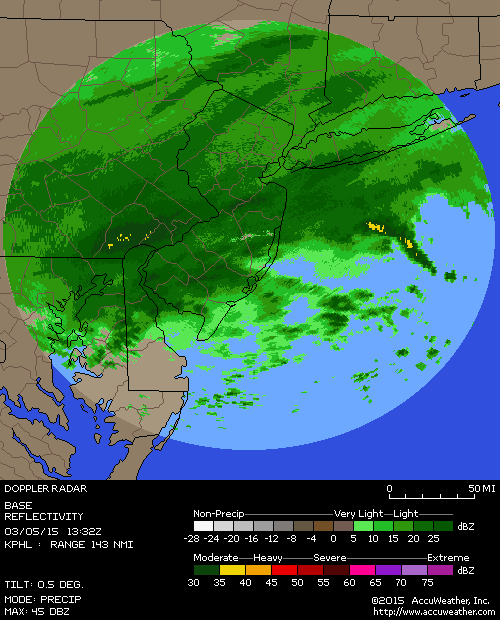
1:00pm: Whiteout conditions are being reported in NE NJ with the very heavy band of snow that is slowly pressing SE. Near-whiteout conditions can be expected within the next half hour in most of the NYC area, Middlesex County, Union, Staten Island, and parts of Long Island as well.
Radar as of 12:55pm shows a very heavy band of snow pressing down towards NYC. (Courtesy of Accuweather).
12:40pm: Dry air is filtering in on the north side of the system, but this is actually enhancing the banding towards NYC, because of the “squeeze” play it creates and thus more lift. Most of N NJ, NYC, and Long Island are about to have their heaviest snowfall rates of the storm — some spots could get 1-2″/hr rates for an hour or two.
9:30am: After a brief lull in the action in parts of NYC, the snow has become heavier again. This is because the strongest lift from wave one moved north of the area, while wave two was still organizing, so there was a lull in between. But notice how how the radar has really filled in and increased in intensity over the past 10-20 minutes.
Radar imagery as of 9:25am, courtesy of Accuweather.
What’s also important to note is that temperatures are falling quickly. This means that any main roads which were still only slushy will immediately become snow-covered. Temperatures have generally fallen below 30 degrees in most areas, and it was actually 28 in NYC at 9:00am. Any areas who are still above 30 degrees will fall into the upper 20s by 10:00am. This is consistent with the atmospheric profile becoming colder, which favors a finer, fluffier snow as opposed to the heavy wet snow. This snow tends to accumulate very efficiently. 6″+ of snow is likely in the heavier bands.
8:30am: Regional radar shows bands of heavy snow developing from Southeastern PA to Southern Long Island including Central New Jersey. These bands feature heavy snow and greatly reduced visibility. Deteriorating road conditions are occurring. Please travel carefully if you must.
These bands of heavy snow are expected to continue over the same areas over the next few hours — creating localized gradients of snowfall. Newer high resolution models indicate the potential for 4 to 6 inches of snow in many areas, with 6 or more inches in bands of heavier snow.
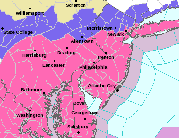
4:00pm: The National Weather Service has issued Winter Storm Warnings for most of New Jersey including the New York City Metro Area from late tonight into Thursday. Generally, their forecast calls for 3 to 6 inches of snow with higher amounts of 5 to 9 inches possible south of New York City throughout parts of Central New Jersey. Lighter amounts of 2 to 5 inches are expected farther north in New Jersey, where a Winter Weather Advisory is in effect. You can read the warning text here.
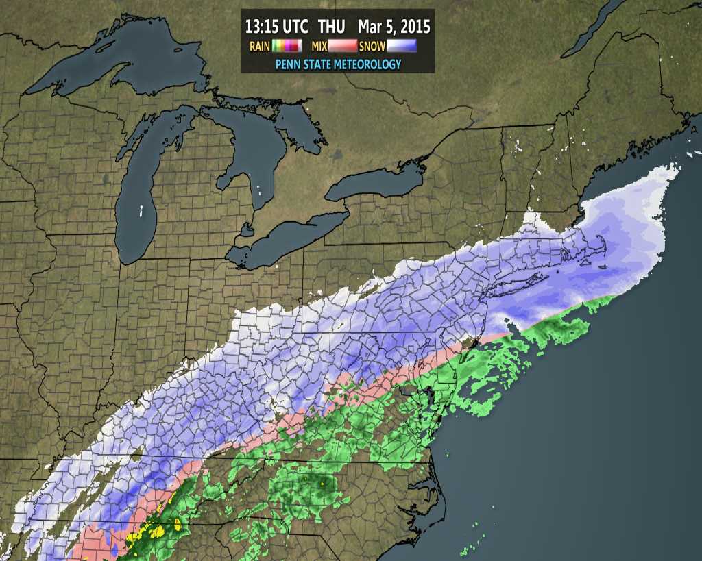
2:35pm: We are now beginning to get into range of the HRRR Model (High-Resolution Rapid Refresh). It updates every hour and only runs out to 15 hours in time. It can sometimes be good at pinpointing short-term trends in banding and changeovers from rain to snow. The latest HRRR model has rain changing to sleet at around midnight, then to snow at around 2:00am, and it comes down very heavily.
HRRR Model showing the changeover from rain to snow overnight (Courtesy of Weatherbell Analytics).
Hi friends! Our website uses cookies to provide an optimal browsing experience for you. New "Cookie Consent" laws mandate us to inform you of this. As long as you're cool with it, just hit OK. You'll only see this message once.
We may request cookies to be set on your device. We use cookies to let us know when you visit our websites, how you interact with us, to enrich your user experience, and to customize your relationship with our website.
Click on the different category headings to find out more. You can also change some of your preferences. Note that blocking some types of cookies may impact your experience on our websites and the services we are able to offer.
Essential Website Cookies
These cookies are strictly necessary to provide you with services available through our website and to use some of its features.
Because these cookies are strictly necessary to deliver the website, refusing them will have impact how our site functions. You always can block or delete cookies by changing your browser settings and force blocking all cookies on this website. But this will always prompt you to accept/refuse cookies when revisiting our site.
We fully respect if you want to refuse cookies but to avoid asking you again and again kindly allow us to store a cookie for that. You are free to opt out any time or opt in for other cookies to get a better experience. If you refuse cookies we will remove all set cookies in our domain.
We provide you with a list of stored cookies on your computer in our domain so you can check what we stored. Due to security reasons we are not able to show or modify cookies from other domains. You can check these in your browser security settings.
Other external services
We also use different external services like Google Webfonts, Google Maps, and external Video providers. Since these providers may collect personal data like your IP address we allow you to block them here. Please be aware that this might heavily reduce the functionality and appearance of our site. Changes will take effect once you reload the page.
-2")