Weekly Outlook 11/22-11/28: Cold Start…Mild Finish

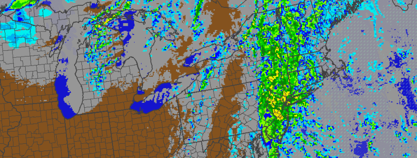
A cold front with limited moisture available will move slowly east of the region today. A wave of low pressure developing off the Southeast Coast will stay well offshore as well. However, our area will fall underneath the right-rear entrance region of a 130kt+ upper-level jet streak with an amplifying upper-level trough associated with the cold front. In simpler terms, this enhances lift in our region — aiding in the development of showers later today and tonight. A period of steady light or moderate rain is even possible for Eastern Long Island and Southern New Jersey, if the low offshore comes close enough.

With the offshore coastal storm aiding in the development of clouds as well, temperatures will stay generally capped in the 40s to lower 50s. Cold air advection increases during the day as well, which will bring temperatures down into the 30s and 40s by later this evening throughout the area.

Read more

Rain Likely Today…Colder Weather Arriving This Weekend

Today will be a dreary day. This morning will start with some clouds, fog, and a few light showers around. Then periods of steadier rain will arrive with a cold front this afternoon and evening. Model guidance shows a strengthening southeasterly low-level jet between 40kt-50kts and high precipitable water values over 1.30″, indicating high atmospheric moisture content. This will likely result in rainfall being heavy at times this afternoon and evening.

Model guidance shows little instability. But an isolated thunderstorm can’t be ruled out, considering the warm air advection and forced ascent occurring. Rainfall totals of 1″ – 2″ of are possible in parts of the region. The upslope flow with southeast winds could help enhance rainfall totals over higher elevations north and west of New York City as well. The stronger winds aloft are not expected to mix down to the surface; however, with a tightening pressure gradient, winds could gust in excess of 30mph in spots — especially near the shore or with any isolated thunderstorm.

Read more

The PDO, MJO and Their Potential Influence In This Upcoming El Nino Winter

When a forecaster makes a seasonal outlook or forecast, he/she must consider all possible climate drivers and variables with teleconnections. Previous articles such as Monitoring the Stratosphere and The Importance of High Latitude Blocking in Upcoming Winter discussed the variables that were considered for our winter forecast, and how much weight was put into each. Now it’s time to look at some other climate patterns in Pacific.  For example, this year’s strong El Nino is something you probably have heard the most about.

There is little doubt that a strong El Nino has a large influence over the atmospheric pattern in the Pacific Basin. Some have used the term “Godzilla El Nino” to describe this year’s phenomenon; which, while catchy, could perhaps be unneeded sensationalism. Another common thought is that after 1997-98 — the last “Super” El Nino, which was an extremely warm and snowless winter — that this winter will also be very warm and snowless in the Northeast. However, there are other climate patterns in the Pacific that can still have influence, even in the midst of such a strong El Nino, which makes such strongly-worded conclusions about this winter not justified.

Read more

An Early Look at the Pattern for Thanksgiving Week

The days before Thanksgiving are some of the busiest travel days of the year, meaning that the weather has an even larger impact than usual. Accordingly, we have already been keeping an eye on model guidance for this period. While it’s still too far out to forecast with confidence, our November outlook did show some cooling to near average later this month, with an overall warm month in the means. Not coincidentally, there does appear to be some kind of pattern change on the model guidance that has piqued our interest.

Forecast models and their ensembles have consistently showed above normal 500mb heights developing early next week over the Northeast Pacific. These heights extend up to Alaska, which causes the Eastern Pacific Oscillation (EPO) to go into its negative phase. Another ridge initially over the eastern US this will be forced to build into the Davis Strait and Greenland — temporarily bringing the North Atlantic Oscillation (NAO) down into its negative phase as well. This pattern will bring one or two cold shots into the Western and Central US on Thanksgiving week. The main questions are: a) will this airmass make it into the Eastern US, b) if so, how much (if any) modification will there be, and c) how long will this colder regime last?

Read more