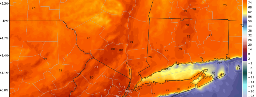
High pressure is giving us gorgeous day for this Wednesday. Temperatures already in well into 50s across the region this morning. High temperatures will be reach at least the middle 60s for much the area this afternoon. Some inland spots over New Jersey may see temperatures take a run at 70 degrees again this afternoon. Sea-breezes this afternoon will keep temperatures somewhat cooler near the shores.
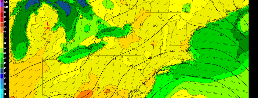
After a taste of early summer yesterday–with temperatures in the lower 80s in parts of the area–somewhat cooler temperatures are in store for today. A cold front has passed through much region with some clouds, early this morning. Partly sunny skies are anticipated for the rest of day with somewhat cooler airmass behind the front. However, northwest downsloping winds behind the cold are already causing temperatures to rise into upper 60s and lower 70s over the region. These warm temperatures will continue this afternoon, perhaps rising into the middle 70s is some spots.
https://www.nymetroweather.com/wp-content/uploads/2016/04/Water-Vapor-imager.png8191028Miguel Pierrehttps://www.nymetroweather.com/wp-content/uploads/2024/02/Empire-2000-x-300-px-2.pngMiguel Pierre2016-04-19 11:00:112016-04-20 19:21:13Tuesday Overview: Warm, Dry Conditions Lead to Brush Fire Danger
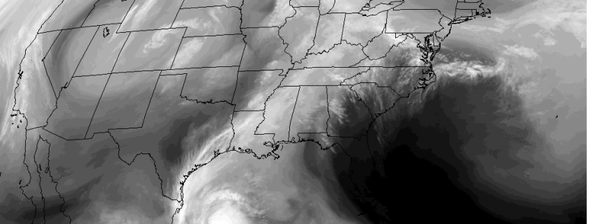
After an unseasonably chilly weather to begin April, more spring-like weather has arrived for region over this past weekend. Pleasant weather will continue much of this week. A cold front will moving south through the local region late tonight or Tuesday morning. Model guidance shows this front will most likely come through the region dry, with moisture very limited and best forcing well north and east of the region. The next chance of any rainfall of consequence will come late Thursday night and Friday.
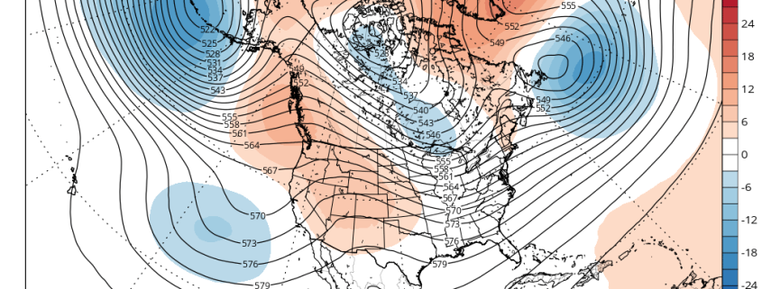
After much warmer than normal temperatures during March, April has averaged cooler than normal so far, with some unseasonable cold weather for some days. This weather might seem bit ironic since we’re moving further into the Spring season. Some major league baseball games have to been postponed due to more unseasonably cold weather and even wintry precipitation in Northern parts of the nation. There are signs of a warming trend going into this weekend and early next week. But there are signs that this may be interrupted again due largely to high-latitude blocking.
Later this week, a large, deep cut-off low over the Rockies will cause a strong ridge to build over the Great Lakes and Ohio Valley regions. Another cut-off low will form on the downstream side of the ridge, off the East Coast. Initially, model guidance showed this cut-off low backing towards the region and affecting our weather this weekend. But high-latitude blocking weakening this week allows this low to remain farther offshore.
Hi friends! Our website uses cookies to provide an optimal browsing experience for you. New "Cookie Consent" laws mandate us to inform you of this. As long as you're cool with it, just hit OK. You'll only see this message once.
We may request cookies to be set on your device. We use cookies to let us know when you visit our websites, how you interact with us, to enrich your user experience, and to customize your relationship with our website.
Click on the different category headings to find out more. You can also change some of your preferences. Note that blocking some types of cookies may impact your experience on our websites and the services we are able to offer.
Essential Website Cookies
These cookies are strictly necessary to provide you with services available through our website and to use some of its features.
Because these cookies are strictly necessary to deliver the website, refusing them will have impact how our site functions. You always can block or delete cookies by changing your browser settings and force blocking all cookies on this website. But this will always prompt you to accept/refuse cookies when revisiting our site.
We fully respect if you want to refuse cookies but to avoid asking you again and again kindly allow us to store a cookie for that. You are free to opt out any time or opt in for other cookies to get a better experience. If you refuse cookies we will remove all set cookies in our domain.
We provide you with a list of stored cookies on your computer in our domain so you can check what we stored. Due to security reasons we are not able to show or modify cookies from other domains. You can check these in your browser security settings.
Other external services
We also use different external services like Google Webfonts, Google Maps, and external Video providers. Since these providers may collect personal data like your IP address we allow you to block them here. Please be aware that this might heavily reduce the functionality and appearance of our site. Changes will take effect once you reload the page.
-2")