Good Evening!
The active hurricane season of 2017 continues on with yet another system developing, this time down near Nicaragua. Around two weeks ago, we highlighted that there was at least a moderate chance that the increased thunderstorm activity, below-average wind shear, and above normal sea surface temperatures would lead to some kind of tropical system during the first week of October. Like clockwork, we had a very large tropical wave move across the central Caribbean with an associated upper low just to its west. This greatly increased shower and thunderstorm activity over the area and began to lower pressures. Thunderstorms began to consolidate and yesterday the National Hurricane Center designated a small area of low pressure north of the Panama coast embedded in these showers and thunderstorms as Invest 90L with a high chance of development. Earlier today, surface observations and satellite data showed that the system had become sufficiently organized enough to be classified as the sixteenth tropical depression of the season with winds around 35 mph.
A little after one o’clock or so, the hurricane hunters flew into the depression to get a better idea of the systems strength and its overall structure. They did not find anything overly impressive, but they did find that the system did have a relatively well-organized center with winds around 35mph. The pressure was down to 1006mb, which is quite typical for these types of monsoonal depressions during the month of October. Since that time, the depression has not changed very much, but remains well organized with multiple curved bands and low level spiral bands present around the circulation. Convection is not all that deep at the moment, but this is to be expected during the afternoon hours with peak heating. As the sun sets and temperatures begin to cool, the temperature differential between the ocean and the cooler air aloft should spark numerous thunderstorms that should help the system begin to become better organized.
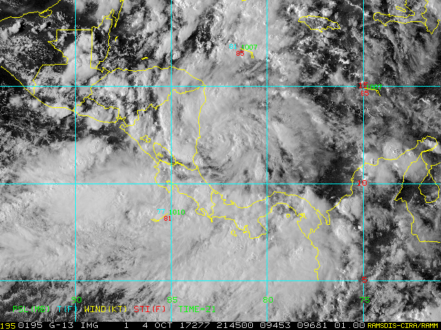
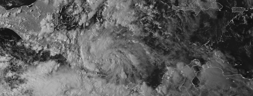
Visible satelite imagery of Tropical depression 16 just off of the Nicaraguan coast this evening with 35 mph sustained winds (RAMMB CIRA)
The depression should continue to gradually move towards the coast of Nicaragua over the next 12-24 hours, likely strengthening to a tropical storm in the process. This afternoons SHIPS text (which is a guide for intensity for cyclones) showed a rather significant chance that TD16 will rapidly intensify over the next 24-48 hours, with up to a 60% chance of the system increasing by 55 knots in the next two days. We will have to closely monitor this system over the next day or so to see how convection develops and organizes over the center. Since the system has a relatively small center already, it would not take much in the way of deep convection for the system to be able to begin to rapidly intensify over the extremely warm waters of the Caribbean and take advantage of the very strong Oceanic Heat Content below the system. History is also on the side of this system, as some of the most intense hurricane on record have intensified in the same area that this system will be tracking.
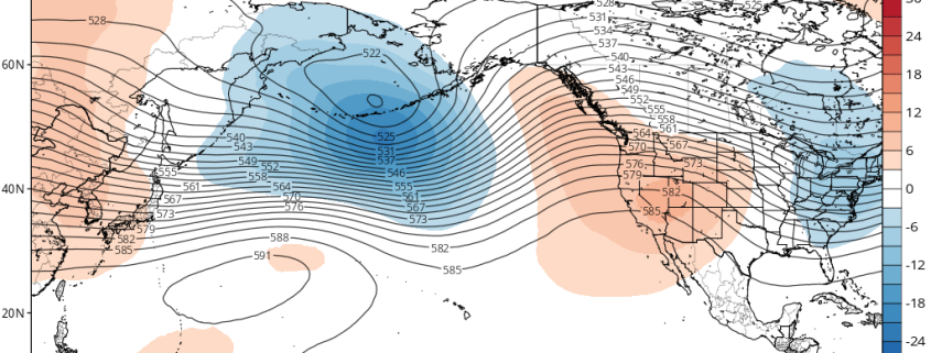
Regardless, it is likely that this system will be a moderate to strong tropical storm by the time it interacts with Nicaragua tomorrow afternoon. The system should exit central America tomorrow evening, and should be able to retain tropical storm strength as it reemerges over the Caribbean. Initially the cyclone will be over relatively shallow waters near the coast, but as it continues to accelerate north it will begin to encounter some of the warmest and deepest oceanic heat content in the world. This point will be crucial, as we will have to see if the system has a stable enough core post lander interaction. Upper level conditions will be quite favorable, with a large upper level low back away from the system off to the north and west, which should create a nice poleward outflow channel. This will allow for the system to effectively transport latent heat from the center of the storm. At this time, it seems that a strong tropical storm or minimal hurricane will be likely by Friday afternoon, when the system is nearing the Yucatan Peninsula.

Map showing the forecast points for TD16 with Oceanic Heat Content in the background. The yellow and orange values are quite high, and support a strong system.
TD16 should either pass over the Yucatan or just east by Friday evening, and eventually make its way into the Gulf of Mexico. At this point, the intensity of the storm will be highly dependent on the structure of the system, but if the system remains healthy and the core is not too disrupted from the Yucatan, then it appears quite possible that the system could enter the Gulf as a low-end Category 1 hurricane-possibly stronger if it gets its act together earlier in time. After this point, it becomes pointless to speculate on intensity once the system reaches the central Gulf by Friday, but the global models seem to indicate that there is good chance that upper level conditions will remain conducive for at least some intensification as the system approaches the Gulf Coast. TD16 should be nearing the Gulf Coast as early as Sunday morning, but the exact landfall point will likely not be known until Friday or so. For now, I would say that points from the “Big Bend” of Florida to the central Louisiana coast should keep a close on the progress of this system over the next few days as the overall intensity forecast for this system remains complicated and could change in a moments notice.
We will have an update on this system and its potential impacts for the Northeast later in the week!
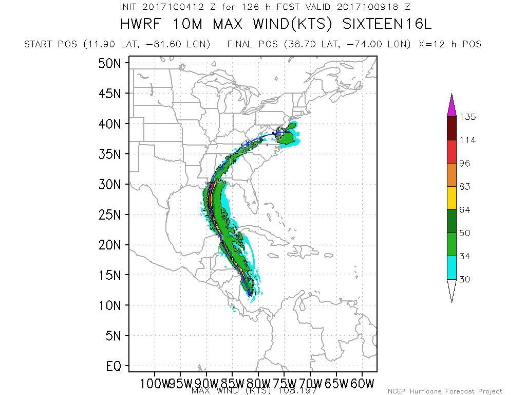
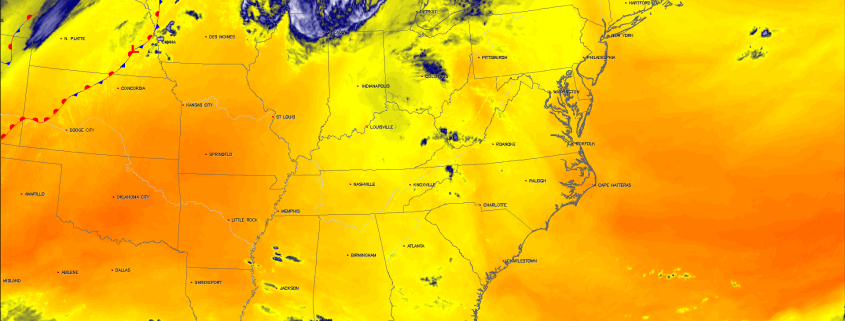
This afternoons HWRF model showing TD16 steadily strengthening into a strong hurricane before landfall along the Gulf Coast
For more information and posts like this one, make sure you sign up for Premium Forecasts — where multiple detailed articles, videos, and interactives are posted each day. Also, come interact with our staff and many other weather enthusiasts at 33andrain.com!
Have a great night!
Steve Copertino
-2")