Blizzard likely Tuesday with widespread significant snowfall

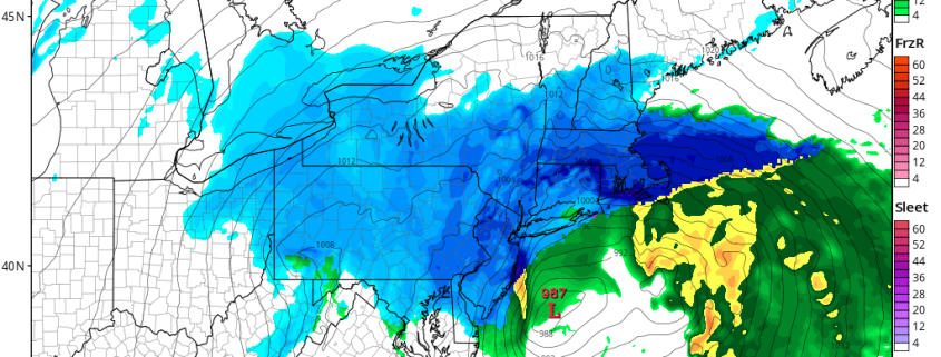
A powerful Nor’Easter is expected to develop off the coast of Mid Atlantic late Monday Night, strengthening and moving to a position southeast of Long Island on Tuesday. Bands of extremely heavy snowfall are expected to rotate inland from the strong storm system, impacting a large majority of the Northeast United States from Washington, DC to Boston — and most areas in between. Snowfall amounts are expected to be significant over a large area.

The storm system is developing as a result of a complex interaction in the mid and upper levels of the atmosphere, and some uncertainty still exists in regards to the exact track of the storm system. However, confidence is higher than normal that the storm system itself will bring significant impacts. We suggest planning ahead and adjusting your schedule as necessary to accommodate for significantly impactful weather on Tuesday. We’ve laid out a breakdown of the storm system below.

Read more

FREE 3/12 AM All Zones Update: Blizzard Likely Late Monday Night and Tuesday

A very cold airmass with well below normal temperatures continues to be over the region over the next few days. Today (Sunday), some instability in the atmosphere will cause some clouds to mix with sunshine with a few flurries possible again. But winds are expected to be lighter out of the northwest. So it won’t feel as harsh as yesterday. Temperatures should rise into the upper 20s to lower 30s. Overnight lows tonight will be the single digits and lower to middle teens over the region, as high pressure sitting overhead and calming winds support ideal radiational cooling conditions. On Monday, high pressure over will support plenty of sunshine during the morning hours. Then more high clouds will start increasing during the afternoon from the southwest. High temperatures will be a little warmer in the low to mid 30s.

Read more

PM Zone Update: Blizzard Watches issued ahead of significant storm

Confidence continues to increase on the development of a significant snowstorm early next week throughout all of our zones. As mentioned in detail over the past several days, two disturbances will drive southward into the Central United States late this weekend and early next week, in response to the development of a blocking ridge in the higher latitudes. These disturbances will interact and phase over the Mississippi River Valley and parts of the Eastern US early next week.

As the two disturbances interact, a strong low pressure system will develop across the Southeast US coast, shifting northwards up the Eastern Seaboard. The exact track of the system is still yet to be determined, and will greatly impact the ultimate impacts that the storm brings our area. However, the envelope of possible solutions continues to tighten — with most solutions impacting all of our zones at least moderate to significantly.

Read more

Increasing potential for significant snow next week

Four months have gone by since we first began tracking the potential for snow and cold in November. The best atmospheric weather pattern for significant snow chose not to arrive until the middle part of March. Yet, here we are, tracking the potential for a tremendous storm system to impact the Northeast United States early next week. Forecast models have begun to hone in on the development of a strong low pressure system off the coast, with tons of moisture and cold air available.

A few weeks ago, our forecasters were tipped off to this potential by the development of high latitude blocking. This is a critical component to any forecast, especially for cold and snow, and especially in the Northeast United States. See, these high latitude blocks are extremely disruptive to the atmospheric flow. Essentially, ridges of high pressure develop way up in the polar and arctic regions and “Block” the progression of systems through the region. They also dislodge cold air, which normally would be bottled up in the higher latitudes, further south into Canada and sometimes New England.

Read more